

DDweatherman
-
Posts
3,597 -
Joined
-
Last visited
Content Type
Profiles
Blogs
Forums
American Weather
Media Demo
Store
Gallery
Posts posted by DDweatherman
-
-
Interesting day in Kansas
613 PM CDT Sun May 19 2024 The National Weather Service in Wichita has issued a * Severe Thunderstorm Warning for... Eastern Saline County in central Kansas... * Until 645 PM CDT. * At 612 PM CDT, severe thunderstorms were located along a line extending from near Niles to near New Cambria to Assaria, moving east at 30 mph. THESE ARE DESTRUCTIVE STORMS FOR EASTERN SALINE COUNTY HAZARD...100 mph wind gusts and golf ball size hail. SOURCE...Radar indicated. IMPACT...You are in a life-threatening situation. Flying debris may be deadly to those caught without shelter. Mobile homes will be destroyed. Expect considerable damage to homes and businesses. Expect extensive tree damage and power outages.-
 1
1
-
 1
1
-
-
3 hours ago, Itstrainingtime said:
He's going to sell tickets. Who was the last Pirate that fans specifically bought tickets to see?
It dates back pretty far, I’d say Jonny Depp?
-
1
-
 2
2
-
-
The wife has mentioned one of her true bucket list items includes seeing the pyramids and going to Egypt.
2027, the max eclipse (totality is 6+ mins) is over Luxor, Egypt. That one is already in our plans")
-
3
-
-
Sadly didn't make it to Ohio since the weather was unclear heading in and driving 3 kids 5+ hours was a tough idea. Going to see 93% here in SCPA so should be a good experience nonetheless...maybe even get a little darker.
-
1
-
-
Probably 2” now at pen mar @Bubbler86
-
1
-
-
Snowing so hard liberty’s lights are gone from the back yard
-
That last squall did the job on covering the grass and deck really well.
-
2
-
-
3 minutes ago, Bubbler86 said:
Snow Squall Warning for just south of Lock Haven
SN+ moved back in now IMBY
-
1
-
-
Just now, Bubbler86 said:
I am tucked into my house down the hill but my tenant told me about the accum up. Not going to ask them to snap a pic. LOL
Snowing here again now. Pretty fun day. The squall that came through earlier this afternoon when we were grabbing dunkin in the boro was sweet. Drove back through Blue ridge summit and got to enjoy it twice.
-
1
-
-
7 minutes ago, Bubbler86 said:
Up to .2" here now. Everything covered except the roads. Going to set the grass back even more. I figured we would have a snowy day, but this is over top what I thought would happen down here. Over 1" in in Pen Mar up the hill. Top 10 23-24 winter day at this point.
I need a fort Ritchie/pen mar pic. Awesome, nice squall that covered a lot of things here passed through a bit ago
-
1
-
-
1 minute ago, MAG5035 said:
Laurel’s are looking pretty rough, specifically on the US 22 corridor right now in Cambria at the top of the mountain above Altoona.
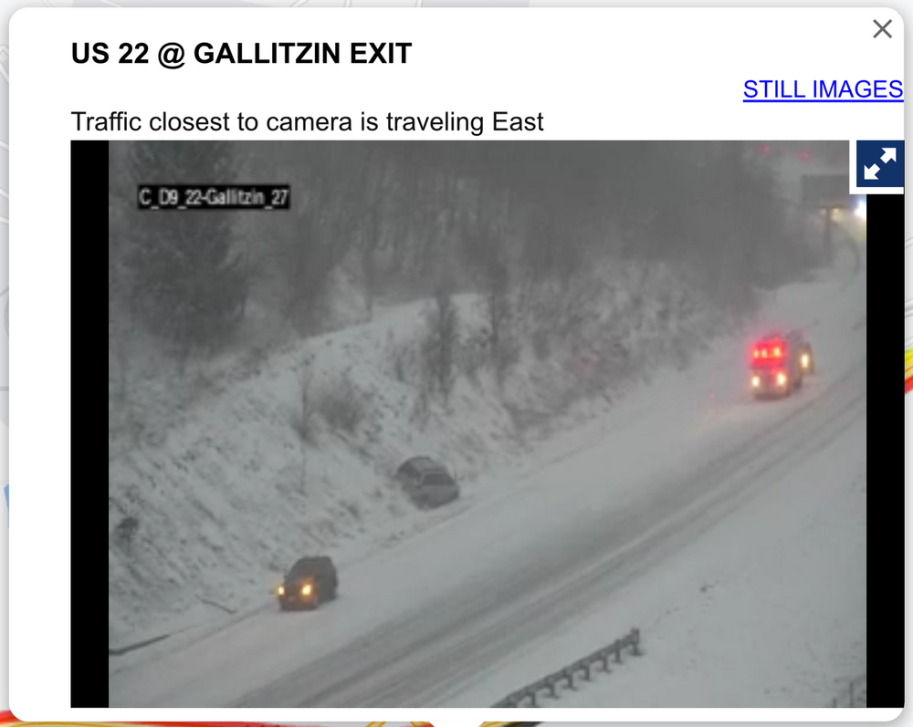
Pretty wintry down here too, with a coating of snow on the ground and occasional heavier snow squalls blowing around. But roads are uncaved at the moment. Temp is 30ºF
The band up in NC PA streaming through just north of Lock Haven is impressive. SSW issued and honestly some training there, can imagine localized couple inch totals will come in there.
-
Heavy snow in Carroll Valley, actually getting accumulation on grass and deck at the moment. 33
-
1
-
-
That was some very very heavy snow in Carroll valley for 20 or so minutes, vis was down to near 0 with gusty winds. Grass has some coverings along with the cars. Sun back out now. Let’s see if we can get one from the NW in a bit.
-
2 hours ago, katabatic said:
Greetings again from Donner! This epic storm continues. The entire front of the condo building has now disappeared. We’ve been taking turns at an entrance on the windward side, keeping that open (well, kinda) so at least we can get outside. To get this picture, I waded through waist to chest high snow. I have done multiple lake effect chases so I have seen some pretty intense snow but earlier today we had a thunderstorm that easily dropped 4 or 5 inches in 30 minutes. Still no power, no plow and no internet (phone works!) but warm and well fed. What a once in a lifetime experience for someone who loves this stuff.
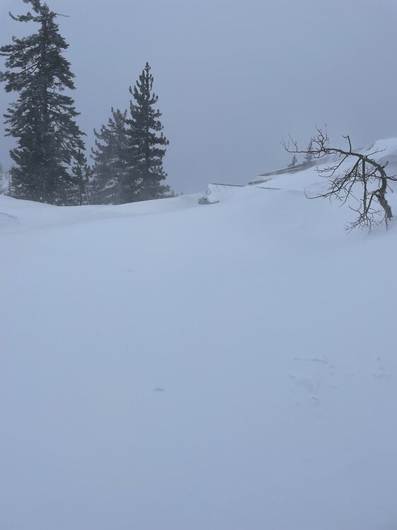
Need to experience this once in my life, 10 feet there?
wonder the frequency of a storm like this. Can someone pull the books? @psuhoffman
-
1
-
-
36 minutes ago, Eskimo Joe said:
Camp David gusted to 52mph.
It might be blowing greater than that here right now.
-
@Bubbler86 do you happen to have the asos link for ravenrock? I used to get those readings a few years ago and we just had a crazy gust across the road in Carroll Valley.
-
Great discussion above, the PDO seems to really be more a driving factor than it has been before. The “base state” comments really have merit given the Pacific just spoiling our chances more than once at a big dog pattern with staying power. I need to do more digging into the QBO to see if that has some pertinence since our longer term telecomms seem to be the bigger factor. Things like the MJO seem to mean a fair bit less than they used to.
also on a side note, why so much effort to move posts from thread to thread? This is a free forum and it’s volunteer work to be a mod. I salute the dedication, but seems like there are more important things in life than moving posts from thread to thread. There’s no weather going on currently.
-
1
-
 1
1
-
-
I had posted along with many Mets yesterday, and in the days leading up to this, if you’re in an area where the fronto is optimal, coupled with being in the right area for 850s, the ratios would be awfully high. Small pat on the back since that was spot on.
-
18 minutes ago, MAG5035 said:
Had another 0.3” from a squall when I was out cleaning up earlier, so bump the total up to 5.5”. Gauge is melting down now so I’ll see if I can get a ratio. Winds are kicking up.
Yeah we just added .2 as well
-
Just now, Fozz said:
Yeah many of the runs a few days ago had my area in between the bands, and with maybe 1-2” while places north and south would’ve gotten quite a bit more.
It sucks to see it close by, esp for the northern folks that were only 30-40 miles south of it, but I can’t complain too much with a 6.25” and a 3” in the same week.
-
1
-
-
Just now, psuhoffman said:
I doubt this is my last snow. If so it would be the earliest other than 2020 and 2023 when it barely snowed at all all winter. But just in case I’m enjoying this one.
View of the Catoctins looking west

looking south towards Manchester

Looking southeast towards Parrs Ridge. I’m technically on Dug Hill which is the next ridge NW of Parrs. The water tower you see is the highest point on Parrs Ridge!


Looking northwest, through those trees there is a fire tower along the next ridge of Dug Hill that’s actually the highest point in Maryland east of the Catoctins. It’s about 50 feet higher than me.


Great pics, it’s time to make the next storm happen. Shame modeling showed a nice back down last minute, but it’s been a big time IMBY sport this winter. I’m at 23” for the season which is one of the better #’s overall I believe, and 2 storms with 6”. Need a region wide hit sometime.
-
Just under 3”, nice scene out there. Maybe we can will the late week event into something solid?
-
2
-
-
3” here, beautiful morning. What could have been, but in reality the FGEN band even over our area would have had big winners but big losers in the subsidence zone.
-
1
-
-
Friday definitely has potential. If we get rain in a 986 off ORF the week of PD, that says a lot… maybe we will this one in


Late May 2024: Severe Threats
in Central/Western States
Posted
Kansas, look out
613 PM CDT Sun May 19 2024

The National Weather Service in Wichita has issued a

* Severe Thunderstorm Warning for...
  Eastern Saline County in central Kansas...

* Until 645 PM CDT.

* At 612 PM CDT, severe thunderstorms were located along a line
  extending from near Niles to near New Cambria to Assaria, moving
  east at 30 mph.

  THESE ARE DESTRUCTIVE STORMS FOR EASTERN SALINE COUNTY

  HAZARD...100 mph wind gusts and golf ball size hail.

  SOURCE...Radar indicated.

  IMPACT...You are in a life-threatening situation. Flying debris
           may be deadly to those caught without shelter. Mobile
           homes will be destroyed. Expect considerable damage to
           homes and businesses. Expect extensive tree damage and
           power outages.