

DDweatherman
-
Posts
3,597 -
Joined
-
Last visited
Content Type
Profiles
Blogs
Forums
American Weather
Media Demo
Store
Gallery
Posts posted by DDweatherman
-
-
Just now, mitchnick said:
Hopefully the 6z Icon is correct with its 3-4" this weekend.
That’s been the icon storm for quite a few runs.
-
 1
1
-
-
Just now, mitchnick said:
I see the location on your sig, but where is that in relation to MDT?
It’s like 45 min north I believe not far from Millersburg along the river.
-
 1
1
-
-
1 minute ago, Allsnow said:
This is going to be a big storm for the metro
32 light snow everything covered
Good luck over there guys. Once it switched over for me in this part of the storm, the rates immediately were 1”/hr+ and gave the 1/26/11 white meteor vibes.
-
1
-
-
1 minute ago, MillvilleWx said:
HRRR is a touch slow with the R/S line advancement, but it’s not too far off. Maybe 30 min. Snowing near Waynesboro now according to mPing. The bright banding on radar is wild.
I’m in the mountain cut in right at Liberty with the changeover happening about 30 mins ago. Immediately went to SN+
-
2
-
-
1 minute ago, Blizzard of 93 said:
Radar is juiced.
The next few hours should be show time.

This is awesome stuff blizz. You’ll enjoy these meatballs falling at 2”/hr
")
-
1
-
1
-
-
Always hard to estimate these type of flakes for rare type, but I’d estimate rate at 1.5”ph currently.
-
2
-
-
1 minute ago, mitchnick said:
Huge snowballs falling from the sky and starting to accumulate here.
Immediate road cave, winds kicking up too now.
-
Just now, MillvilleWx said:
Snowing in the Catoctins just to my north. Temp and dew point are plummeting in my hood as we speak. Probably a hour or so before it flips and rips.
Seeing snow reports on mPing across the PA line. HRRR doing a solid job with the R/S line advancement.
It’s a scene here already with these mashed potatoes falling.
-
2
-
-
It switched over here a bit ago. It’s absolutely dumping white meteors. Major 1/26/11 vibes with that one lol
-
4
-
1
-
-
Absolutely pouring snow, white meteors coming down
-
1
-
-
Can we move to ban the 10:1 maps the rest of the nowcasting time for this storm? @NorthArlington101 I'm lookin at you pal
-
2
-
-
Just now, Chris78 said:
Yes definitely less precip. Compare the latest run with the 18z. Big drop off with qpf
Funny as the king euro got wetter at 18z. I’m sure the rgem will look like the uk tonight lol
-
Just now, NorthArlington101 said:
snow depth again? smh. Making a meh run look worse than it needs to.
3k is slower to transition to snow than the RAP/HRRR/12k. It's a rates problem. Who knows which of the hi-res models will nail the banding. We'll find out in 12 hours
With some of the soundings we’ve seen and the strength of the low, I’m hard pressed to think we don’t have some great rates given that + the fronto and h5 pass
-
1
-
-
If Randy comes back for Nam pbp and progress is erased, it’s gonna be a riot
-
Just now, Blizzard of 93 said:
Dew points are in the 20s in northern PA.
They’ve been advecting slowly southward
-
2
-
-
Just now, snowmagnet said:
If only it could tuck a bit south of there...
I hear you, I think it may. The temps currently are actually dropping. Some noticeable CAA (tho the air isn’t that cold) bleeding in from the north.
you want a tickle from that n/s wave that has helped keep this south of previous progs. For one, it’ll help bleed in some more cold air, and two it’ll cause some nice dynamics on the NW side of the low. H7 and h85 lows do close off nearby
-
3 minutes ago, Bubbler86 said:
Cur my snow in half. The hrrr is really good at crazy hour to hour runs though so may not be a trend.
Rap didn’t look too bad most recently in its new run. Respectable outcomes for the lsv crew.
-
1
-
-
I mean, the primary low is already down to 995mb in the TN valley. Impressive at this stage. That transfer is gonna have a 987 over OCMD
-
2
-
-
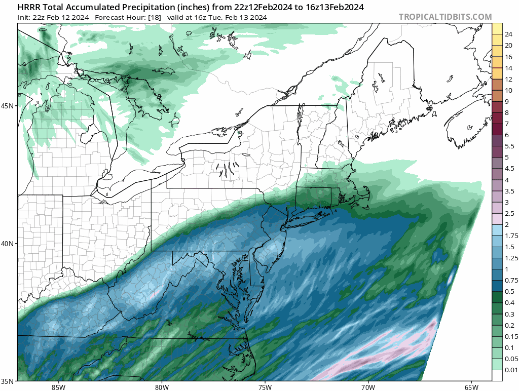
2 minutes ago, DDweatherman said:
2 run trend shows the QPF swath actually shifted south slightly on 23z HR3...after the last few bumps back north

-
2 run trend shows the QPF swath actually shifted south slightly on 23z HR3...after the last few bumps back north
-
1
-
-
8 minutes ago, MAG5035 said:
HRRR has quietly been involving a lot of the Mid-Atlantic folks from DC north with solid accumulating snow today, especially the newer runs. I think that’s rather ambitious but shows how far south this things have shifted heavy snow swath the last 24 hours or so. Those folks gave up on this event days ago.
It'll be crazy to see what the ground truth on this thing is. One of the more notable shifts inside 36 and 24 hours of recent memory.
-
1
-
-
3 minutes ago, psuhoffman said:
I don’t usually like to make bold long range predictions but I’ve decided Feb 13 might have potential for NW of 95.

-
7 minutes ago, Ravens94 said:

Another note is for all the people saying the de-amping is causing a weaker low, its actually trended 988 to 986 in the same frame over the last 3 runs.
-
The compaction of the shield is a tough one to know until very close to gametime. I expect an extremely intense band on the NW edge given this storms structure and some subsidence with the N/S wave pressing down on our low, which will be deepening pretty explosively. A 988 over the chesapeake bay in this set up is going to produce some serious rates and possible thunder snow. The tight shield if it verifies is just another point to believe this would fall extremely heavily in the snow zone.
-
5
-

Central PA Winter 23/24
in Upstate New York/Pennsylvania
Posted
Piling up, grass almost gone. 32/31