

DeltaT13
-
Posts
3,006 -
Joined
-
Last visited
Content Type
Profiles
Blogs
Forums
American Weather
Media Demo
Store
Gallery
Posts posted by DeltaT13
-
-
I hope anyone in Cape Coral is gone. That area is going to be 15ft+ under water.
Webcams from that area all look pretty run of the mill so far. Kinda odd. Just looks like a rainy breezy day so far. No sign of surge or flooding at all.
.-
 1
1
-
-
1 hour ago, nwohweather said:
Well what worries me is a continued east track and the Gulf Stream. Absolute jet fuel for a weakening system as it goes back out over the waterWhy does this worry people? Aren't we all here because we love big storms? There wouldn't be 165 members on this thread if we wanted storms to weaken. If people want to live in dangerous places that's there prerogative, I'm not going to stop being a weather enthusiast because people choose to live in high risk areas..
-
22
-
 3
3
-
 3
3
-
 6
6
-
 2
2
-
 1
1
-
-
Steinhatchee Fl, 110kts
. -
18 hours ago, wolfie09 said:
Pretty dead in here lol
Get ready to enjoy some fall like weather..
")
.png.9ad9ad0f7596e59be4b69989f0e86e79.png)
.png.463991ce3e06709b0d6ec3906dfafc8d.png)
.png.c9c584afc4ab78b0282586b2576421f2.png)
Yeah, I kind of gave up on this site when everyone fled to the Discord server and we lost all the contributors. My work actually my start using discord so maybe I'll give it a shot someday..
-
2
-
-
That 6z GFS would be a dream hit for us from that hurricane next week. I'd pay a lot of money to lock in that solution. A man can dream....
-
Freezing levels are very low today and some sizeable hail is pounding areas just South of my location, looks Henrietta to Scottsville is getting the brunt. I should have chased!
-
2
-
-
On 8/4/2022 at 11:11 AM, BuffaloWeather said:
I'll be in Alaska next week, looks like snow in the forecast while I'm there.


Winter storm warnings are out for Northern Alaska. Pretty unseasonable even for Alaska.
-
2
-
-
Looks like a legit tornado on the ground in Wyoming county. You can see debris in the air on the radar apps. Crazy gate to gate shear too. Seems like a long track for around here.
-
1
-
-
11 hours ago, TheClimateChanger said:
Agreed, although I think it may be worse than you think. Given what we've been seeing, which is often worse than what the models show, and factoring in the model projections for the year 2100, looks like there will be a permanent dust bowl over the central and southern Plains. That is to say, conditions akin to those present during the Dust Bowl will just be considered the base climate state as opposed to some extreme deviation from the norm. While the Great Lakes are projected to see precipitation increases, the summer projections show a modest decrease in precipitation - but more importantly, a large increase in the number of consecutive dry days and the number of days with extreme heat (90s, 100s) with the precipitation falling increasingly in occasional torrents - perhaps from tropical disturbances, or slow-moving gullywashers from time to time when the heat breaks. Makes sense with the Hadley cells moving north and expanding - should put much of the CONUS firmly in a region of predominantly sinking air. I imagine agricultural interests will find such conditions quite challenging. Will probably require substantially more irrigation.
I just get worried when I see widespread temperatures of 115-118F in the Pacific Northwest, and 100-104F in the UK (north of 50N), which are both heavily marine-influenced climates, but relatively dry in the summertime. What happens when this projected drying expands east into the Plains. There were temperatures up to 120F in the Dust Bowl all the way into the northern Plains. What happens in 2100, with CO2 at 500+, maybe substantially higher, in an already drying climate when a mega drought shows up - do we see temperatures of 130F, 140F, shattering world records? Will it just get so hot that crops simply desiccate and die in the extreme heat, such that no amount of irrigation will be sufficient?
These are all relevant concerns and I do see dark times ahead for a lot of the globe. I don't think we will skate through this without any ramifications here in WNY, but I just think our area is extremely well positioned to to ride this out in the next few decades with little tangible damage in our own backyards at least. That doesn't mean we won't feel the reverberations of large scale global concerns, but at least we shouldn't be feeling massive water restrictions (or likely any restrictions) or rolling blackouts, etc.
Your other concerns about agriculture are much more interesting and potentially unfounded. The way I've seen technology advance in just the last 20 years is nearly mind boggling. I have to assume that we will find ways to basically produce food on a synthetic/chemical level by the year 2100. All proteins, carbs, etc will likely be lab produced and far superior to anything we currently have. Raising livestock will eventually be completely unnecessary. I know it sounds kooky, but think replicator type stuff from star trek. And I'm sure we will have mastered indoor gardening on a scale that is unimaginable. I'm thinking massive skyscrapers or entire cities producing food on scales that would dwarf what we do now, all climate controlled and extremely efficient in regards to water use. There is also the possibility of a massive breakthrough in energy production that would then allow us to build massive carbon collection plants and desalinization plants. I think the next 20-30 years will be the hardest but I'm very hopeful that technology will help us fight our way out of this climate predicament in enough time. Let's just hope we don't have something far outside of our control like a massive kill shot from our sun that wipes us out...
-
3
-
-
7 hours ago, BuffaloWeather said:
The heat wave out in UK is quite worrisome. UK hit 40+ for the first time in its recording history.
The heat all over the world is getting pretty alarming but I can think of few places on this whole earth better suited for extreme warming than WNY. We have more water than we even know what to do with as Lake Ontario has flooded several times over the last 5 years and the great lakes are basically an endless source of fresh water (not to mention the fingerlakes). We have ample room during summers for it to get quite a bit warmer with no real issues other than hearing Tughill Matt complain
and our winters could certainly get much warmer without any true tangible consequences aside from pissing most of us off and maybe allowing some insects to survive the winter which could be a nuisance for some trees/plants. There are few places on this planet I'd rather be than right here if runaway global warming continues at the current rate. We are well insulated (no pun intended) from the deadly affects. I foresee our real estate becoming a commodity in the next 10-20 years. Sit tight friends!
-
1
-
-
.84 in my backyard. Not expecting a heck of a lot more but I’ll gladly take what we got.
-
1
-
-
7 hours ago, Polarbear said:
Even overnight? Nothing here during the daylight but I got 1.2” overnight
.33” overnight. Better than nothing but nowhere near enough. Under the big trees didn’t even get wet

-
Rochester getting shafted again in the rain dept. All the heavy rain is going South of us. Going to be heading into a full blown drought by this time next week.
-
On 6/26/2022 at 10:10 AM, SouthBuffaloSteve said:
Think we will see some spotty downpours roll through later tonight as the cold front pushes through.
Man I didnt even register .01" from that frontal passage and the next week looks very dry. It's going to be a grind watering ery'day!
-
Another day of disappointment coming for the Niagara frontier. Lake Erie is going to shadow us again. It’s soooo dry…gahhhh
-
8 minutes ago, Syrmax said:
Is there an actual limit to how many times you can be wrong? Or are u freeballing?
Every response to him is a win. He’s playing a different game that has nothing to do with weather. Just block and never respond.
-
2
-
-
Looking back there was a marine layer again that triggered the eventual main storms. The first batch near Buffalo was driven from something else upstream. Tracking that marine layer is critical and a combination of the hrrr and NAM had this event down very well. A touch behind on timing.
-
1
-
-
Meso models actually did really well with the Rochester and fingerlakes area. Almost nailed them to a T. Not too shabby. I thankfully got .45" of rain which is better than nothing. UR must have gotten almost 2 inches and some small hail.
-
1
-
-
40 minutes ago, vortmax said:

Something is happening...
Yeah this is unusual. Marine layer is apparently not in play right now. Storms are way further West than any Meso model had them. I expect outflow from that first batch of storms will blow up something huge over the Genny valley in the next 3-4 hours. I can see storms in Canada 50 miles away from my office window so these storms are building pretty tall.
-
1 hour ago, vortmax said:
It seems even when severe parameters are quite favorable, the marine air wins out every time. The only storms that seem to survive/thrive are the elevated warm frontal ones.
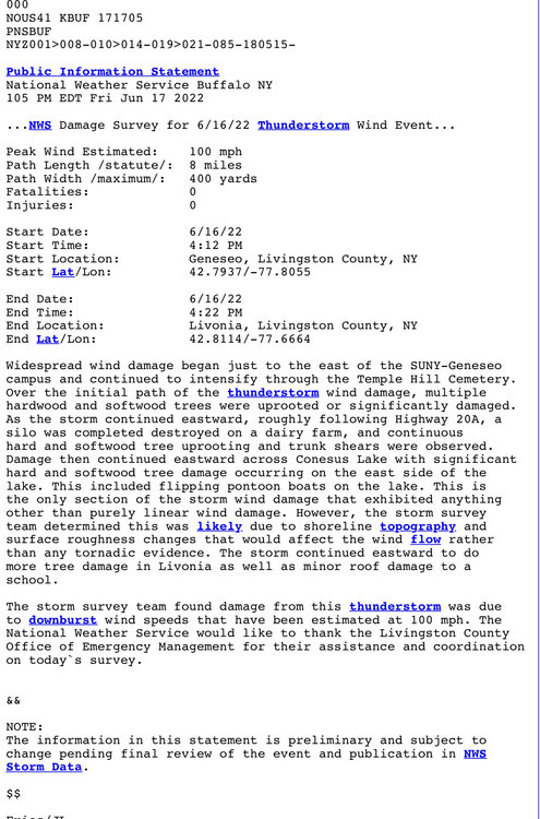
Well the boundary of the marine layer proved to be a massive trigger for a pretty high end event yesterday. The damage in Livingston and Ontario counties was pretty extensive. 100mph microburst/downburst really rocked portions of 20a.
-
Not one drop of rain today. Lake Erie is a bastard in these early summer setups.
-
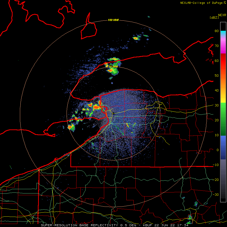
16 minutes ago, vortmax said:
* At 315 PM EDT, a severe thunderstorm was located over Youngstown,
  or 8 miles north of Niagara Falls, moving east at 45 mph.

  HAZARD...60 mph wind gusts and half dollar size hail.
That storm just east of you is the real mvp so far. Lake Erie marine layer is going to win this battle further west. Looking pretty ragged
-
You can see the marine layer from Erie on radar. These storms are going north and south of Rochester.
-
surface based CAPE values are slightly above 5000j/kg. That’s pretty amazing.
-
1
-


Hurricane Ian
in Tropical Headquarters
Posted
What do people think will be the highest wind speed recorded at ground level? All these eye popping numbers are substantially elevated in the atmosphere, I'll be interested to see what actually makes it down to street level. I'm thinking we should at least see a few 120mph or so.