

Typhoon Tip
-
Posts
42,023 -
Joined
-
Last visited
Content Type
Profiles
Blogs
Forums
American Weather
Media Demo
Store
Gallery
Posts posted by Typhoon Tip
-
-
7 minutes ago, 40/70 Benchmark said:
I don't really agree.
Looks pretty similar to me.

The strength matter there ... The stronger depiction ( right ) would lend to the stronger warm intrusion aloft -
-
1 hour ago, Brewbeer said:
Thread title is misleading.
We all wish this were the 25th winter storm of the winter.
Lol, ...I just caught this ... ha -
although, in a way it's entirely right - because the "25th" could certainly included all the missed opportunities, too.
-
 1
1
-
-
8 hours ago, MegaMike said:
I'm letting my weenie out. Someone mentioned it a little while ago, but the RAP is quite bullish for snowfall accumulations. The image below is using its imbedded SLR algorithm (computed between PBL time-steps) which is a conditional function of hydrometeor type (ice densities for snow and sleet is calculated separately then weighted as one) and the lowest model layer's air temperature. I like the spatial extent of the accumulations, but the magnitude is too high imo...

I wonder if the ratio/stack efficiency is being considered enough here ? - haven't heard/read much discussion related to that.
Presently, the hygroscopic temperature is quite deep here N of ~ HFD-PVD-TAN over SNE. However .. a key difference in this particular idiosyncrasy: unlike the typical wet bulb saturation temperature result ( 2/3rds to 3/4ths the distance toward the temperature side) this air mass is superbly back-built off -10 to +10 F (N-->S) polar-arctic air mass source that is not moving during the duration of this event.
I'm not trying to "bun" a way to get to those huge totals here ( hahaha) but if 1.2" of model blended QPF suspends through this column from any DGZ ... provided there isn't a sufficiently large amount of riming probably sends the ratios to or over 15:1 - I don't honestly know if there is a ratio calculator of sorts for deterministic efforts; that's just years of experience offering that suggestion.
If so, that's our 18" at maxes ...certainly 15".
I'm just offering one way to get it done that is still consistent with the synoptic metrics I'm looking at this morning. Heh, these system always provide at least tedious distractions for a turbo nerds - maybe this question is one of them. LOL
The caveats are:
warm layer at 800 - if that gets too close, the jig is up ... that impedes by densely compacting the aggregate... well, fluff factor drops.
speed of the system - I think this is moving very fast.. perhaps limiting, and adding to that ... if the nested frontogen banding "pulses" on rad, together we don't distribute enough QP anyway - you may have hinted at this by saying you liked the distribution but not the magnitude. Whether those are more stationary aligned somewhere between the Pike and rt 2, or over Rt 2 ...etc... would matter, because if a 2 or 3"/hr band were anchored for 3 or 4 hours, that'd do it.
-
Mein kampf looks a little NORLUNy into NE Mass Friday evening
-
35 minutes ago, 78Blizzard said:
Realistically, how much is going to change in a system like this in the next 24 hours? Your weighting right now looks good and is unlikely to change beyond some noise.
Not a whole helluva lot - unlikely.
Mine were spit ballin. But frankly the blended means been some 80% of where the consensus is now goin back three days.
-
I believe this is the biggest diurnal change of the entire season LOL… Seriously though – maybe go in the other direction but whatever
-
 1
1
-
-
I know!
let’s ask George what the weighting array should be …
-
1
-
-
4 minutes ago, RUNNAWAYICEBERG said:
Well if tomorrow runs come in a tick warmer aloft then yes. If they don’t then we can drop the weighting less and maybe even just toss it altogether if it keeps coming in colder itself. I dunno, I still see some wiggle room tomorrow so for now…I don’t mind.
Well sure. I mean the discussion on weighting probabilities is based on where we are heretofore up to this point. If things sig change tomorrow than the conversation’s moot - we’d have to come up with a different percent contribution
-
1
-
-
GFS 30%
ECM 25%
GGEM 20%
UKM 15%
mesos the remainder with less emphasis on the NAM in this aggregate mean for 10%
-
2
-
-
2 minutes ago, RUNNAWAYICEBERG said:
Yea. You can’t toss it completely. Your weighting makes sense.
I thinks that’s too heavy. Arithmetically, if we blend all other guidance, then take that mean and blend it with the NAM that’s given that helmet and drool cup kid one helluva participation trophy
-
3
-
-
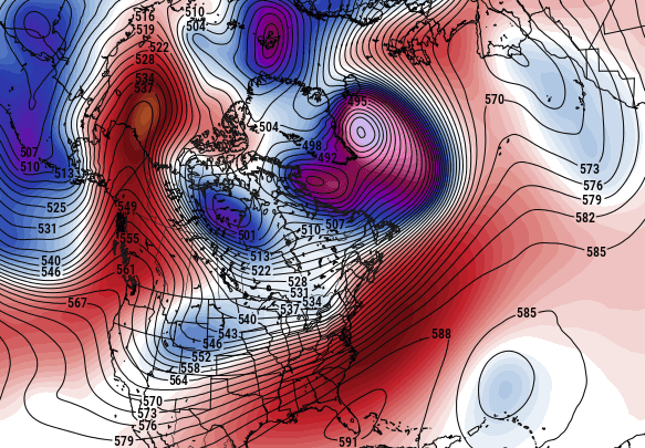
Folks should try and remember ...whether for muse or the educational value. This is the hemisphere on Friday morning according to the GEF's mean.
Looks pretty convincing snow stormy, huh -
-
2
-
-
I'm starting to wonder if the -EPO gush for mid March may be a red herring -
It's already a little less panache/attitude in the ens means out there - I haven't seen the 300 EPS but.. 240 ... Anyway the GEFs seems a little less impressive. Plus, we have to remember that radiative forcing across the hemisphere is a huge delta and it can start normalizing things particularly as we head deeper into March.
I was telling others that the EPO may not correlate on March 15 the same way as it does on Dec 30.
-
1 hour ago, SnoSki14 said:
If you think this temperature swing was impressive just wait till you go from 80s to 30s in April over 3-4 hours
We haven't had one of those type of BD events in quite some time. ... We've had our springs disrupted by other weirdness, causing wild oscillations of temperature that were not related to BD's per se - it may be that these odd springs have interfered with the general circulations types the cause the BD phenomenon. We've had them..but they've tended to shallower versions. I have to go back to the aughts of 2000 to get one of those big dawg shock and awe BD blasts.
The last I recall was April of 2003... I was working at the time down on Comm Ave, across from the BU rec center - which doesn't exist now..I think it's a gym and whatever... Anyway, it was 94 F at noon, partly cloudy with CU and some TCU toes along the horizons. The BD roared through the city, passing that location at 1:30 PM... The sky was interesting, with Kelvin-Hemholtz rolling scud fragments racing W, while the towers of cu leaned east over top. When I left to head up the street for the parking garage, I did so in 45 F ... essentially a 50 F correction between 1:30 and 5:30. It was 39 by 8 pm all the way out to Waltham where I lived. That BD never made as far west at ALB... That next day, I recall it was 86 out there, while it managed back to 43 still under slate sky back in Boston.
That was one of the more impressive ones I experienced, but the most was March 31 1998. It was 91 F ...in fact, it was D 3 of a 89, 90, 91. It was truly unique. I think those records will probably stand for a long while, as they have since. But at 3:15 pm on the 31, it was 91.4 F on the monitor at UML's wx lab. I looked at the obs up in Maine, knowing that the BD was coming... at that time, CAR's ASOS was 36 F with NE wind gusting to 45 mph. That radar had that serpent. Sometimes very powerful ones will get a weak ribbon echo ...probably because their plowing pollutants along - I dunno what drives that honesty. But it sinuous like a side-winder as it moved SW from out of Maine about to enter NH. It came through the Merrimack Valley around 5:45 ... with a lot wind and dust. 38 at dawn the next morning.
-
2
-
-
17 minutes ago, ORH_wxman said:
Btw, I watched him too. Amazing how much energy he still has. You can tell he still gets excited for these higher impact snow events. Lol. Hopefully he goes another couple winters before hanging them up…all time great. First ballot HOFer.
I recently was given the impression it may be this year
 ...
...
-
 2
2
-
-
1 minute ago, CT Rain said:
Synoptically this looks pretty good with that cold high to the north... not in retreat.
OH there you are
-
1
-
-
heh... jackpot could very well be where I'm located here in Ayer. In fact, I could see 15 or so mi either side of a line from Petersham, me, Lowell, Methuen maxing...
Still time to wiggle S(N) but for now
-
2
-
-
13 minutes ago, ORH_wxman said:
Lot of confluence up north....difficult to trend it hard north when you have a 1040 high sitting over Ottawa the night before. It's not like one of those SWFE's where the high is trying to hold on in Nova Scotia as the storm gets going.
Right - been a mantra of mine over some odd 20 pages in this thread: There's a limit in how far N this thing could trend in the runs.
Those N solution - NAM a separate matter ...hold on for a minute - were really pressed against the proverbial wall and could only come S. That was proven true when every next cycle subsequent of a N solution, halted or went the other direction. I guess some 'wiper blade' aspect but ... you know - the whole needle threading track oscillation noise.
The way around that N limitation would have/need to be a change in the (bold abv) scaffolding. But that's not happened yet, nor is there very much room in the hemispheric mode anchoring to assume any trend gets under way. If anything, this may come S even more - but cross the bridge.
The NAM? That idiot was just handling the total synoptic manifold differently, including that larger mechanical exertion - enough to allow it's solution. But like you said all morning, it's the only run really doing that and beside... Man, the NAM has a W-N bias at time ranges beyond 48 hours. It's funny - it's almost like it's gotta bias NW so bad that it re-engineers the circulation mode to get to it's obsession LOL
-
step 1 ... cold front.
Appears to be passing my location here in Ayer. Dark line of cu with wind shift and gustiness... 69 to 63 almost immediately
-
4
-
-
24 minutes ago, HoarfrostHubb said:
Tip?
Oh, you must be referring to that comment I snarked last night. I meant that in deference to that particular run, ...as in, the RGEM's rendition sucked.
The model may in fact suck, in general. But I'm not I don't use it? I get the sense for those that do, and comment on it... that it may have patterns it does better in. This season may not have featured very many of those -
-
1
-
-
Using the old NAM FOUS metrics from years ago ...
BOS
48048969471 07926 240917 42999399
54067989425 02209 090812 48000004
Looks just about split between snow and IP at Logan. That first 48 ( at 48 hours there ) is QPF in inches, falling through 980 = -1C, 900 = -7C, 800 = -1C
That -1C at 800 does argue for an elevated warm layer, but as we've collectively noted...the NAM is a bit of a NW outlier... (*the model typically is at this range*) ... These #'s don't evince temperatures above the 800 mb sigma.
The second line is .67" QPF in isothermal to 800, where that is +4C(39ishF) ... Probably that is toasting aggies at that temperature. Considering that leading up to the point in time ( 54 hours) there may have been a couple hours where it was at or warmer than this just above that 800 mb level. So that is likely IP ...and a goodly dose of it at that.
Looking at ALB's numbers ...they stay below 0C at all sigma levels on their grid... so... the classic (technique+experience with synoptic features in play) / 2 connotes snow along Rt 2... with and IP intrusion to the Pike or just N of that latitude.
By the way, this is mostly a latitude oriented affair when it comes to that.
-
1
-
-
12 minutes ago, CoastalWx said:
Some of the north ticks are the result of the shortwave moving north. Euro is one of them.
Yeah the biggest issue is snow total vs sleet cutting that down from where I'm sitting. I gather that folks would rather not the sleet... lol. Anyway, I'm more into this for the general impact to society, much less the general impact to the delicate sensibilities of people trying to get to some dimension of nostalgic d-drip psyche for the modeling journey before it even happens.
I mean, sometimes I wonder if that journey is more important than the actual storm itself. This engagement has evolved into something ( I wonder ) that is a part of that "60 Minutes" psychotropic stimulation addiction shit they covered as a problem to humanity by modern technology. But that'd be digressing...
I'm probably not really qualified to get too embedded in snow vs IP... In principle this is a "needle thread" system. And the system is going to run along the "rail-system" where the run lays the tracks - if the larger synoptic manifold change < 72 hour out..that's more an indictment of modeling tech. And the ptypes are 'edgy'
-
29 minutes ago, TauntonBlizzard2013 said:
It’s a defense mechanism. It’s also why some for are clinging to the NAM.
Hedge the warm solution to temper expectations
yeah... yeah I know. Stopped short at venturing why -
it's about as eye-rolling at the reader's side, as it is poking the hornet's nest to impugn the writer of that voice - best to just skip it, because it's never ended well.
I mean no one since the beginning of on-line weather "forumdium" has ever said, "gee, you're right - I'm being flawed logical in order to ameliorate my neurotic agenda. I'll cease from such tact.. " Uuuusually doesn't end well in the exchange. One is just not likely to be influenced, or corrigibly gathered in once they are triggered.
-
 1
1
-
-
Not sure I see why the UKMET is presumptively wrong, but okay.. Seems a bit impulsive.
This event's coverage this week has been rather revealing when it comes to load-balancing group pessimism vs optimism. The group tends to merely register a colder appealed cycle, but look out! We're making failure declaratives at the slightest giga motion of noise - that cannot be avoided at 72 hours lead btw. The hyper focus to do so makes autistic savantism look like ADHD. Lol -
Anyway, I still think the QPF is handling well. From the get go, some 5+ days, pretty remarkable synoptic consistency. There have been two distinct synoptic metrics in all guidance that really support QP going above the 'SWFE climotology' QPF suggestion.
-- deep latitude +PWAT air source
-- ancillary jet mechanics with superb lateral exit jet between 500 and 300 mb overarching N of the baroclinic wall/wave as it ripples underneath. The 500 mb is between this latter feature, and that upper air accelerating wind field. This should aid in propelling UVM slots and ( I believe ) we may see this punch into a deeper GZ than people think - possibly even as a modest behavior bust. ...this latter aspect is experimental... just sayn'. That's an extreme jet construct though.
...I suppose we should add fact that the idiosyncrasies of this set up has a polar high uniquely situated to really maximize BL resistance. This will have a compressed thermal packing closer to the boundary... Dry sleet affair where that happens. Also, I get the whole warm tongue stuff with a 10000 foot sleet column routine, okay - but this won't likely produce that kind of elevated layer. It doesn't have that kind of mechanical thrust between 850 and 700 to do so. This is unique in a sense ...it is maximizing QPF mechanics by accentuated lift of a higher PWAT air, out of less WAA above 1300 meters.
This is the way it has looked to me for days. I'm pretty set on NWS snow chart - I like what they've got.
8-12" along Rt 2 ...with a smear down to Brian... and points N (ratio inflation notwithstanding).
6-8" along the Pike, increasing sleet contamination S.
4-6" with sleet and ZR ~ HFD - PVD ...
1-4" S. Shore with ZR/IP. Cape as usual will require an intervention by a team of specialists
-
2
-
 1
1
-
-
1 hour ago, ORH_wxman said:
You can get like 5 to 1 sleet ratios if it’s really cold with a ton of pixie dust mixed in but that type of ratio usually doesn’t happen over a long period of sleet. Best to assume 2 to 1 or maybe 3 to 1 in a colder profile.
We actually had that here, that 5 .. 6::1 sleet bomb, from that event that was... jeezus, fore' or aft the blizzard. But we had it climbing up the tire walls in driveways and plow-able deep. I was dweebing it checking out the particulates in the pack on top of the car and could not find a snow aggregate, yet it was like 4"


February 2022 Obs/Disco
in New England
Posted
Do you really think that -EPO is all the bluster though?
You know I'm beginning to have my doubts. Take this for example ... last night's GGEM and Euro operational runs move a close 540 dm ridge node through the Alaskan sector, between day 2 and day 6.
540
That's what's come of the -EPO that was forecast for this episode back when it was 10 or 12 days in advance, when I recall that being significantly more amplified in the model depiction/vision...
Point being, the tendency to over-do that blocking up there seems air apparent, and I am noticing subtle nuances in the GEFs to belay ( also ) the -EPO it has. ...I'm just a little leery of the 'over magnification' thing getting into deterministic territory/ranges as not being as "instructive".
The other aspect is more orbital ...we are about to really transform the hemisphere by radiative forcing ( seasonality ). The 00z operational Euro, excluding details..., in principle shows a 'flashing' of the hemisphere, with a pattern break down and sudden warming of 850 mb layout over the Canadian shield. GGEM does too... The GFS doesn't but that model has a ranging speed hard-on in July so ...
Anyway, I'm just not as sold on cash-in result from mid March. Obviously, we can get blizzards until May 10th around here. This doesn't preclude the 1997's or 1977s or 1888s... But barring those, I'm not sure the pattern really is 'dependable'