

stormtracker
-
Posts
64,402 -
Joined
-
Last visited
Content Type
Profiles
Blogs
Forums
American Weather
Media Demo
Store
Gallery
Everything posted by stormtracker
-

Outta gas and Outta Time: Early March Winter Storm finale
stormtracker replied to Ji's topic in Mid Atlantic
Just looking at the GFS now and you just gotta laugh at how there's a ton of cold pressing just on top of us and the GFS in previous solutions not holding on to snow or frozen. Maybe this run will change -
2/26 - Follow-up Hopium Battlezone Storm
stormtracker replied to DDweatherman's topic in Mid Atlantic
Was there before that last storm before they all moved toward it? -
2/26 - Follow-up Hopium Battlezone Storm
stormtracker replied to DDweatherman's topic in Mid Atlantic
Yeah, it's interesting. This close in and it hasn't blinked. Rerun of last week. I don't think it's going to happen, but I no longer laugh at the GFS when it gets like this. -
2/26 - Follow-up Hopium Battlezone Storm
stormtracker replied to DDweatherman's topic in Mid Atlantic
Differences between GFS and every thing else is reminding me of last week's mess. GFS is like a dog with a bone...it's not letting go of the wintry potential in THIRTY HOURS vs zero/south with every other piece of guidance. -
2/26 - Follow-up Hopium Battlezone Storm
stormtracker replied to DDweatherman's topic in Mid Atlantic
GFS just won't give up -
2/26 - Follow-up Hopium Battlezone Storm
stormtracker replied to DDweatherman's topic in Mid Atlantic
Bout time to bail on this one -
Outta gas and Outta Time: Early March Winter Storm finale
stormtracker replied to Ji's topic in Mid Atlantic
This man abandoned us for snowier pastures. Single handedly reduced the black population in this forum by 25%. I will not forgive. -
Outta gas and Outta Time: Early March Winter Storm finale
stormtracker replied to Ji's topic in Mid Atlantic
Looks like a 2-3, maybe 3-5 deal? I can't tell with these shit SV maps -
Outta gas and Outta Time: Early March Winter Storm finale
stormtracker replied to Ji's topic in Mid Atlantic
I'm talking to myself. There are 9 people in this thread. I'm going to bed. But the Euro is a good hit..that's the TLDR summation. -
Outta gas and Outta Time: Early March Winter Storm finale
stormtracker replied to Ji's topic in Mid Atlantic
Round two comes in at 156..starts as snow/mix and then we lose thermals hard at 162 -
Outta gas and Outta Time: Early March Winter Storm finale
stormtracker replied to Ji's topic in Mid Atlantic
North, where are the pretty maps -
Outta gas and Outta Time: Early March Winter Storm finale
stormtracker replied to Ji's topic in Mid Atlantic
It's a pretty modest hit from what I can tell. I don't have the pretty clown maps. -
Outta gas and Outta Time: Early March Winter Storm finale
stormtracker replied to Ji's topic in Mid Atlantic
This looks good so far..some light/mod snows at 135. kinda heavy at 138 ?moderate at 141 Looks like a MA special here -
Outta gas and Outta Time: Early March Winter Storm finale
stormtracker replied to Ji's topic in Mid Atlantic
some light snow at 144 -
Outta gas and Outta Time: Early March Winter Storm finale
stormtracker replied to Ji's topic in Mid Atlantic
Alright, out west slug of precip entering the pics. We're a bit warmer than 18z attm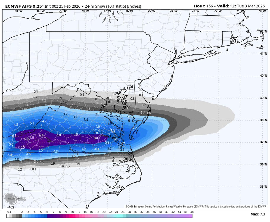
-
2/26 - Follow-up Hopium Battlezone Storm
stormtracker replied to DDweatherman's topic in Mid Atlantic
Yeah, 0z Euro still hates this thing -
Outta gas and Outta Time: Early March Winter Storm finale
stormtracker replied to Ji's topic in Mid Atlantic
Yeah, push south was def noticeable. And damn, didn't know AI had that much. I don't pay much attention to them -
Outta gas and Outta Time: Early March Winter Storm finale
stormtracker replied to Ji's topic in Mid Atlantic
Lose the thermals at 168 during decent QPF -
Outta gas and Outta Time: Early March Winter Storm finale
stormtracker replied to Ji's topic in Mid Atlantic
CAD is much more entrenched, but this seems like non snow winter precip coming in at 165 -
Outta gas and Outta Time: Early March Winter Storm finale
stormtracker replied to Ji's topic in Mid Atlantic
Yeah, GFS is def colder so far..waiting for the next slug of moisture to come through post 150. EDIT..lol, also much lighter with QPF. oof -
Outta gas and Outta Time: Early March Winter Storm finale
stormtracker replied to Ji's topic in Mid Atlantic
GFS is a bit colder starting out so far vs 18z.. Still warmish for lowlanders, but it's definitely bringing in the cold press earlier and a bit further south -
Outta gas and Outta Time: Early March Winter Storm finale
stormtracker replied to Ji's topic in Mid Atlantic
Man, fuck them birds. -
Outta gas and Outta Time: Early March Winter Storm finale
stormtracker replied to Ji's topic in Mid Atlantic
Come on man, whatever happened to promises made, promises kept. -
Outta gas and Outta Time: Early March Winter Storm finale
stormtracker replied to Ji's topic in Mid Atlantic
Boo! -
Outta gas and Outta Time: Early March Winter Storm finale
stormtracker replied to Ji's topic in Mid Atlantic
My man!


