stormtracker
-
Posts
64,391 -
Joined
-
Last visited
Content Type
Profiles
Blogs
Forums
American Weather
Media Demo
Store
Gallery
Everything posted by stormtracker
-

The Jan 31 Potential: Stormtracker Failure or 'Tracker Trouncing
stormtracker replied to stormtracker's topic in Mid Atlantic
Forgot all about it. No huge differences so far -
The Jan 31 Potential: Stormtracker Failure or 'Tracker Trouncing
stormtracker replied to stormtracker's topic in Mid Atlantic
I got one more Euro run in me. After that, it's time to eject. -
It's going to fall apart. What else we got?
-
The Jan 31 Potential: Stormtracker Failure or 'Tracker Trouncing
stormtracker replied to stormtracker's topic in Mid Atlantic
If anything, NAM is worse, so there goes that hope of wester at 0z -
The Jan 31 Potential: Stormtracker Failure or 'Tracker Trouncing
stormtracker replied to stormtracker's topic in Mid Atlantic
You crazy for doing throwing crumbs to starving people -
The Jan 31 Potential: Stormtracker Failure or 'Tracker Trouncing
stormtracker replied to stormtracker's topic in Mid Atlantic
-
The Jan 31 Potential: Stormtracker Failure or 'Tracker Trouncing
stormtracker replied to stormtracker's topic in Mid Atlantic
Calm down, Maryland Line. -
The Jan 31 Potential: Stormtracker Failure or 'Tracker Trouncing
stormtracker replied to stormtracker's topic in Mid Atlantic
Yeah, the low lighting really accentuates my features. -
The Jan 31 Potential: Stormtracker Failure or 'Tracker Trouncing
stormtracker replied to stormtracker's topic in Mid Atlantic
Not sure why they didn't use my pic on the bus
-
The Jan 31 Potential: Stormtracker Failure or 'Tracker Trouncing
stormtracker replied to stormtracker's topic in Mid Atlantic
0z is it for me. If no movement, I think we're cooked. Euro just did enough to keep me hanging on. -
The Jan 31 Potential: Stormtracker Failure or 'Tracker Trouncing
stormtracker replied to stormtracker's topic in Mid Atlantic
It knows. It's trolling at this point. -
The Jan 31 Potential: Stormtracker Failure or 'Tracker Trouncing
stormtracker replied to stormtracker's topic in Mid Atlantic
we still don't get much, but kinda funny that it got closer -
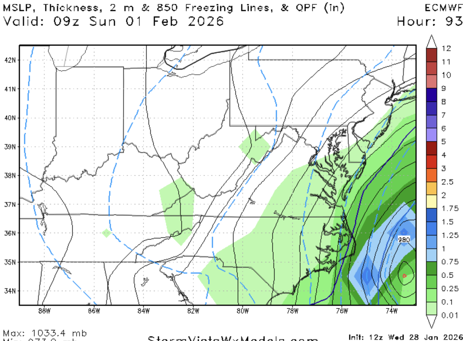
The Jan 31 Potential: Stormtracker Failure or 'Tracker Trouncing
stormtracker replied to stormtracker's topic in Mid Atlantic
low on the coast..before, it was off. We still miss, but it's closer 18z 12z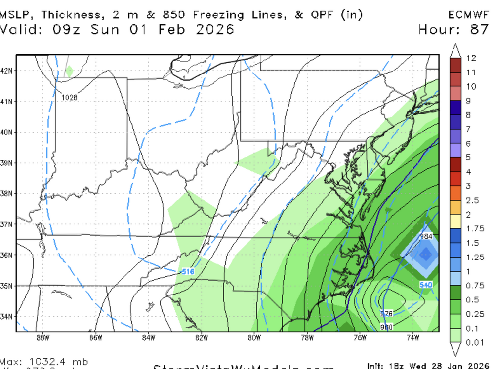

-
The Jan 31 Potential: Stormtracker Failure or 'Tracker Trouncing
stormtracker replied to stormtracker's topic in Mid Atlantic
12z18z
-
The Jan 31 Potential: Stormtracker Failure or 'Tracker Trouncing
stormtracker replied to stormtracker's topic in Mid Atlantic
lol, Euro slightly better -
The Jan 31 Potential: Stormtracker Failure or 'Tracker Trouncing
stormtracker replied to stormtracker's topic in Mid Atlantic
Yeah. It’s almost time. Gonna wait to 0z to call it. -
The Jan 31 Potential: Stormtracker Failure or 'Tracker Trouncing
stormtracker replied to stormtracker's topic in Mid Atlantic
It's better. But not good enough -
The Jan 31 Potential: Stormtracker Failure or 'Tracker Trouncing
stormtracker replied to stormtracker's topic in Mid Atlantic
tick west. Nothing exciting. It's going to likely look like it's last run. -
The Jan 31 Potential: Stormtracker Failure or 'Tracker Trouncing
stormtracker replied to stormtracker's topic in Mid Atlantic
Maybe that'll bring the storm back. -
The Jan 31 Potential: Stormtracker Failure or 'Tracker Trouncing
stormtracker replied to stormtracker's topic in Mid Atlantic
Next -
The Jan 31 Potential: Stormtracker Failure or 'Tracker Trouncing
stormtracker replied to stormtracker's topic in Mid Atlantic
Anyway, so far..Euro about the same as 6z -
The Jan 31 Potential: Stormtracker Failure or 'Tracker Trouncing
stormtracker replied to stormtracker's topic in Mid Atlantic
I skipped right over the ai part. Thought you meant Euro -
The Jan 31 Potential: Stormtracker Failure or 'Tracker Trouncing
stormtracker replied to stormtracker's topic in Mid Atlantic
He loves sniping at me for some reason, lol. I would have let him actually believe that was me. -
The Jan 31 Potential: Stormtracker Failure or 'Tracker Trouncing
stormtracker replied to stormtracker's topic in Mid Atlantic
Delayed at SV. Weird -
The Jan 31 Potential: Stormtracker Failure or 'Tracker Trouncing
stormtracker replied to stormtracker's topic in Mid Atlantic
Euro seems delayed