-
Posts
1,906 -
Joined
-
Last visited
Content Type
Profiles
Blogs
Forums
American Weather
Media Demo
Store
Gallery
Posts posted by Iceagewhereartthou
-
-
High of just 55.2 today. 1.42 in rain, more coming.
-
29.5 for me. 27 at Pickens County airport SC.
-
I, for one, am LOVING the dryer weather. After more than 250 inches of rain since Jan 2018, a couple weeks without floods is nice indeed!

-
 1
1
-
-
Wow, GSP not forecast to go below 41 over the next 15 days! That's rediculous, this isn't April.
-
Well fellas, I'm not forecasted to get below freezing again on the 16 day so I have officially thrown the towel on winter this year. Getting (appreciable) winter weather after March 10th has only happened a couple of times in my lifetime. I'll wait to give my official winter grade till April (I know everyone is waiting with bated breath). The mountains may still do well but I think it's about over for my area.
-
1 hour ago, burrel2 said:
This wasn’t a storm that typically bust in our favor for cad. Those are storms with an eroding wedge(models erode too fast) or an anonymously dry air mass.
waiting on cad to kick in is usually delayed compared to what models show, and often doesn’t work out. Especially without cold dry air already in place across the region.
Just the latest example of a CAD not always over performing. That's the biggest myth repeated on the board.
-
 2
2
-
-
Made it down to about 41, clouds came in, back up to 42.5 quickly, DP 30.

-
Some roads near Easley have been brined, I guess bc of the WWA. Not expecting any issues here though.
-
 2
2
-
-
1 hour ago, jburns said:
Then there are those of us who just have to walk a few feet to escape winter’s wrath. Since the county line runs right through my house I have a Winter Storm Watch in my garage, dining room and den but the rest of the house is in the non-event zone. I guess I should be thankful that I will only have to worry about the trees on the northern part of my property.

At least the southern portion of your house will still have power!

-
Wow guys, this is one time I'm happy to be in the upstate and not in WNC. I hope this trends to sleet or warms to rain for you guys, that kind of ice would be AWFUL.
-
-
1 hour ago, AirNelson39 said:
So over this shit hole winter. The models have been absolute trash for anything over 6 days. We had widespread agreement on cold and winter weather and both kept getting pushed back until they are just non existent Unreal. Bring on a nice cool Spring.
Based on what was advertised, almost unanimously, it's one of the bigger disappointments and rip offs I can remember. Definitely hard to swallow.
-
 4
4
-
 1
1
-
-
The biggest way we know this next week is a lost cause is that Burrel stopped posting. That says it all.

-
21 hours ago, Iceagewhereartthou said:
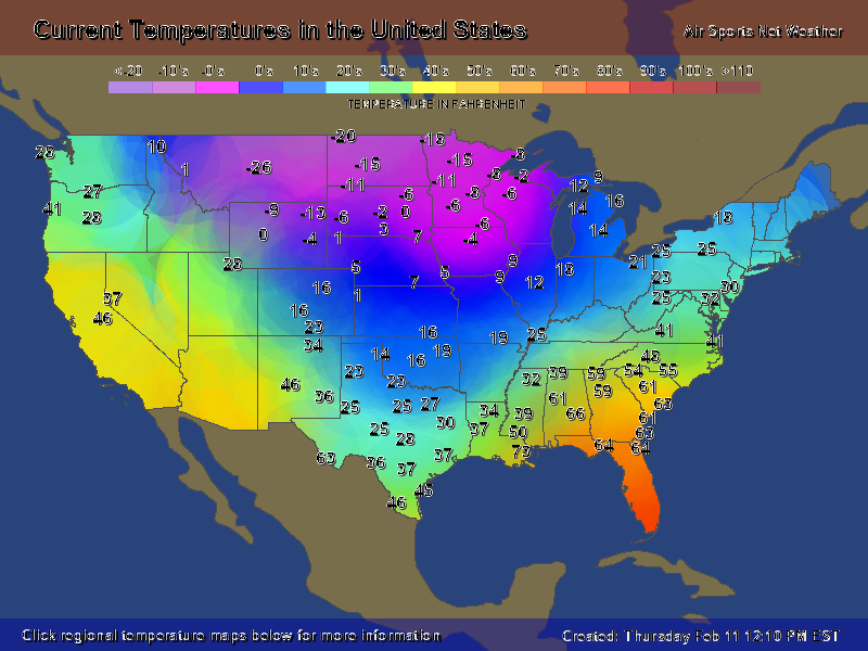
This is the current map. It really shows the tough in the middle of the country and this seems to have been the prevailing pattern this year, with almost no movement East. It's strange, despite not having a major SER this year it's been there enough to keep out the true cold. Next week the cold looks to be magnified and epanded a bit East to LA/MS/AL, but basically seems to stay in place.
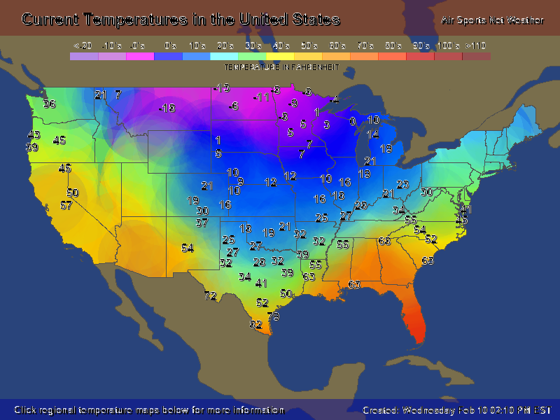
And here's today's image. Again,the position of the trough and SER are very clear. Unfortunately this looks to be the case for the next week leaving us in the warm and wet sector. Just too bad we could get it to move East!

-
 1
1
-
-
2 minutes ago, yotaman said:
I am also amazed that all that artic air won't make it over the Apps. Just shows how shallow it is.
This is the current map. It really shows the tough in the middle of the country and this seems to have been the prevailing pattern this year, with almost no movement East. It's strange, despite not having a major SER this year it's been there enough to keep out the true cold. Next week the cold looks to be magnified and epanded a bit East to LA/MS/AL, but basically seems to stay in place.

-
9 minutes ago, burrel2 said:
It’s is pretty locked in that eastern Texas, Louisiana, Arkansas are going to get an major winter storm. Must be nice.
And maybe multiple ones. This could be their March 1960 pattern. What a week to 10 days they are in store for based on the overall pattern evolution and the amount of cold on that side of the apps.
-
7 minutes ago, magpiemaniac said:
The Appalachians have been setting better picks than Duke lately.
Just maddening to have that level of cold at the same latitude a few hundred miles away and hardly get a piece of it. 60 degrees difference b/w Columbia SC and Jackson MS!
-
 1
1
-
-
1 hour ago, CaryWx said:
Yes but the cold air retreating allows the LP amplification in my view not the other way around. Modeling this cold vortex has and remains to be problematic.
If I were a betting man...we will not see this brutal cold in the triangle...or only for a very short-lived period of time. It will still be chilly (not warm) for sure but this is February after all
Fair enough!
-
45 minutes ago, msuwx said:
The big reason the 12z Euro is 'warmer' than the 0z for Tuesday is that the 500mb energy goes negative tilt over the central Gulf Coast, and the surface low matures and is much stronger, much sooner on the 12z compared to the 0z.
The overall signal has not changed, and there are going to be tons of changes as the models resolve:
- the depth of the cold, arctic air
- the strength, orientation of individual short waves
- the strength, placement of the CAD-inducing high
- many other moving pieces.
I strongly suggest folks to check their emotions with the wild swings that are sure to come.
Excellent post. I think negative tilt is pretty hard to forecast, especially this far out. This solution is factoring it in, but it's one detail of the whole picture that has a drastic effect on the outcome. If that tilt were not part of this particular run, think about how that might change the output of the storm. The low may be much father south, weaker, and allow the cold high confluence to remain longer and stronger. The model could easily change that particular detail in a future run and then we have an icy and colder solution again. Way too much time to go on this one. The ingredients are there, but we likely won't have a good idea till Sun or Monday, if not even go time. I still don't think we have a great picture of this weekend's system.
-
 1
1
-
-
12 minutes ago, NorthHillsWx said:
Jake Bentley is still gonna take y’all to the playoff just you wait...
I regress, no need for that pettiness. We’re all beat down by the 00z suite
What is a playoff?

-
 1
1
-
-
12 minutes ago, NorthHillsWx said:
Welp. I’ll take South Carolina football fans’ approach to every season: there’s always next year
Hope it works better for you than it does for us.

-
28 minutes ago, buckeyefan1 said:
I’m right there with ya 4 miles south of 85 in Greenville


Did you get blanked?

-
16 minutes ago, kvegas-wx said:
Not disagreeing, I'm simply pointing out (while I sit here in Cincy watching it puke snow outside) that starting tomorrow the high temps here wont go ABOVE 25° until the middle to end of next week. This isnt run of the mill transient cold. This has staying power. And we would need a monster SER to block and/or moderate this airmass. I like our chances over the next 10 days.
Oh, I wasn't disputing you or anything in particular. Really just thinking out loud, not that I know anything. I would honestly like to see some sustained cold, even if it doesn't deliver snow. I've only seen one real cold front this year; the one around Christmas, and that only lasted a couple of days. Everything else has either been seasonable or just below. Despite the persistent -NAO Aand muted SER we have just struggled at getting any real cold across the apps or south of northern VA.
-
Some interesting run trends today, definitely have to watch the next few days to see what happens. The trend this year has been for the cold to stay West of the apps, and many of the runs continue to show the cold having difficulty making it east of the mtns. Maybe it makes it this time but I would not be surprised to see marginal cold again for most. Looks like we should be paying attention for the next 10 to 15 days though for sure.


.thumb.png.9fbe0dafdccb584cf7c6b62fef739587.png)
New Normals 1991-2020
in Southeastern States
Posted
Didn't see a place to discuss this in the regional forum so here's a thread. I am just beginning to try searching though everything so many of you may know how to better find the information quickly and post graphs etc.
Here's the link I'm using to find cities: https://www.ncei.noaa.gov/access/us-climate-normals/
Greer (Avg High, Low, Monthly Avg, Rain, and Snow) GSP appears to be about .5-1 degree warmer most temps.