

Iceagewhereartthou
-
Posts
1,906 -
Joined
-
Last visited
Content Type
Profiles
Blogs
Forums
American Weather
Media Demo
Store
Gallery
Posts posted by Iceagewhereartthou
-
-
51 minutes ago, strongwxnc said:
40.1/31.1
925

Can you provide a link to this?
-
Can someone post a link to a good Wetbulb monitoring site? Please; and thank you!
-
A word of caution on the pretty Euro maps; these lose accuracy close to the event and this will not be a 10-1 ratio for those outside the mountains. Hopefully we'll get a good front end thump though; I just hate we won't be able to ward of the warm nose. I'm interested to see how the HRRR does.
-
 2
2
-
-
3 hours ago, burrel2 said:
she's a beaut clark!
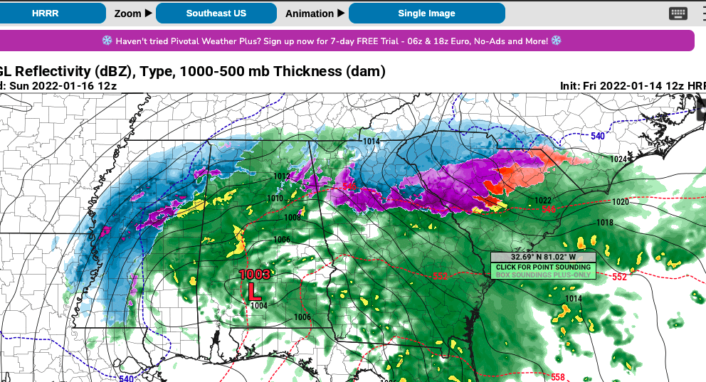
Indeed. Do you trust the long range HRRR Burrel?
-
7 minutes ago, buckeyefan1 said:
Happy New Year!


That's actually a perfect map for about 90% of our actual events. Higher mtns and NW Peidmont with the highest totals, snow line to about the NC/SC state line, and everything else I40 and North. Welcome to winter in the SE!

-
3
-
-
1.26 for me, driest month in years. Stil over 56 in for the year so no drought here.
-
Been disappointed with my temps the last couple mornings; 37.1 and 38.8; no frost. Most areas around me, even South have been significantly colder; I think that northern upstate thermal band effect that happens sometimes has been at play... or something has.
-
6.24 in rain for August, nearly 42 in for the year.
-
5 hours ago, yotaman said:
I highly doubt that map. I don't think I have ever seen 50's in early Sept. in my area. Mid to late Sept. yes but not early.
It's probably overdone and may not happen at all, but man it's nice to see a cool off show up repeatedly. Once we get to Sept summer's days are numbered, no matter what 2018 and 2019 have to say about it!
-
-
A whopping .11 yesterday!

-
GSP topped out at 92 yesterday; forecast was 97. Highest for the heatwave was 95. Hot, but overall, not as bad as predicted. If that is our worst of the summer I can handle it.
-
9 hours ago, WinstonSalemArlington said:
Early August relief
Need that blue to creep on down to SC!
-
1
-
-
On Friday Death Valley reached 130, Needles 120, Vegas 116; all day records.
On Saturday Death Valley reached 129, Needles 122, and Vegas 117. All daily records with Vegas tying its all time high.
-
127 at Furnace Creek, 120 at Needles and Bullhead City.
Forecast low of 104 at Furnace Creek tonight!
-
Now 123 at furnace creek at 12:20pm. DP 46 so real feel is 130!
Also 112 at Palm Springs, 111 Needles and Vegas.
-
Already 111 at Furnace Creek Death Valley at 8:50am. Forecast of 130 today!
-
2 hours ago, magpiemaniac said:
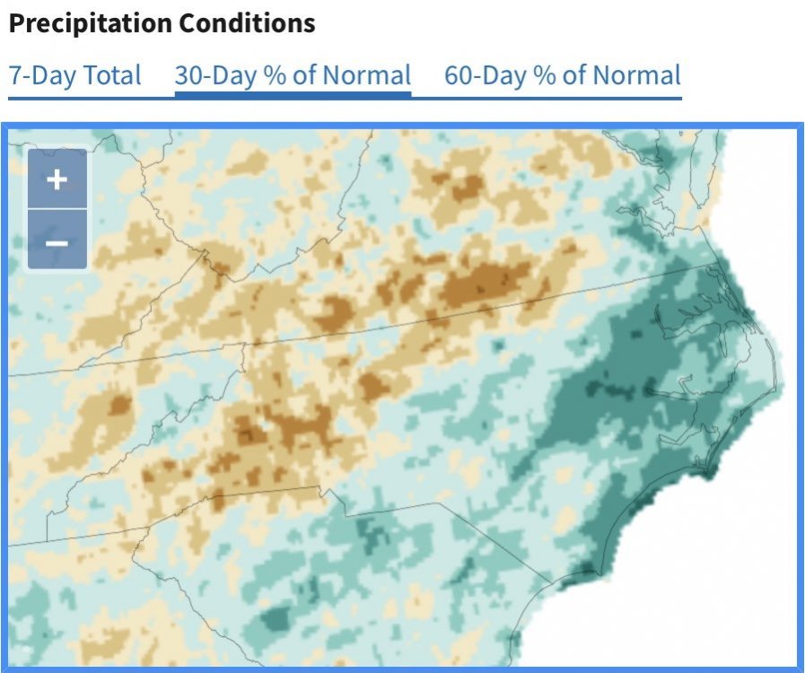
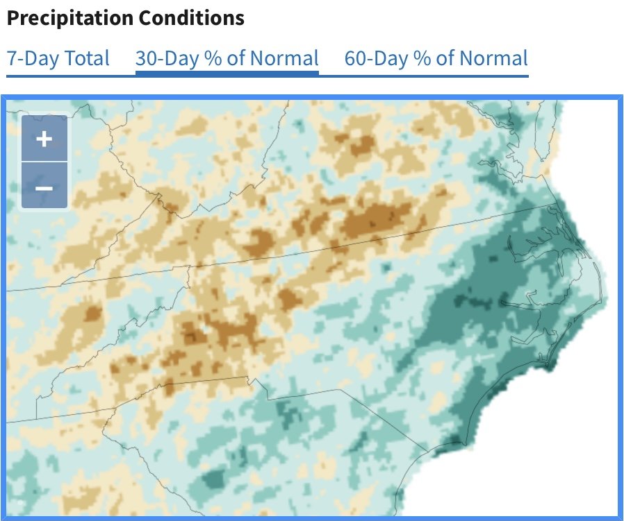
For weeks now, I’ve been used to storms coming from the southwest and dropping the most intense rain to my west and east. I’ve been in a dry corridor. I assumed that since this week’s front is approaching from the northwest there’s no way I could miss out on a good soaking rain. But the models are hinting otherwise. Most of the intense rain will form to my east after the front passes. I’ll end up with a 0.20” light shower of Friday while the Triangle will end up with 2.20”. You might think I’m joking, but just wait and see.

The updated 30-day and 60-day precipitation map shows how dry the western areas of NC and SC have been compared to the east.
Meh; 3 plus years of constant monsoon - this a blip I'm happy for. Still just over 3 inches for the month, and over 30 for the year, which is still above avg for mby.
-
No 90s showing up in the 15 day!

-
Nearly 5 inches of rain brought my yearly total to 26.88 through May. Still fairly wet but much MUCH better than last year when nearly 13 inches fell in May and I had 52.45 inches by the end of the month! I was also able to avoid the dreaded 90 here IMBY, got up to 88.7; low of 40.1. Very nice spring all things considered.
-
You guys must have had a lot less rain than me. I've only had about half the amount of rain through May that I had last year but it's still above average. After nearly 3 and a half years of nothing but rain on top of rain I have been happy for the drier past two months, though I still had nearly 5 inches last month.
-
2 hours ago, buckeyefan1 said:
What an absolute beautiful day with a high of 70 after a morning low of 57
Indeed; probably the best Memorial Day weekend weather of my lifetime!
-
1
-
-
Gonna open the windows back up this weekend, 50s showing again at night!
-
This just says Columbia, but I guess it's CAE:
Jan 56.8 34.6 45.7 3.49 0.6 Feb 60.8 37.3 49.1 3.39 0.4 Mar 68.3 43.6 55.9 3.57 0.1 Apr 76.7 51.5 64.1 2.83 0.0 May 83.8 60.5 72.2 3.49 0.0 Jun 89.7 68.6 79.1 4.97 0.0 Jul 92.7 72.0 82.4 5.35 0.0 Aug 90.8 71.2 81.0 4.65 0.0 Sep 85.7 65.3 75.5 3.91 0.0 Oct 76.5 52.7 64.6 3.13 0.0 Nov 66.4 41.6 54.0 2.76 0.0 Dec 58.9 36.5 47.7 3.70 0.1 Check out USC Downtown!

Jan 59.6 36.7 48.1 3.84 0.2 Feb 64.1 39.7 51.9 3.54 0.0 Mar 71.8 45.8 58.8 4.11 0.0 Apr 80.6 53.6 67.1 2.92 0.0 May 87.2 61.8 74.5 3.63 0.0 Jun 92.6 68.9 80.8 5.41 0.0 Jul 95.6 72.1 83.8 5.17 0.0 Aug 93.8 71.1 82.4 5.01 0.0 Sep 88.8 65.7 77.2 4.25 0.0 Oct 79.5 54.2 66.8 3.31 0.0 Nov 68.9 44.1 56.5 3.04 0.0 Dec 61.3 38.7 50.0 3.88 0.0 CHS
Jan 60.2 38.9 49.5 3.37 0.2 Feb 63.8 41.6 52.7 3.05 0.1 Mar 70.1 47.3 58.7 3.35 0.0 Apr 77.1 54.5 65.8 3.29 0.0 May 83.6 63.0 73.3 3.32 0.0 Jun 88.5 70.4 79.4 6.21 0.0 Jul 91.3 73.7 82.5 6.60 0.0 Aug 89.8 73.1 81.4 6.97 0.0 Sep 85.4 68.3 76.9 6.01 0.0 Oct 77.9 57.7 67.8 4.33 0.0 Nov 69.4 47.1 58.3 2.66 0.0 Dec 62.7 41.6 52.2 3.35 0.0


Southern Sanitarium
in Southeastern States
Posted
The saddest part may be that this happens over and over to the western upstate with certain setups. -The Carolina Crusher everyone gushes over was the exact same thing; complete skip job. Greenwood up to CLT big snow, NW upstate flurries. -Feb 2014 huge snow for everyone...couple inches of slop here; and I remember one spot with no accumulation at all. Other storms like Dec 2010 very little. Dec 2018 saw huge snows in NGA, NC, and Eastern upstate up to 1ft. NW upstate... couple of inches. It can be tough. And I'm actually in a much better spot than Burrel for whatever reason.
We've had some wins too; Jan 87, 88, Jan 96, Jan 2011, March 93, and this past week. But we have a ton of misses and it hard to get a big dog.