

Moonhowl
-
Posts
697 -
Joined
-
Last visited
Content Type
Profiles
Blogs
Forums
American Weather
Media Demo
Store
Gallery
Everything posted by Moonhowl
-
I don't get much more snow than the foothills crew here in the tail end of the Swannanoa Valley but CAD is weaker and Buncombe Snow hole helped with the ice. Rain has picked up here, sending sleet wishes or anything besides ZR wishes down the mountain.
-
Wow, impressive climb in temps
-
Congrats, just went to 32.2 F IMBY
-
Very light freezing drizzle here, temp has climbed to almost 27 F from a low of 24 F.
-
27 F and nothing coming down at the moment in East Avl.
-
Life in the warm nose would be great right now
-
Have fun!
-
Had to look, still some skiers out there, wouldn't want to drive down that mountain in this. Just started a sleet freezing rain mix IMBY.
-
A wedgie is usually best avoided but there are exceptions
-
Southern Crippler - Get well soon Jimbo Storm Obs
Moonhowl replied to BooneWX's topic in Southeastern States
30 F IMBY in Asheville, a few sleet pellets earlier but nothing since. -
There were some things about the forecast and models that don't make sense to me. Reluctant to say anything other than we will see how it turns out.
-
Southern Crippler - Get well soon Jimbo Storm Obs
Moonhowl replied to BooneWX's topic in Southeastern States
32.0 F RH 45% -
Ha,too bad I won't be able to see your reports, lol. Did split a fare amount of firewood yesterday. Coincidentally, today I am working on the same drainage system as I did leading up to Helene. Some critter decided to start plugging the pipes with mud so I had to dig it up, dang varmits.
-
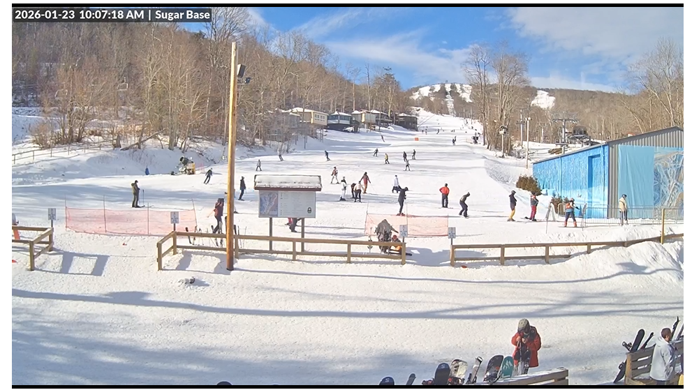
Meanwhile, at Sugar Mountain:
-
I've been through a storm that had 5 inches of nothing but sleet. Not a problem for trees but flat roofs on the other hand...
-
With the 20 degree F freezing rain the NWS has forecast for Saturday night, I guess the top of Mt Mitchell will be having a tropical rain.
-
Not what I wanted to see in the NWS GSP forecast discussion this morning: While the system moves into the area, the colder air appears to get a slight delay in arrival, thanks in part to a developing shortwave moving over the southeast. This could create a brief period of isentropic ascent with moisture lagging, ahead of the colder air. What this does is help to create a warm nose sooner than originally expected. A warm nose means more ice/sleet than snow.
-
Just looked at the NWS forecast for Asheville and saw this: Saturday Night Snow and freezing rain before 8pm, then freezing rain between 8pm and 4am, then freezing rain and sleet after 4am. Low around 18. Chance of precipitation is 100%. Sunday Freezing rain before 1pm Then add wind. This is starting to remind me of Helene. What is the worst case scenario; mother nature says lets do it. Still hard to believe it would be that cold and not be sleet.
-
Winds still cranking here with a toasty 18 F IMBY
-
Congrats on getting some snow! Didn't see a flake IMBY.
-
Enough cold to produce a cold rain for my neck of the woods, oh well, at least I got to see a few flakes last night.
-
Happy Thanksgiving everyone! Get those snow blowers going, hoping to get in some early December
-
2025 Spring/Summer Mountain Thread
Moonhowl replied to Maggie Valley Steve's topic in Southeastern States
The cool down after the storms the past few days has been fabulous. -
Barely a dusting here, wind cranking. Still a little PTSD from Helene, didn't make for a restful night.
-
So your saying not a March 1993 repeat

