

fountainguy97
-
Posts
1,112 -
Joined
-
Last visited
Content Type
Profiles
Blogs
Forums
American Weather
Media Demo
Store
Gallery
Posts posted by fountainguy97
-
-
29.5 and a surprising costing across the deck this morning. HRRR is still the only model giving me any amount of snow with this onset precip. It may score a massive W at this point.
-
 1
1
-
-
-
Hrrr really starting to pull meaningful precip into the valley tmrw morning. Tick tick tick continues.
-
4
-
-
HRRR still ticking flatter (positive tilt) each run. Likely a result of the ULL diving further South.
the more ticks we get like this the better it will get for Eastern areas. I don't buy the HRRR mixing issues right now. It is trending colder by the hour. There will be mixing but I don't think it will be quite as widespread as hrrr shows
-
4
-
-
@Holston_River_Rambler check this out. Notice How the hrrr has steadily ticked more positively tilted over the day. Wonder if this is in relation to the 500mb vort. This could be what is helping easterne areas and getting the deform band across the valley. It's still ticking more vertical each run.
I would assume the less tilted this becomes the further east that deform band ends up.

-
2
-
-
4 minutes ago, Holston_River_Rambler said:
Man this sucker really seems to be digging to me. At the latitude of LA's northern border and still heading SE.
It does look like it is starting to make the turn, but you tell me. Maybe I'm looking at the wrong water vapor level, but it looks SW of where the 18z 3km NAM has it.
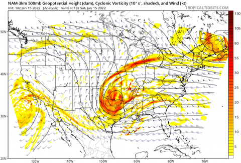
The above gif starts at 1 PM and is in hourly increments.
Definitely seems to still be SSE vs SE. this is when the HRRR comes in handy with the hourly runs. In a game of inches an extra hour of digging is miles and miles of differences.
-
2
-
-
Phew low 20s and that kicker energy bringing the goods. Won't be surprised to see hrrr tick stronger with NW flow post-system. We are still extreme long range for it.

-
1
-
-
Hrrr looks pretty good. What is this enhancement along the TN side of the mountains? Especially in Unicoi county. Never seen a precip maxima like that in my county.

-
This backside band is still 36hrs out. That's still long range for hrrr. I think If we will be surprised by anything it will be that back end and the following piece of energy.
-
3 minutes ago, Carvers Gap said:
Very true. That happens in NE TN all the time, especially Johnson City. Models try to smooth out the transition form the mountains to lower elevations when in fact the transition is quite sharp if looking directly from above. The real pain is when modeling tries to smooth things out between the Plateau and Apps - the distance between the two is pretty narrow up here. I have set the bar at 1" for MBY. Anything else is gravy. With wrecked thermals, downscoping, dry slot, and a low tracking into the Apps....not a great set-up at first glance. Maybe the eastern valley gets a surprise. With cold air not already in place, super tough forecast for the pros.
Yep I'm in the same boat. Tough seeing a lot of 00z and 06z models show 6-8" for me and knowing the cutoff will be way sharper than they are able to show.. I knew this one was a heartbreaker as soon as we went away from the Miller A track. Going to be a LONG day tomorrow watching areas to my east and west get buried and we get the slot.
my one last hope is wrap around NW flow and maybe that kicker energy will help boost that.
-
1
-
-
Don't even have to look at models to know it's not good by how quiet it is in here lol. 12z kept hope alive but 00z is literally raining on the parade. Think it's time to throw in the towel east of the plateau.
edit; wow nam and hrrr have slaughtered snow totals for this event. Reserved to the absolute highest peaks of Western NC.
-
This trend toward RGEM at 850mb is where it counts. Eastern areas will like this run.

-
1
-
-
12km nam through 33 has shifted the surface low south. On the surface its exactly like older RGEM. still a little north of rgem at 850mb.
-
18z hrrr looks extremely similar to RGEM/CMC camp through hr 36 at the 850lvl, Much further south than NAM which is now the outlier of the high res models.
It's precip shield is still mostly south of TN but it has ticked north this run. It's long range HRRR so wont be surprised for it to underestimate the Comma
-
2
-
-
The UK from last night also shows a more traditional Miller A...
-
2
-
 1
1
-
-
4 minutes ago, Weathertree2 said:
The whole system seems disjointed
Yeah it is all in that transfer. You can see how much more solid of a precip shield the CMC has vs GFS. all because of the transfer.
We are losing Western TN with this type of setup though.


-
hmmm cmc... no transfer like RGEM. They are related so no surprise.
-
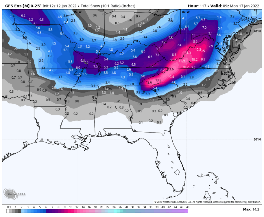
GFS packs on an additional 24hrs of NW flow. Stacks up additional 6" across mountains. Thanks to the kicker energy
-
2
-
-
RGEM shoves the 850 Low abt 100 miles east of other models. Because of this the Surface low never splits up into TN. Instead it shoots off to the east. This pulls the back deform band across Eastern TN instead of dryslotting. Similar to some EURO solutions recently. The problem is this robs Western areas of the deform band pivot. So while Eastern TN is better off with more qpf the western portions are much drier.
Major outlier for now.
-
5
-
-
4 minutes ago, Holston_River_Rambler said:
I've never seen one of these Miller B transfer types in my location, so will be interesting here. The more amped it is, the more it really wants to run an 850 circulation up the eastern valley.
It's not just temps either. Massive dryslot runs right up the gut of Eastern TN as the transfer occurs. Deform band crushes to the west. So the way I see it not only are we fighting temps but also the unavoidable downsloping that will probably show up even more pronounced on high res.
For Eastern TN I wouldn't be hopeful for much action at all this weekend unless we get a decent track shift.
-
3
-
 1
1
-
-
Euro is so tempting but I'm just not going to bite here tucked into the west side of the Appalachians. A LOT of things can severely impact snowfall from an event like this here. I'm not biting until it's go time.
-
6
-
-
lol

-
 2
2
-
1
-
-
9 minutes ago, Vol4Life said:
GFS ensemble isn’t bad either...I’d take this in a heartbeat!
This is actually the best mean for most of TN and KY the gefs has spit out so far. For TN it will come down to how much moisture is associated with the ULL and first low. When the transfer happens we dry up fast besides some back side snow showers. The 12z GEFS has a significant increase in snow across TN Sunday morning. Fingers crossed that ends up being the case. I'd rather not sit in a dry slot for 30 hrs haha.
EDIT: Honestly, we arnt in a terrible spot to make something out of seemingly a disaster trend. The EURO is still south. and GFS is very north. I'll take us being in the middle of those two at this point any day of the week. We wont be looking at a gnarly foot+ across the state but we could see another large swath of 6-7 inches if the cards shake out right.
-
4
-
 1
1
-
-
9 minutes ago, Carvers Gap said:
Trends at 0z are important. I don't think we will see modeling step back towards a major hit.
Agree on all points. I do hold out a glimmer of hope as the Euro op at 6z looked more favorable in terms of location and wasn't as wrapped up. EPS has more members going hybridB though the mean also looked weaker which we need. That is the first time during several runs in which I have seen modeling hiccup.
Definitely still hope. But some GEFS at 06z actually never even transfer really. Just a gut punch up the spine of the apps. The gfs may not be insanely out there in la-la land
-
1
-


Jan 16-17th Boom or Bust
in Tennessee Valley
Posted
30/28. Flake size increasing and mostly snow now. Started as a mix with sleet I assume now the column is saturated. All this is gravy in my book this morning.
roads covering instantly