

fountainguy97
-
Posts
1,029 -
Joined
-
Last visited
Content Type
Profiles
Blogs
Forums
American Weather
Media Demo
Store
Gallery
Posts posted by fountainguy97
-
-
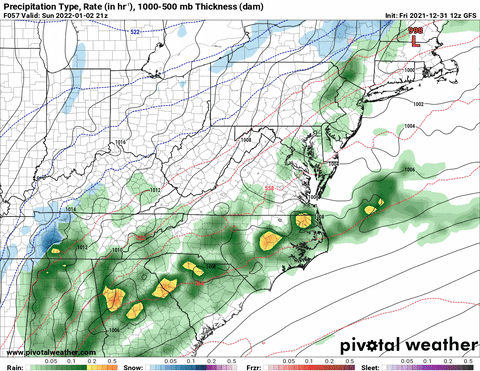
40.6 here. Big dry slot moving in. Hopefully this will pivot back out.
-
Massive bright banding across Morristown Newport and up to Kingsport. changeover in those areas shortly!
-
 1
1
-
-
Just now, Wintersnow888 said:
Once the sleet started here in Cumberland it didn't last long, snow filled in fast
Hope you all get the same in the valley!
I was wondering this. Hrrr has us going straight rain/snow basically. Good to hear that's the case more or less.
-
1
-
-
Just now, Carvers Gap said:
We are a wild bunch. 24 people logged into the sub-forum as we speak at 2:30AM to work a snowstorm. LOL. Awesome!!!
I got my 2.5hrs. I'm ready to roll! Haha
-
1
-
 1
1
-
 1
1
-
-
Hrrr and rap holding with 11-12" falling here in only 5-6hrs. Should see rapid changeover for Eastern areas over the next 1.5hrs. The fun should begin!
latest hrrr has a couple hours of 3" rates for me.. hoping it is right!
-
4
-
-
I think the entire valley is going to basically flash over change at the same time. Can see the CC wrapping around in a circle around KMRX. Probably still a couple hrs from any switching. Hrrr has me switching between 3-4am going to try my best to get a couple hours of restless sleep before haha
-
3
-
-
20 minutes ago, Blue Moon said:
Near Fairview
18z hrrr had your area changing to all snow around 8pm. Energy is tilting negative and back building. You should be good for a few hours of decent rates!
-
1
-
-
You guys think this is all snow for eastern areas? Usually when you see the maxed out blue it's bright banding mixing.


-
1
-
-
11 minutes ago, Dsty2001 said:
So...is it time for us to get excited yet? lol
Not seen a thread with this good of potential not blow up or maybe people are just tired of being burned by the models
12z tmrw I'm biting. 00z tonight every model but NAM I hit the 12" mark on kuchera. If that's the same tmrw at 12z I'm jumping on the train.
If models are correct and I get 10-12" of snow in 6-7 hours it will by far be the most intense storm I've ever seen.
-
Man hard not to get excited here in Unicoi county. But hrrr definitely has some bright banding going on the first couple of hrs. So the snow is probably a little lower than kuchera.
-
1
-
-
It's a beauty.

-
2
-
-
Hrrr lining up exactly like RAP

-
4
-
-
Look at that band. Crawling across TN

-
1
-
 1
1
-
-
Just now, Holston_River_Rambler said:
In regard to soil temps, I will say that they seem to be able to crash back down pretty quickly (12/18 - 12/20)


Oh yeah. Sure it's not ideal and we will lose some accumulation but this isn't 12hrs of .5" rates. The heavy rates plus diving temps. Ground will be white before you know it.
-
1
-
-
This escalated quickly.


-
5 minutes ago, Carvers Gap said:
We really need to add a wow button. No idea if that occurs, but that run is impressive. Mountains may get hammered.
We do haha. 3-4" hr rates on alot of models. Usually we deal with 12+ hr storms but this one entirely falls in 6hrs. Ground temps won't matter much with rates like that as well as the rapid freeze into the low 20s
Someone could very well end up with near blizzard conditions.
-
What do I have to do to get this to happen? 7" in 2 hrs

-
1
-
-
9 please


-
1
-
1
-
2
-
-
2 minutes ago, Holston_River_Rambler said:
Really nice vort pass for eastern areas on the 12z GFS:
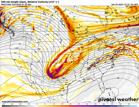
man that band wrapping up around a 999mb low would be crazy.-
2
-
-
Gfs 18z more southern separation. Gets a little tilt on the southern end and boom back to the snowier solution. This is kuchera as well.
A bit more tilt and it's a major major event.

-
1
-
-
Gfs reversing course this morning. 12z will be interesting. Kind of surprised about how slow the boards are about this event. A non-zero chance of atleast flurries for a decent size section of the SE.
GFS has been very consistent with a threat. I'd rather have it on my side than EURO right now.


-
2
-
1
-
-
-
The FV3 is vicious. I've noticed it likes to go supercell crazy though. HRRR and NAM have much more of a linear storm mode vs discreet cells.
but man this fv3 supercell is nasty.

-
1
-
 1
1
-
-
I'm not saying there is a chance but.... most GEFS members bring a NW event on the tail end of this mid November system.
still way out in no man's land for now .


-
4
-


TIMS model verification, December 31, 2021 - January 3, 2022
in Tennessee Valley
Posted
Right on cue as others. 39.7 and seeing bouncing sleet off the deck.