

ryanconway63
-
Posts
479 -
Joined
-
Last visited
Content Type
Profiles
Blogs
Forums
American Weather
Media Demo
Store
Gallery
Everything posted by ryanconway63
-
NAM at 60 weaker and further South
-
This storm would Juice up qpf totals as we get within 48 hours..... the totals seem really low for a storm that lasts sunday morning through mid day tuesday. Somebody between NYC and Norfolk will score big in this setup.
-
Chance we see some Blizzard Warnings with this storm??
-
Faster transfer....this is hopefully good news
-
CMC is very nice.....really nice snows Monday PM through Tuesday Morning
-
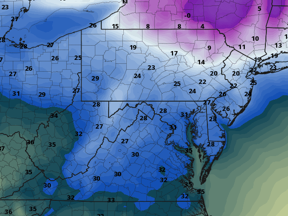
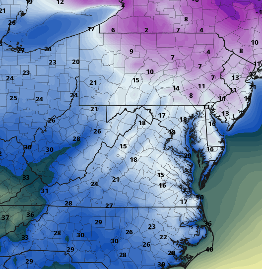
I found this interesting. GFS 2m temps Sunday morning vs RGEM 2m temps same time.
-
baby steps..... loving the Cave to the Euro Mon/Tues
-
Definite Cave to the Euro as far as the progression of the coastal on Monday afternoon. Would love to see that primary pushed down around Kentucky. I think the CMC run will be nice....
-
The primary looks in the same position to me at 84 that is was in the 6z run...maybe even 20 miles northwest. If you look at the previous 6 runs of the gfs at hour 90 there are improvements but still nowhere near the EURO solution.
-
not going to be any changes to the GFS.....Cant believe it hasnt started to buckle to the Euro yet.....
-
RGEM was a nice look
-
No improvements on the ICON from what I can tell
-
Any thoughts on why the Euro Op has been consistently west of the Euro Ensem the past several Runs
-
seems to be some slight tics East since the 12z runs..... starting with the 12z Euro Ens, now the 18z Euro Ens and the NavGEM for what its worth.......all just noise at this point
-
anybody have the control ?
-
looks like an ideal track
-
how does it compare to the 12z run? any slight changes?
-
What does this mean?
-
looks about the same to me
-
thanks!
-
Do you have the 18z Monday map. Was curious at how the clusters tracked.....Looks near ideal.....
-

January Storm Term Threat Discussions (Day 3 - Day 7)
ryanconway63 replied to WxUSAF's topic in Mid Atlantic
its a northwest bump from the 00z -
January Storm Term Threat Discussions (Day 3 - Day 7)
ryanconway63 replied to WxUSAF's topic in Mid Atlantic
looks good so far, no major changes i can tell -
January Storm Term Threat Discussions (Day 3 - Day 7)
ryanconway63 replied to WxUSAF's topic in Mid Atlantic
looks the same through 78 -
January Storm Term Threat Discussions (Day 3 - Day 7)
ryanconway63 replied to WxUSAF's topic in Mid Atlantic
FWIW I know most in this forum don't care about tomorrows event but it did do its typical jog north in the last 24 hours with the precipitation field. Something to watch if you think you are fringed this go round....


