

ryanconway63
-
Posts
479 -
Joined
-
Last visited
Content Type
Profiles
Blogs
Forums
American Weather
Media Demo
Store
Gallery
Everything posted by ryanconway63
-

Jan 31 - Feb 1 Event - STORM MODE THREAD
ryanconway63 replied to stormtracker's topic in Mid Atlantic
So RGEM and ICON have had similar idea so far....interesting....RGEM is going to be the extreme but what a beautiful run it was -
Jan 31 - Feb 1 Event - STORM MODE THREAD
ryanconway63 replied to stormtracker's topic in Mid Atlantic
Does anybody buy the low position just off VA beach at hour 60....that would be historic if it could verify -
Jan 31 - Feb 1 Event - STORM MODE THREAD
ryanconway63 replied to stormtracker's topic in Mid Atlantic
Hugging the RGEM..... Heavy snow in Ches Bay at end up run Tues night, lol -
Jan 31 - Feb 1 Event - STORM MODE THREAD
ryanconway63 replied to stormtracker's topic in Mid Atlantic
NAM southeast and a bit faster compared to 6z at 19 hours -
Jan 31 - Feb 1 Event - STORM MODE THREAD
ryanconway63 replied to stormtracker's topic in Mid Atlantic
Models have definately hurt MBY in Northern neck of Virginia the past 12 hours.....Was looking at a solid 6-8 event now getting fringed and will be lucky to get 2-3 but guess I should have expected that -
Jan 31 - Feb 1 Event - STORM MODE THREAD
ryanconway63 replied to stormtracker's topic in Mid Atlantic
hi bob welcome back -
Jan 31 - Feb 1 Event - STORM MODE THREAD
ryanconway63 replied to stormtracker's topic in Mid Atlantic
Euro come out around 7? -
Jan 31 - Feb 1 Event - STORM MODE THREAD
ryanconway63 replied to stormtracker's topic in Mid Atlantic
tries to pivot back at 72, just have to laugh at it at this point. it tried....should be a better model by 12z tomorrow for what happens during the day monday -
Jan 31 - Feb 1 Event - STORM MODE THREAD
ryanconway63 replied to stormtracker's topic in Mid Atlantic
yea NAM after 48 take with grain of salt -
Jan 31 - Feb 1 Event - STORM MODE THREAD
ryanconway63 replied to stormtracker's topic in Mid Atlantic
yea weird looking frame for sure -
Jan 31 - Feb 1 Event - STORM MODE THREAD
ryanconway63 replied to stormtracker's topic in Mid Atlantic
transfering at 54 -
Jan 31 - Feb 1 Event - STORM MODE THREAD
ryanconway63 replied to stormtracker's topic in Mid Atlantic
NAM worth looking at through 48......after that I wouldnt take it too seriously....unless its a HECS....then hug it of course. -
Jan 31 - Feb 1 Event - STORM MODE THREAD
ryanconway63 replied to stormtracker's topic in Mid Atlantic
What model do we like best for 42-78 hr time frame.....i know most dont take the NAM too seriously past 48 hours.. -
Jan 31 - Feb 1 Event - STORM MODE THREAD
ryanconway63 replied to stormtracker's topic in Mid Atlantic
LOW is 200 miles NE at 18z Monday compared to prev run -
Jan 31 - Feb 1 Event - STORM MODE THREAD
ryanconway63 replied to stormtracker's topic in Mid Atlantic
Im on western side...Northern Neck of Virgiinia....ive seen it happen in past storms in VA beach where the storms cranks and winds flow from due north down the bay and create bay effect....things have to be just right.... -
Jan 31 - Feb 1 Event - STORM MODE THREAD
ryanconway63 replied to stormtracker's topic in Mid Atlantic
Would this be a setup for possible Bay Effect or Enhanced Snow for folks in the Virginia Chesapeake Bay Region. Only seen it happen once in a significant way and it was a similar setup maybe 20 years ago. The storm was pulling away, Mets called for Snowshowers and locations along the bay got an additional 6 inches of of heavy snow. -
Nothing.....You will do fine....I was more or less referring to folks Northwest of DC that have been in the bullseye for many runs see the bullseye push South. Also the Euro shows the system pulling away Monday afternoon, where some other models including the Euro had shown it hanging around another 12 hours.....Just minor stuff at this point. I hope everybody in the forum gets a 6+ event
-
Most in this forum should score nicely...... The takeaway from the Euro I see is definitely a bump east and more suppressed look. Overall its probably a win for people like me in Northern Neck of Virginia but for folks NW of DC i can certainly understand their concern. I do believe there will ultimately be a bump North in the guidance as we get under 48 hours. It almost always happens. Even happened with the event on Thursday.
-
Big Run for the Euro tonight.....unfortunately ill be asleep.... Its been locked in for 5+ runs now....wouldn't expect much change...
-
GFS seems like it is having a nightmare time with that primary low..... i guess we should expect that
-
still snow on the ICON in eastern VA Wed morning....unreal
-
We need to Call Paul Kocin in to bring this one home and do some analysis
-
ICON started to finally cave to the Euro....It will match it by 12z tomorrow....
-
FWIW NAM 84 Hours
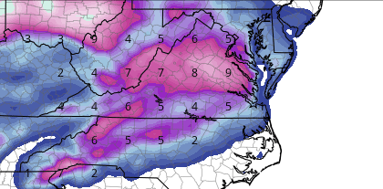
-
NAM South, with Moderate to heavy snow breaking out in VA at 66


