MattHugo81
-
Posts
14 -
Joined
-
Last visited
About MattHugo81

- Birthday 04/23/1981
Recent Profile Visitors
2,378 profile views


-

Some Thoughts On The Next Couple Months
MattHugo81 replied to OHweather's topic in Weather Forecasting and Discussion
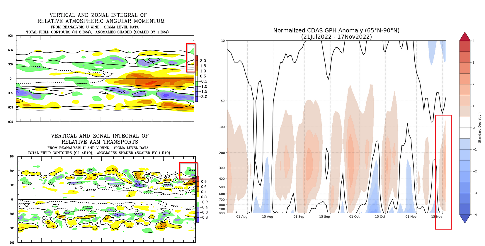
Hi to all. Hope you don't mind me continuing the discussions on here... We seem to be seeing some of the above comments from a week or two back playing out now (no surprises guys!) and it'll be an interesting watch. The extreme -EPO doing the early 'winter goods' across the USA of late but that rise and recovery to more neutral levels seems to be on the way. The feature of interest for the UK and the N Hem as well has been the lack of any progression towards a more blocked pattern sooner than was expected. The EC Seasonal, for example flipped the NAO firmly negative to positive in the blink of an eye and the wait for the early blocking signals have been long overdue, but we seem to be getting somewhere now. A few key features that are standing out are changes in the AAM profile of late, with more E'ly AAM anoms now appearing through the mid-lats, a reversal of recent weeks, while the all important AAM transports plot highlights a clear change as well through the mid-lats. While the sPV continues to 'do its thing' there is clearly no significant connection at all, as you guys have highlighted most recently as well. Clearly, it can be that time of year now through the RI period that a quick downwelling of strong W'lies just over takes anything else and, for the worst case scenario for the UK, the next 4 to 5 weeks simply becomes locked into a +ve NAO regime as the usual deep cold Canada air floods into the W Atlantic and game is over. Clearly, that isn't the case as the below plots highlight... What interests me moving forward is how the MJO evolution, which looks a solid 4-5-6 progression, perhaps into 7 too, could well have on the pattern deeper into December. This is something I think was originally mentioned in this thread, about the next MJO passage. It is also interesting to note that the IOD seems to be trending more neutral as well, but clearly there is always a lag here. It will be very interesting to see how this next MJO wave progresses. I do have a feeling as well that these are the early signs that La Nina is on the way out and clearly, the more favourable phases of 6-7-8 through late Nov and Dec would be extremely interesting indeed. While I can't post the images directly (there's too many nosey people on the internet) I've seen a few recent runs of the UKMO GloSea output for 60N 10hPa zonal mean winds and there has been a sudden shift, but with increasing consistency, for zonal winds to quickly drop away through the second half of Dec, with a number of members bringing about a late Dec/early Jan SSW. The seasonals have all been about early winter blocking and I still fully expect that to come to fruition now and, finally, should hopefully kick this damn N Atlantic trough to touch, for a while, or least help relocate it. Without jumping the gun too quickly though, could it well be a winter season whereby the primary caveat for sig changes to the outlook is heavily reliant on a significant SSW but one we are potentially seeing the building blocks for come into place now and of which could well mean a very different outcome through January/February than what the seasonals have long predicted. As ever time will tell, but there's definitely "something" about this winter now that is spiking my interest after viewing the blocked signals from the seasonals for the last 3 months or more. Cheers, Matt.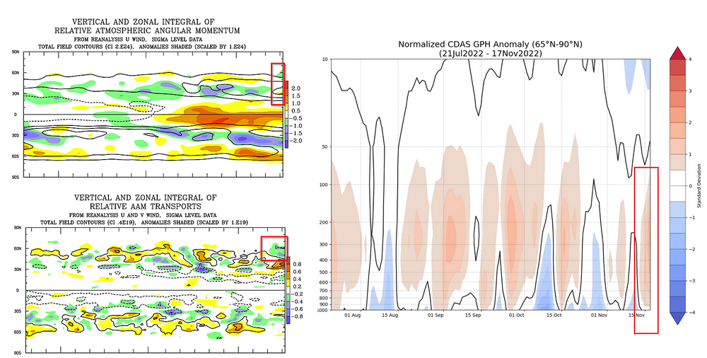
-
Some Thoughts On The Next Couple Months
MattHugo81 replied to OHweather's topic in Weather Forecasting and Discussion
Thanks for taking the time to post this information... The blocking signals for the early part of the winter period have been consistent, not just related to seasonal model data, but with regards to the key drivers and teleconnections as well. However, we have all been here before over the years and I fully believe now that LRF is becoming an even more difficult task due to the influences from climate change. We've seen some 'strange' behaviour of the QBO in recent years, while analogues and composites still provide interest I believe it is these which are becoming increasingly unreliable when looking ahead. Perhaps one could suggest that has always been the case, but I certainly believe their usefulness is being counterbalanced by climate change influences. From a Europe and British Isles perspective it has been interesting to see how the +AAM spike/high GWO phases now have helped to push back a more anticyclonic trend and aiding to maintain the trough over the N Atlantic. The flatter pattern, which you discuss and of which is highlighted well on some of the plots shows this. It is certainly interesting to see one of the highest AAM spikes in nearly a year within a well entrenched La Nina (oceanic) regime. Clearly, at the moment an atmospheric and oceanic disconnect which is interesting in itself. As you also highlight nicely, it does look as though that Maritime/W Pacific tropical forcing will be a key feature of Nov and Dec, perhaps the winter as a whole as well. Having the MJO in phases 5-6-7, overall, will certainly be interesting for early winter period, clearly phases that often promote amplification to the N Hem pattern (https://www.meteonetwork.it/models/mjo/) but clearly this is one piece of the jigsaw. While N American can often see cold from more muted signals, unlike the British Isles which often needs a far more robust -ve AO and NAO regime, from my experience over the years it is often the development and interaction of the sPV and the tPV that can 'lead the winter dance'. If the sPV becomes a dominant feature and of which links to the tPV then, "9 times out of 10" it is curtains for any sort of meaningful -ve AO and NAO pattern which has been exampled well in the last couple of winters. Fortunately, at the moment, despite an increasingly organised feature, there remains little evidence for any rapid connection of the two. Also, we need to keep a close eye on the persistent block that is modelled over Scandinavia and potential wave breaking influences down the line as well. A case of 'steady away' for now, but again as you have highlighted well in the original post, there is a lot of hope and also science being this winter being far different than last year, for example and perhaps especially so over the next 8 weeks. The latter half of the winter period would likely transition to a +ve NAO pattern, IMO, at the moment, but clearly that depends on any SSW risk and potential down the line. Kind regards.