

JC-CT
-
Posts
17,866 -
Joined
-
Last visited
Content Type
Profiles
Blogs
Forums
American Weather
Media Demo
Store
Gallery
Posts posted by JC-CT
-
-
Just now, RUNNAWAYICEBERG said:
For sure. And a few weeks ago the slight coating of ice in the morning caused all of wct roads to be impassable, accidents everywhere.
right. treated roads should be fine, but untreated ones, watch out.
-
1 minute ago, RUNNAWAYICEBERG said:
They close schools here for flurries thesedays so just a mention of icy conditions possible will shut the entire town down.
it's not the most ideal timing
-
Did BOX just decide not to do AFDs today?
-
-
6 minutes ago, Damage In Tolland said:
I think most folks here realize the cold press will win. They always rip in faster than even the coldest models show. Just a suspicion, but the folks calling for all rain dews and full pack loss are going to be doing some WTF’s come Friday morning
Even the coldest meso (ARW) gives you 1" of rain before flipping to below 32 at the surface.
I also haven't seen folks calling for "all rain" but maybe I missed it.
-
 1
1
-
-
Just now, dryslot said:
Looks like the 12z Euro is going to tic south here
we press
-
 1
1
-
-
Just now, powderfreak said:
The Ensembles have been pretty damn consistent for 3 days now.
12z GEFS 6"+ probabilities. BUF to BTV to BML steady as she goes.

That definitely looks north of the first time I recall you posting it though.
-
4
-
-
Interesting that the herpes definitely sees more cold than its big brothers


-
1
-
-
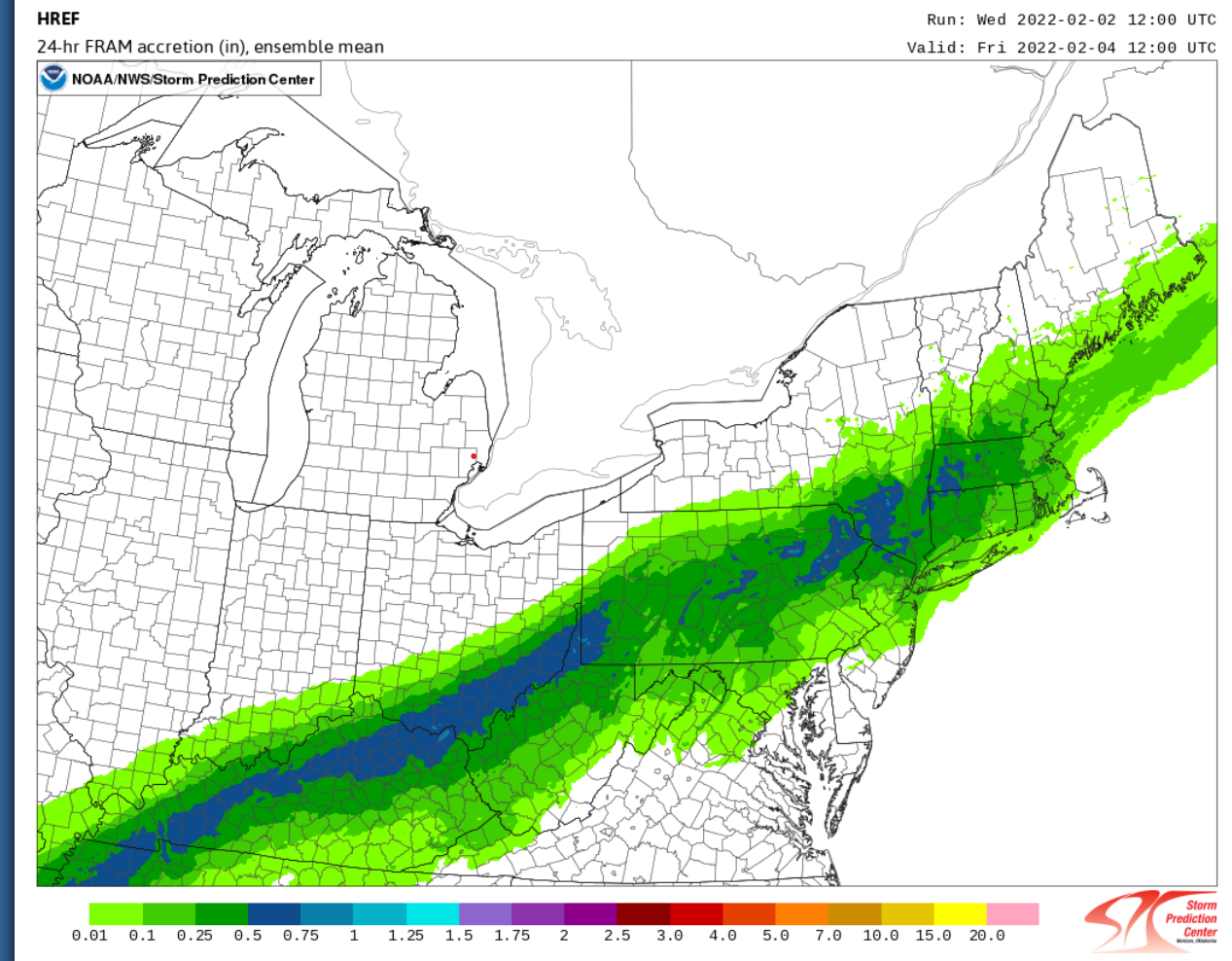
4 minutes ago, JKEisMan said:
href ice potential

It's also not done by then
-
3
-
-
Just now, dryslot said:
When i see these warm post i think the front is still in Canada.

-
Just now, Typhoon Tip said:
Hey JC' ... do you have the top panel at the 850 mb by any chance ( same prodcut source ? )
That's not the 3rd image?
-
Just now, RUNNAWAYICEBERG said:
We'll see how the rap performs. it does zr/ip quite a bit after 1" of rain but we're also still digging out from it's Saturday performance out here when it was dumping 18-24" at nowcast time.
Sure, I'm just pointing out a model that happens to show the scenario
-
1
-
-
-
11 minutes ago, ORH_wxman said:
Yes, I did mention that....and we often see late shifts north on these. The most "interesting" aspect of the storm in SNE is now all about the frontal boundary at the surface.....if we meso-low this thing with a finger of low pressure over the Cape and into the waters east of BOS, then it's going to be a lot of icing (sleet may cut down though?)..
15z RAP shows you how it's done. Cold air from the north, meet warm air from the south. Hello ice. Tolland-approved.
-
2
-
-
1 minute ago, ineedsnow said:
actually much colder
needs to be put in the context of how much a complete torch it was at 0z/6z, or it's not particularly useful information. The most extreme model on either side should be expected to adjust towards the center.
-
2
-
 1
1
-
-
4 minutes ago, CoastalWx said:
There is considerable variety with the 12z hi res models.
the ARWs would be interesting everywhere. Everything else is pretty meh south of the pike...maybe FV3 is interesting north of the CT border. Would be pretty sweet if the ARWs scored a coup here
-
Just now, Ginx snewx said:
Perhaps you should go back to questioning Kevin about his snow totals based on incomplete observations from nearby reports. Enjoy your mud it's the only mud you hot.
I publicly apologized to him for that. But keep talking about others taking pot shots, old man.
-
 1
1
-
-
Patience, grasshoppers

-
2
-
5
-
-
1 minute ago, ineedsnow said:
meh we will see what the rest of 12z does but HRRR is also colder
HRRR is pretty similar to FV3 - in the middle of the ARW and NAM
-
1
-
-
3 minutes ago, JC-CT said:
hmmm


FV3-HR is somewhere in between

-
-
Just now, dryslot said:
Nams garbage here.
It is...wondering if it is a little overdone though
-
1 minute ago, Ginx snewx said:
JC the Rodney Dangerield of the SNE subforum just taking pot shots at everyone. Kids these days
Oh please do tell me more
1 hour ago, Ginx snewx said:Thread dominated by western CT posters still bitter, angry and downtrodden over missing the blizzard of a lifetime. Posts just bleeding envy. Sad to see
-
1
-
-
kevin's first call was right, should have stuck with it


New England Overrunning Event 02/03-02/04/22
in New England
Posted
and of course, it's hard to treat them when it's pouring rain