

wxdude64
-
Posts
6,752 -
Joined
-
Last visited
Content Type
Profiles
Blogs
Forums
American Weather
Media Demo
Store
Gallery
Posts posted by wxdude64
-
-
21 minutes ago, WxUSAF said:
My grill topper sublimated

It happens
-
 2
2
-
-
7 minutes ago, AmericanWxFreak said:
 4 minutes ago, Weather Will said:
WB 12Z Can.

Certainly some sharp cut-offs
-
19.4/10.6 currently and a few peaks of sun through the clouds. Had some flurries around 9 am. Waiting to see what we get later. Edit- as of this morning running a -7.2 for the month.
-
Dropped to 10ish around 2-3 am, then temps climbed with cloud cover. Currently 13.9/9.0. High was 27.0.
-
1 hour ago, EastCoast NPZ said:
Forecast low of 12F. Low of 17F.
Betting today's forecast high of 28F far exceeds that.
Forecast for overnight was 10. 9.2 was low. So, it was a win here. Currently 16.8/0.9 at 10:30 am.
-
 1
1
-
-
It would be a bundle up morning skiing/boarding at the 'Show this am, -12 degrees currently.
-
1
-
-
Made it into single digits, barely. Currently 9.7/0.8 and clear skies. Low was 9.2 around 6 am.
-
Snow Squall Warning in Garrett County?!?
-
 1
1
-
 1
1
-
-
Just now, nj2va said:
Damn, Caps are rolling. Shutout!

Yeah, my wife (who is from Orange County) was not happy with the outcome lol.
-
1
-
-
15 minutes ago, ravensrule said:
I’ll buy an Iphone, Ipad, Apple Watch and Airpods if this can be guaranteed.
3 minutes ago, StormyClearweather said:Hell, I'll buy the Vision Pro... but only if I get my full 18".
What happens with my Nokia flip phone??
-
The front means business, gusted twice to 39 in last 15 minutes!
-
3 minutes ago, mitchnick said:
And I know just how to fix it.
.jpeg.e3dd2a435028375e27b5a60f13646bd9.jpeg)
No, bring on the Sledge!
-
2
-
 1
1
-
1
-
-
4 minutes ago, pazzo83 said:
yeah looks like N&W of DC (not surprisingly) stayed closer to freezing. It's nice and sunny here with little wind - hence the spike in temps.
Wind WSW at 9 gusting to 22 here now. Been sorta windy all day, although it has been sunny to partly cloudy most of the day.
-
Looks like I'm gonna stay just below freezing for the day, currently at 31.2 degrees after peaking at 31.4 20 minutes ago. Sun already headed below the hill behind house.
-
1
-
-
7 minutes ago, Ralph Wiggum said:
Thanks, but I'll stick to Ovaltine.
A crummy commercial?
-
2
-
1
-
1
-
-
Just now, psuhoffman said:
I just need to make sure everyone knows it shows sleet in central VA just in case they missed it
I know it messes with deep snow totals, but sleet has MASSIVE 'staying power' after it is on the ground. It is a bitch to shovel and plow though.
-
2
-
 1
1
-
-
2 minutes ago, NorthArlington101 said:

That would make 95.8554% of us happy
-
1
-
3
-
-
-
18.4 for current (7 am) and low after a 40.4 high for a short minute. Winds were gusty overnight and currently 9 gusting to 16, making WC 7 to 4 degrees.
-
1 minute ago, ravensrule said:
I hope he is ok. He hasn’t been around at all. Maybe he moved to Buffalo and doesn’t need us anymore. Come back @WinterWxLuvr
He was mentioned a couple nights ago and someone posted they had tried to reach out/ DM them with no response.

-
 1
1
-
-
2 minutes ago, Ralph Wiggum said:
We are an odd bunch. When the GFS shows a rare solution for the deep Southeast we bash it but when it shows a rare solution for our regions we embrace it.
That is IMBY at its finest.
-
1
-
-
1 minute ago, MillvilleWx said:
That’s really impressive for moonlight. Wow
What I thought too! Almost daylight lol. About 4.5-5" on the deck.
-
1
-
-
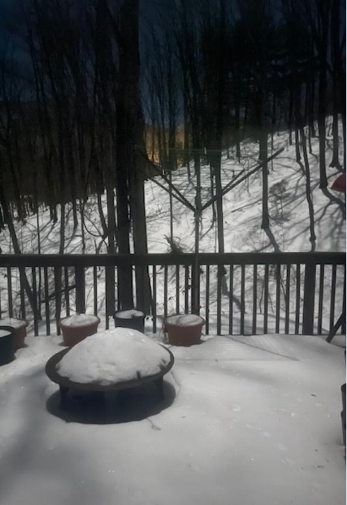
What the bright moonlight looks like here on the snowpack-
-
7
-
-
Hit 40.4 degrees about 2 pm for the high. First 40+ since 1/2. A little snow melt, south facing steep slope is around 1 inch and everywhere else in 3-5 inch range. Currently 37.7/22.4 and mostly cloudy.
-
1
-


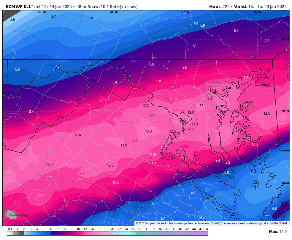
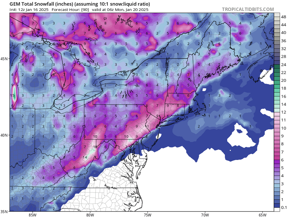
January Medium/Long Range: A snowy January ahead?
in Mid Atlantic
Posted
At least that'll give them a genuine reason to put the gloves, goulashes and heavy coats on instead of upper 40's when that usually happens.....