J.Spin
-
Posts
6,440 -
Joined
-
Last visited
Content Type
Profiles
Blogs
Forums
American Weather
Media Demo
Store
Gallery
Everything posted by J.Spin
-
Winter Storm Sage continued on through Tuesday night, and a resurgence of heavy snowfall came into the area yesterday morning. So, combined with somewhat limited lift service at Bolton on Tuesday due to power outages, yesterday was an obvious day to get out for turns. My younger son was off from school for his second snow day in a row, and since it initially didn’t look like any of his friends would be able to join him for skiing, he and I headed up to the hill to catch the opening of the Vista Quad. Snowfall was probably in the inch per hour range at that point, so the Bolton Valley Access Road was a bit slick, and we encountered a couple of vehicles having trouble on the ascent. Areas up around the ridgeline of the resort were getting hit pretty hard by the wind, so the new snow was heavily wind packed up there, but once you were down a couple hundred feet, most areas were fine. Surface snow depths I measured were generally around 20 inches on the low end, up toward 30 inches on the high end, and that seemed to fit pretty well with the resort’s reported 32” storm total. While the initial forecasts for Winter Storm Sage looked fairly lean in the Northern Greens, accumulations ultimately approached 3 feet, and the snowpack depth at the Mt. Mansfield Stake took a healthy jump up to 90 inches. Winter Storm Sage wound up being a solid storm cycle up and down the spine of the Green Mountains, with roughly 3 to 4 feet of accumulation. The north to south listing of available storm totals from the Vermont ski areas tells the tale: Jay Peak: 28” Smuggler’s Notch: 34” Stowe: 33” Bolton Valley: 32” Mad River Glen: 32” Sugarbush: 29” Middlebury: 24” Pico: 22” Killington: 22” Okemo: 35” Bromley: 36” Magic Mountain: 36” Stratton: 40” Mount Snow: 48” At times on the mountain yesterday, especially late morning, we were getting hit with larger flakes for increased loft in accumulations, but there was still plenty of dense snow present as well. When you’re nearing 3 feet of dense snow like that, the name of the game was still to hit steep terrain for the best turns, so my son and I started off with a run of Vermont 200. After only that one run, we ran into one of my son’s friends at the base of the Vista Quad, and the posse just continued to grow as the morning went on to include another one of my son’s friend, his dad, and then another friend. We found excellent conditions on Cobrass, and Maria’s was outstanding – most specifically the initial steep section due to the pitch being a great fit for the substantial depth of the moderately dense snow. The Wilderness Double Chair was schedule for a midmorning opening, but it wasn’t until midday or so that it actually opened. Wilderness offered up the clear highlight of the day in the form of the headwall of the Wilderness Liftline. That terrain isn’t usually open, because it’s very steep, so steep, ledgy, and exposed to the wind that it rarely holds snow. I’m not even sure if it’s officially a trail. Although the very top is usually roped off by patrol, you can access lower parts of it by traversing in from the surrounding trees. As we passed over it on the lift, it was clear that coverage below the first several yards was excellent, so we traversed in below that point to check it out. It delivered some classic steep and deep, and more than once I heard some of the boys proclaim that was the steepest powder they’d ever skied. Ski patrol clearly felt that the entire slope was safely skiable, and by our next run, the rope was opened and everyone was diving in from the very top. The energy and excitement of the folks on the slope, and those right above you on the lift (the snowpack is high enough that you actually had to appropriately time it to stay clear of people on the lift at the entry) was quite palpable. Although the lower slopes of Wilderness are too shallow in pitch to support skiing in 2 plus feet of dense powder, they did offer another highlight of the day. The parts of the Wilderness Liftline that had been groomed were substantially lower than the surrounding areas of the trail that had not been groomed, so it provided a kicker to use if you wanted to jump into the powder. The boys started launching powder bombs as they threw themselves off the side of the trail, and eventually everyone got into it and was burying themselves silly. It was great fun all around and made for lots of hilarious GoPro footage. Action photography was definitely tough yesterday with the heavy snowfall, but we still our best to document the great outing in one of the top winter storms of the season thus far.
-
In Bolton’s early morning report they were indicating 3 to 4 inches of new snow from Winter Storm Sage, but little did they know, by the afternoon the storm would already have dropped several times that amount. The Winter Storm Warnings from the National Weather Service in Burlington started including counties farther and father to the northern part of Vermont, and that was definitely a sign that the storm was going to have a bit more impact in the Northern Greens than the weather models had initially suggested. Here at our house in Waterbury, the snowfall really started to pick up in the midmorning period. We began to get very large snowflakes with diameters in the 3 to 4-inch range, and those flakes were accompanied by very heavy snowfall rates; over the course about 30 minutes, we picked up roughly half a foot of new snow. Bolton had clearly been hit with similar snowfall rates, and it was obvious that there was far more than the initial few inches when I headed up to Timberline for a tour this afternoon. My depth checks from the Timberline Base at 1,500 feet were indicating 12 to 16 inches of new snow. I wasn’t sure if there was going to be much additional accumulation with elevation, but by the time I hit 2,500 feet, my measurements were in the 15 to 18-inch range. Bolton’s snow report update from later in the day had their accumulations topping out at 18 inches, so that fit well with my observations. The actual skiing itself was rather interesting. On my ascent it was already obvious that the snow wasn’t at all wet at elevation. It was fairly dense though, with small flakes falling during my tour. With those small flakes falling atop the accumulation of the larger ones that would have fallen during that midmorning, the powder wasn’t perfectly right-side-up. It wasn’t exactly upside-down either, but there was an element of that in the powder, and combined with a foot and a half of new depth, it added some extra challenge. When you’re on 115 mm boards and you’re feeling like they might not be wide enough, that’s saying something. While I didn’t personally see anything slide or even slough when I was out on my tour today, I did feel tinges of spookiness of steeper slopes, with part of that coming from the slightly imperfect density profile. It didn’t come as a complete surprise when I saw the following in Bolton’s updated snow report: Urgent Message From Patrol: Avalanche hazard present at this time. If travelling on terrain (especially uphill routes and backcountry) follow appropriate avalanche precautions and gear up accordingly. So, be careful if you are riding in potentially hazardous spots in the near future with this current snowpack. And unfortunately, the best skiing really is on the steepest terrain right now. I could tell on my ascent that I was going to need some serious pitch to get a quality descent, so I dropped in on the Tattle Tale Headwall, and it certainly delivered. We’ll see what the back side of this storm cycle does for the snow profile, but for now, you’re going to want at least black diamond pitches for the best turns in undisturbed snow. Indeed, if you’re planning to head out for turns tomorrow on anything that hasn’t been tracked, bring your fattest boards and hit the steepest terrain you can find. Conditions should be great though, because we’re in the process of getting another massive resurfacing of the slopes, and its already atop a surface that didn’t really even need it.
-
The BTV NWS actually pushed the Winter Storm Warnings north again as one can see on the updated advisories map. They also bumped the accumulations on the latest Event Total Snowfall map. The point forecast here calls for another 8-16” through Wednesday night, so we’ll see how that plays out.
-
I just noticed that they pushed the Winter Storm Warnings farther north again, so that trend continued as you can see from the latest alerts map. And, you can see the additional increases in the Event Total Snowfall maps pushing more of that 12-18” shading farther into the Northern Greens. It’s actually been snowing pretty hard here at the house in Waterbury. The snowflakes have been very large with diameters in the 3 to 4-inch range, and snowfall rates have been somewhere above 6”/hr. We picked up 2 inches of accumulation in about 10 minutes, and roughly another half foot of snow came down in short order Based on the local radar it appears it was from a band that came through.
-
Your thoughts were prescient, because Alexa just alerted me that we’ve been put under a Winter Storm Warning here in Waterbury, and indeed the warnings have move north a bit. Our BTV NWS point forecast currently suggests 6-14” of snow accumulation through Wednesday, with additional snow on Wednesday night, so we’ll see how that goes. I haven’t seen a recent update to the Event Total Snowfall map, but they’ll probably make some adjustments if they are substantial enough.
-
CoCoRaHS likes us to get the liquid equivalent in the snowpack on Mondays, but I only do it occasionally because it’s a substantial amount of extra time to add to the daily routine. That’s especially the case as we get farther into winter with the way the snowpack typically builds around here. I had time for the coring and melting this morning though, and the analysis revealed that there’s currently 5.02” of liquid in the snowpack here at our site. I haven’t run a liquid analysis in over a month, since back in early February when there were only about 3 inches of liquid in the snowpack, but the NOHRSC modeling for our site was absolutely spot on with the numbers as today’s data point and the modeling line show in the plot. The numbers are that tight despite almost a dozen additional winter storms during that period, so kudos to the modelers as usual. As the plot projection shows, the snowpack also seems poised to take on another good shot of liquid equivalent in the coming days. While there was some discussion about it a couple of months ago, I highly doubt that January is going to represent the peak of the snowpack around here this winter.
-
With no obvious fresh snow in the past few days for the Northern Greens, there wasn’t a huge extra incentive to head out for turns this weekend, but as PF noted with his report on the conditions at Stowe, the quality of the snow that is out there on piste is tremendously high. We’ve had a few decent resurfacing events this season, but this most recent series of winter storms including that low pressure from the Ontario/Quebec border passing southeast across the region on the 26th, Winter Storm Piper on the 28th, that quick moving system that came across from the Great Lakes on the 1st, and then Winter Storm Quest on the 4th, has probably been the best. We picked up roughly 30 inches of snow in the span of that week at our site in the valley, and of course the mountains did substantially better than that. Moreover, being the late February/early March period, all that snow came in with a strong snowpack in place, more so than any of the previous resurfacing events. The snowpack at our house currently has 5 inches of liquid equivalent in it, so the mountain snowpack must be absolutely loaded. Suffice it to say, the past couple of weeks has been a setup for great ski conditions. My wife and I found ourselves with some time yesterday afternoon, and the skies were clear with temperatures in the 30s F, so we headed up to Bolton Valley for some on piste Telemark runs at Timberline. The first thing we noticed was that Timberline was a very popular place for a Sunday afternoon, and that was because the third annual Blauvelt’s Banks competition was taking place there. My younger son had mentioned that he’d seen them building the course there earlier in the week, and that was an interesting change of pace because they’ve held it up at the main mountain in the past. This year, the course was on the lower part of Showtime, with an excellent view for those riding the Timberline Quad, and the course looked great. The placement of the course did mean that access to Showtime and Twice as Nice was restricted though. In terms of our ski session, we hit just about everything else that was available off the Timberline Quad. Even after a number of days without fresh snow, the quality of the ski surfaces continues to be fantastic. The snowpack can certainly take a beating as we get farther into spring with those seasonal temperature fluctuations, but even with temperatures edging a bit above freezing, the snow just seems to stay beautifully consistent. Most terrain has soft, winter snow, and even in areas at lower elevations in the sun where the snow was transitioning to a more spring-like surface, it continues to retain that winter-like consistency and softness. You can just lay into every turn and get a beautiful, smooth, quiet carve out of it. We stuck to on piste terrain on this outing, but I did check the snow off piste, and it still seemed quite light and powdery, even down near 1,500’ elevation. It looks like yet another system, Winter Storm Sage, has the potential to affect the area in the next couple of days, and the ski conditions will hopefully continue to be strong because any snow it brings should be going down atop the current quality snowpack.
-
After a couple of great outings in the new snow on Friday and Saturday, I wasn’t really sure if I was going to ski yesterday. I figured the snow would be settling or warming, at least in the lower mountain elevations, and combined with skier traffic, that would bring the conditions down a notch. My older son was still at the house for the weekend though, and when he was eager to get out for some turns, that easily tipped the balance and we decided to head up to Bolton. It was late morning by the time we hit the mountain, and they were already running out of parking spots at Timberline, so people were clearly eager to get out. Once we hit the hill, it was easy to see why. Winter Storm Quest had departed, the weather was pleasant, and the quality of the snow seemed like it hadn’t changed at all. There had been some additional snow on the back side of the storm cycle, but even the earlier snow seemed like it was in great shape. Amazingly, it almost felt like it had dried out a bit more and the powder seemed a bit less dense. We had planned on a mellow day on the Telemark skis enjoying the groomed and packed runs, but that plan fell by the wayside a bit when we found that there was still plenty of untracked powder around, and it was of such good quality. We had a great time touring around the mountain and managed a big loop that hit every lift at the resort and concluded with a big long run down from the Vista Summit to the Timberline Base. Temperatures were very wintry and chilly up above 3,000’, and remarkably pleasant down around 1,500’, but still cold enough to continue preserving the snow. We were most impressed by the durability of the recent snow. The surfaces just continued to hold up with incredibly soft snow and no signs of ice, even in high traffic areas. I know that we’re really skiing on snow from more storms than just Winter Storm Quest, but even the packed runs were just so enjoyable because every turn you took, you could rely on encountering only soft, yielding snow. We’ve reached a point where the quality of the snow is so good that it’s really dropped the difficulty of every trail down a solid notch. Skiing advanced runs feels like skiing intermediate runs, and you can really enjoy the steeps without having to dodge patches of hard snow. I noticed this aspect of the skiing prominently on the steepest pitch going into Maria’s, where tight, high-angle, moguled terrain just seemed to flow because you never had to avoid ice or other obstacles. It was a great day for my son to push himself with his Telemark skiing on challenging terrain, so I’m definitely happy he tipped the scales and got us out for those turns.
-
I’m not sure exactly when the snow from Winter Storm Quest started up around here, but it was well into Friday night, and I’m not even sure if I saw any accumulation before midnight. So, waking up in the morning to find over 8 inches on the boards for 6:00 A.M. CoCoRaHS observations meant that the snow must have been coming down in the 1 to 2 inch per hour range. There were plenty of large flakes falling at that point, and the morning’s liquid analysis revealed that the water content in the snow was 8.5%, or a snow to liquid ratio of approximately 11 or 12 to 1. My older son and I got up to the hill just about the time of the opening of the Timberline Quad, and had a great bunch of runs while we waited for my younger son and one of his friends to join us. During those morning runs, it was quickly obvious that the new snow that had fallen had laid in a massive resurfacing of the slopes. The snow was actually on the dense side due to fairly small flakes, and I’d say it was running a bit above 10% H2O up there. The snow was dense enough that you wanted terrain on the steeper side to really have a good flow on the descent, and that was fine, because in terms of coverage quality, it didn’t matter how steep the terrain was. On piste, off piste, it didn’t matter; just pick the steepest lines you could find, ski as aggressively as you wanted, and you weren’t hitting the subsurface. We tested many of the steepest lines available on Timberline like the Spell Binder headwall and the Tattle Tale Headwall, and they skied beautifully. We hit steep off piste lines that I don’t usually find to be that great because their pitch is often too much for the quality of the snow or achieving bottomless skiing, and it just didn’t matter. In terms of surface snow depths, our checks in the 1,500’ to 2,500’ elevation range were about 15 inches if we had to pick a best estimate, but it was really hard to tell exactly how much snow came from just this storm. The new snow was sitting atop snow from other recent storms, and it all just continues to stack and set up excellent surfaces. It continued to snow all morning, so that kept piling on new snow to the accumulations as well. Total snowpack depth is 40 inches or more above 2,500’, and the snowpack depth at the Mt. Mansfield stake being over 60 inches speaks to that. Later in the morning we met up with my younger son and his friend, and we just went around hitting some of our favorite steepest off piste lines all over the mountain. Timberline had no lift queue for essentially the whole morning, but after about midday, the temperature at those lowest elevations seemed to creep up toward freezing and the snow became even a bit denser. It was somewhat subtle, but you could tell when you skied a run that the powder in the lowest elevations was a bit thicker than it was above 2,000’. After most of the morning at Timberline, we focused on the main mountain for the early afternoon where everything was above 2,000’, just in case Timberline continued to warm and the powder got wet. We joined up with another one of my son’s friends and his dad for a final run on the main mountain before making a big long run all the way down from the Vista Summit to the Timberline Base. Temperatures clearly hadn’t gotten too high to really ruin the powder because it was still fine all the way to the Timberline Base at 1,500’. It continued to snow most of the day, and after a bit of a lull around midday, the snowfall picked right back in the afternoon to the level it had been in the morning, so we knew there was definitely more accumulation on the way. Back down at the house at 500’ that afternoon we could see that temperatures had definitely gone above freezing because some of the new snow had settled, but the mountain elevations seemed to fare quite well with respect to any melting or settling.
-
The season snowfall average seems to be around 160” here according to the data, although it’s a few inches shy of that with the highly anomalous ’15-‘16 season in the small data set. That’s gradually getting diluted though. Here’s the snowfall progression plot for the season thus far at our site: This certainly hasn’t been a standout season on the high side of average, and it’s of course been running behind average pace for snowfall, but it’s certainly been OK. In just my small data set of 16 seasons, there are five seasons that had less snowfall to date than this one. We’re only about a foot behind average snowfall pace, and with a decent storm in the forecast, we’ll probably make up some ground toward average. We’ve had 45 accumulating storms thus far, the snowpack has been in place continuously since early December, and the snowpack depth is at 17”, which is right around average for the date at this site. There were certainly a couple of slow stretches in the first half of January and the first half of February as the plot shows, but the snowpack was in, and there was skiing through all of that (even if the skiing was sub-par). It would take a healthy run to get to average, but the data say we’re well out of the basement seasons at this point.
-
With the latest round of BTV NWS maps, Winter Storm Warnings have expanded all the way to the international border, and the 12-18” shading has made its way up into part of the Northern Greens, so the modeling has obviously suggested some potential in this area. Our point forecast here at the house is in the 8-16” range for accumulations through Saturday, with a bit more after that. There doesn’t appear to be much of an upslope signature on the back side of this storm cycle though, so I wouldn’t expect a ton of extra accumulation. The BTV NWS forecast discussion doesn’t really suggest quite that accumulation range around here, but the modeling presumably picks up the effects of the spine and goes with that. It’s often correct with respect to the orographic boost, but it depends on the system, and we’ll see how this one goes. We’re sort of on the edge of the potent banding around here on some global models, but many of the mesoscale models send that heavy snow right up to the border, so we’ll see how that plays out.
-
We’ve recently come into a snowier stretch here in the Northern Greens; we’ve picked up accumulating snow at our house every day for the past ten days, and over two feet of new snow has fallen in the valley during that period. The skiing has been great, but I haven’t been up to the hill since I was out on Sunday with the boys because I’ve just been a bit too busy. Things were a little lighter today though, and with a modest system affecting the area over the past couple of days, I headed up to Timberline for a quick tour on my way in to Burlington. Bolton was reporting 3-4” of new snow in the past 24 hours, so I was eager to see how the powder was looking with that addition. On my ascent, I was generally finding 4-6” of surface snow in areas that hadn’t recent been groomed, and that seemed to increase a couple more inches by the time I got up around the 2,300’ mark at the Timberline Mid Station. I descended on Twice as Nice, where they’d groomed a strip down the middle, but left the sides untouched for powder skiing. The powder skiing was excellent, and generally bottomless – even on mid-fat skis I only contacted the base a couple of times. Although the lift had started right around when I began my ascent, I was actually the first one down the trail for the day, so even when I encountered the groomed snow it was pristine, deep, and skiing really well. As I approached the bottom ¼ of the trail I saw that there wasn’t much for powder strips on the sided of the trail with the way they’d groomed, so I cut left into Doug’s Woods to check out the snow there. I think even the ungroomed areas I’d been skiing had been previously groomed, because off piste the surface snow was a solid foot everywhere I checked. That skied really well. Moreover, those conditions were all the way down at 1,500’ on western facing slopes, so I’m sure things are even better up around 3,000’. We’ll have to see how Winter Storm Quest plays out over the next day or two, but the fact that it’s going down atop a snowpack that already has such good surface snow is a recipe for some really good conditions.
-
Early this morning I got a text alert about a Winter Storm Watch for our area, so I’ve got the current BTV NWS maps below. Our area is in the 8-12” shading and our point forecast is 6-10” prior to Saturday night, so those projections seem fairly consistent They’ll presumably update the maps this afternoon after incorporating the midday guidance.
-
Yesterday had been looking like a good ski day for quite a while. The cold air was moving out to bring our temperatures back up into the 20s F, and low pressure from the Ontario/Quebec border passing southeast across our region looked to bring us more fresh snow. The models had been showing a nice shot of liquid equivalent coming into the area, and it seemed to hold some potential for a good topping off of the current powder that’s out there. I was working on some exam questions in the early morning in my home office and had the blinds closed, but I eventually finished off a section and decided to take a break. I opened the blinds to find that we were getting hit with heavy snowfall made up of some massive flakes that were nearly 2 inches across at times. The forecast did call for some snow starting around 10:00 A.M., but this was a bit early, and the intensity was impressive. A quick measurement out back revealed that the snow was falling at a rate of around 2”/hr., and it was stacking up fast and dry with that typical consistency of upslope champagne. For yesterday’s ski session, the plan was to head out with my younger son and his friends, and there’s nothing like seeing the heavy snow pounding outside your window to kick the mood up a notch. I didn’t wake my son up immediately because I wanted to make sure he had the sleep he needed, but when I did check on him a bit later it turned out he’d been up anyway. He hadn’t opened his blinds, but he’d already gotten a text and picture from one of his ski friends; the same huge flakes had been pounding down at his place as well. With the new snow not coming in until mid-morning, we’d planned on a late morning start up at Bolton. That timing worked out well, because they’d already picked up a few additional inches from the intense snowfall. And, the snow that had just fallen was the perfect consistency to top off all the powder that was already out there – my morning liquid analyses from the house revealed that the snow came in at just 1 to 2% H2O. So, it was incredibly dry and set up some excellent right-side-up, bottomless powder skiing. I had a tour planned that brought the boys around to some of the lesser used areas of the resort, so they had a great time and got to ski plenty of untracked powder. I’d say powder depths we encountered were generally in the range of about a foot, and there’s well over an inch of liquid equivalent in that surface snow now. With the new champagne on top, it skied quite well and was typically bottomless in the case of first tracks. You’re still hitting bottom at times on the steepest slopes, but that old base is becoming more and more distant with every one of these storms comes through the area. On that note, it appears as though we’ve got another storm cycle on the doorstep for tonight into tomorrow.
-
Yesterday the very cold air was still in place here in the Northern Greens, but we also had some fresh snow moving in with some weak upper-level vorticity pushing through the area. Temperatures at elevation looked like they would stay in the single digits F, so ski touring once again seemed to be the call vs. riding the lifts. We’d picked up a half inch or so of new snow down at the house when I headed up to Bolton in the mid to late afternoon. Flakes had been small throughout the storm, so accumulations were coming in a bit on the denser side at around 10 to 12% H2O. I found the same type of snowfall up on the hill, although it was coming down with a bit more intensity. You could see that vehicles had taken on some decent accumulations from the day’s snowfall up to that point. My ski tour was over in the Holden’s Hollow area, and my initial descent was down through some of the C Bear Woods and Holden’s Hollow West Side Glades that I’ve hit many times before. Based on Friday’s tour, the sweet spot for best turns based on the depth and consistency of the powder seemed to be those mid-angle slopes, so that’s what I was seeking out. I was touring at relatively low elevation in the 2,000’ to 2,500’ range, and depth measurements revealed a similar 8 to 10” of powder. That surface snow was bolstered a bit by what was falling, but the liquid equivalent from that snow was only about a tenth of an inch, so it wasn’t a major addition. Those mid-angle slopes delivered once again though, with generally bottomless turns on 115 mm skis. I mixed things up a bit on the tour to explore some new terrain and continued my descent on the back side of the ridge down below the Telemark trail to the Maple Loop area. I then joined back on to a lower part of the Telemark trail and looped back around to the Holden’s Hollow area again to finish off with a front side descent. Although temperatures weren’t supposed to be all that different from what they were on Friday, I think they were a few degrees warmer, and with the absence of those 30 to 50 MPH winds, the difference was dramatic. The air was quite calm while I was touring, and the snow was falling straight down, so the overall conditions were just much more comfortable and easy to handle.
-
I didn’t have an opportunity to get out on the hill yesterday to ski the new snow from Winter Storm Olive, but my younger son and his friend were out at Bolton, so they filled me in and I got to see some of their GoPro footage. It was clear from their comments and videos that as of yesterday morning, the storm certainly hadn’t put down enough liquid equivalent for a full resurfacing of the slopes. Low to moderate-angle terrain was skiing quite well, and I saw some really nice footage of the potential for powder turns there, but it was obvious that on the steep stuff, you were quickly down to that hard subsurface, especially if there had been even a bit of preceding skier traffic. Our area has definitely picked up more snow since yesterday morning though. After the lull during the middle of the day yesterday, the snow picked back up in the evening and we had continuous snowfall to varying degrees right through much of today. There was little if any mixed precipitation that I saw at our site, although I think there was a bit of sleet in one of rounds of accumulation later in the day yesterday, because my wife said she heard some ticks on the window, and the snow was on the denser side when I ran the liquid analysis. Here at our site, we’ve picked up over ⅔” of liquid equivalent from the storm as of this evening, and I’d say Bolton must have picked up over an inch of liquid equivalent based on the amount of new snow they’ve reported and my experience from the mountain today. As of this morning, the Bolton Valley snow report was indicating 12” of new snow in the past 72 hours. When I headed up to the mountain for a tour this morning, it was snowing here at the house, but the intensity of the snowfall increased notably as I headed up in elevation. Although the flakes were fairly small, the snowfall rate up in the Bolton Valley Village at around 2,000’ was moderate to heavy. And, that snowfall was being driven by hefty winds. Winds were in the 30 to 50 MPH range, certainly hitting those upper numbers in gusts when I was up on the ridgeline above 3,000’. Temperatures were in the single digits F, so between the temperature, the winds, and the snowfall, it was downright nasty out there. I was quite comfortable while touring, but even with my hat, I kept my hood on for much of the tour ascent, so that speaks to the effects of those low temperatures and winds. Plenty of people were arriving in the morning to ride the lifts, but that must have been rough, and I was very happy to be down low to the ground out of the winds and generating plenty of extra heat. With its schedule, the Wilderness Chair hasn’t run since the storm started, so it was the obvious place to tour today for the best access to untracked snow. Throughout my tour, surface snow depths I measured were generally in the 8-10” range, with no big changes with respect to elevation. As of today, we’ve definitely moved beyond the level of resurfacing that my son experienced yesterday morning. We’re well past just the low angle terrain now, and with the cold temperatures today and the increasing snow depths, low angle terrain was actually a bit slow. Mid-angle terrain was probably the sweet spot today, and steep terrain was actually nice as well if it was untracked or had seen minimal skier traffic. You’re not going bottomless on steep terrain that’s seen substantial skier traffic yet; we’re going to need to get more liquid equivalent down atop the snowpack before that happens. But, the existing base is deep (depth is now 50” at the Mt. Mansfield Stake), there’s tons of terrain that was sufficiently resurfaced by this storm, and it looks like there are more potential storms in the pipeline that could affect the area as well.
-
I received another early morning text today, this time indicating that a Winter Storm Warning had been issue for our location. Much of the BTV NWS County Warning Area is under it according to the latest alerts map. This latest version of the Event Total Snowfall map has a bit wider section of the 12-18” shading along the spine and over in the Adirondacks, but I’d say thus far they have been pretty consistent around here. Our current point forecast suggests roughly 12-18” through Thursday night, which is consistent with the map shading, although the map actually indicates that it’s only covering through 1:00 P.M. Thursday.
-
I’ve added the updated BTV NWS maps from this afternoon below. The Event Total Snowfall map didn’t seem to undergo any drastic changes, although they did trim the snowfall numbers down south a bit. I assume that stems from the potential for mixed precipitation. Our point forecast here did get a bit of a bump to 11-17” through Thursday night, so it’s fairly synched with the 12-18” shading here along the spine. Reading the BTV NWS forecast discussion, that’s more in line with what they’re expecting for the high elevations, but the modeling sometimes puts those numbers in our area, being right along the spine.
-
Yeah, I saw that I got a text alert about the Winter Storm Watch early this morning, and it looks like it covers all the BTV NWS County Warning Area. Graphically, it looks like we’re in the 8-12” and 12-18” zones here along the spine, and the point forecast has us at 8-14” through Thursday. There’s more snow in the forecast for Thursday night and Friday, but they’re not putting numbers to that yet, and it’s outside the Event Total Snowfall map anyway because that ends at 4:00 P.M. Thursday. It sounds like there are still potential adjustments to be done though, so we’ll see how the accumulations forecast changes over the next couple of days.
-
The back side of this most recent storm cycle seemed to show some promising potential for upslope snow in the Northern Greens, so yesterday morning I made a quick survey of the snow reports from the resorts along the northern spine to see how things had worked out. With the Jay Peak snow report indicating 4 to 7 inches of new snow, and bwt’s measurement of 5.5 inches at 1,900’ from his place at Jay Peak, things were looking good there. Bolton, Smugg’s, and Stowe were reporting totals in the 2 to 4-inch range, so the Jay Peak area really seemed to be a cut above the other resorts. Temperatures rose above freezing in some areas during the middle of that storm though, so maximizing that resurfacing snow/liquid equivalent could make a substantial difference in the quality of the ski surfaces. My wife was heading up to Morrisville to deliver some food to a colleague and do some snowshoeing, so I decided to pop up to the Jay Peak area for a bit of touring, and we coordinated our trip. New accumulations of snow were present everywhere from Waterbury on northward, but they really started to pick up once I got to Eden and points father north. You could tell that the storm had hit harder up there. With road maintenance and some sun, I was generally dealing with slushy accumulations on road surfaces, but those usual spots on Route 118 along Belvidere Pond and through the notch areas into Montgomery were wall-to-wall winter snow and required some extra caution. My tour was in the Big Jay Basin area that I’ve visited various times before, since it’s got convenient parking and some decent lower to moderate angle slopes along with its steeper lines. It’s also got that leeward exposure from Jay Peak, Big Jay, and Little Jay, so it absolutely reels in the snow. The past couple of times we’ve visited the basin, we’ve toured the terrain more toward the north side below Big Jay, but for this tour I decided to favor a bit more toward Little Jay to the south. I’d heard good things from some of my students about the terrain there, so as skin tracks diverged on my ascent, I generally opted for those heading more southward toward Little Jay. As I approached Little Jay, I could see that the terrain was getting steeper than I was looking for with the most recent accumulations, and slightly less pitched terrain was more prevalent off to the north, so I followed a skin track that was heading right through the terrain that looked the best for my plans. That skin track brought me into that drainage below the col between Big Jay, and Little Jay, and the lower sections there do have some nice pitches that avoid the really steep stuff. My goal was to get in a moderate tour’s worth of skiing and exercise with about 1,000’ of vertical, so with the trailhead elevation a bit shy of 1,600’, I was shooting to stop my ascent around 2,500-2,600’. Once I’d hit that level, I contoured back toward the south a bit along the side of Little Jay to get into more untouched snow, and dropped in from there. In terms of the snow quality, it far exceeded my expectations. Accumulations of new snow were very much as expected – I measured about 5 inches of new snow around 1,600’ at the trailhead, and that matched up perfectly with what the resort and bwt had reported in the morning. Accumulations probably increased by another inch about 1,000’ higher, but this didn’t appear to be one of those storms with heavy snow accumulation gains as elevation increased. What impressed me most was when I encountered at least a couple feet of bottomless powder in the drainage below the col. In that area, there were no signs that there had been any sort of significant warmth or rain. It was great to watch all the skiers and riders out there taking advantage of the great snow, and their whoops and hollers could be all over the place throughout the basin, just as you’d expect with great conditions. Aspect mattered in terms of snow quality though. The farther I wrapped around Little Jay toward southern exposure, the more I was skiing on just the new snow, and there was actually a detectable layer atop the old snowpack. Seeing this, I moved back toward the north as I descended in order to get into the best snow. I just found it surprising that it was really only southern aspects where the snowpack had consolidated, because that would represent more effects from sun vs. general warmth. Whatever the case, non-southerly aspects held some excellent bottomless powder out there. Temperatures on the day were perfect, with mid to upper 20s F keeping the snowpack wintry. Skies were clear and sunny though, and you could tell that the mid-February sun was trying to work on that powder on southern exposures. Temperatures seemed just cold enough, and/or the air was just dry enough, to keep that from happening. It looks like we might have a system coming through the area tomorrow night that could do something similar to what the back side of this system did, so we’ll see if that adds another few inches to freshen things up again.
-
Since the snow surfaces will certainly tighten up with the way temperatures recently went above freezing, it seemed like this would be a weekend off the slopes, but the models suggest the Northern Greens have the potential to do their thing, so that could make a difference. I’m getting questions from students about the mountain forecasts they’re seeing from the resorts, so it prompted me to look. The BTV NWS isn’t seeing anything outrageous, although the discussion does mention how they flirted with the idea of a Winter Weather Advisory, but felt it wasn’t needed because the more substantial accumulations would be above 1,500’. …some spots could pick up over 4 inches, but given the 4 inch coverage is mainly confined to above 1500 ft and over a 12 to 24 hour period, opted against issuing a Winter Weather Advisory. I’m seeing 4-8” for some of the mountain point forecasts and a quick run through the models shows liquid equivalents from about 0.3” to as much as 1.0” on the CMC. It looks like the location of where that modeled streamer sets up will dictate who gets into the higher tier liquid. Even a third to half an inch of L.E. would set things up fine for low and moderate angle terrain, so it should be fun to see what the snow reports say. It’s intriguing enough that I’ll probably get the gear ready.
-
PF is right on with that one; yesterday was fantastic, both in terms of the temperatures and the snowpack/snow quality. Temperatures were in the 25-30 F range when I hit the mountain yesterday afternoon, which was perfect for comfortable skiing while retaining soft, midwinter snow surfaces. I hadn’t been out for any turns since last Sunday when I toured in the Nebraska Valley, so I was eager to see what the mountains had to offer yesterday once the arctic cold departed. At the end of my tour last weekend, temperatures had risen above freezing in the lower elevations, and then we had those potent winds with the arctic front, both of which could have been insults to the quality of the snow surfaces. Yesterday I was keeping it fairly simple and close to home and decided to tour on the Bolton Valley Nordic and Backcountry Network. I figured I’d tour up to Bryant Cabin, check out the snow quality, and decide from there if I was going to go any farther. I was brining minimal camera gear for this outing, so I borrowed my younger son’s backcountry ski pack instead of my larger one, and I opted for mid-fat Teles instead of going with full fats. I was definitely feeling light and fast with that setup, and hit Bryant Cabin in under 30 minutes, so I felt that I easily had time to extend my tour. In addition, the quality of the snow was far better than I’d expected. We haven’t had a major storm cycle since Winter Storm Kassandra about a week ago, so I didn’t really expect the powder to be all that fresh. Those concerns were sidelined right at the start of my tour though – I did numerous depth checks on my ascent, and even down at 2,000’, the surface snow was 15-20” deep above the base. Whatever warming had taken place last weekend was clearly below the 2,000’ elevation range. I’d heard secondhand that the freezing level was somewhere down around the Timberline Base (1,500’), and I guess it never rose much higher than that. The other concern about the snow had been the effects of the wind, but any drifting and wind crusts were few and far between on the terrain I covered up to Bryant Cabin and beyond. I ran into many areas where the trees were just caked and choked with upslope snow clinging to every branch at various crazy angles, and snow doesn’t stay like that when it’s been hit by heavy winds. Finding the snow quality so impressive, I actually decided to continue my tour all the way up to the top of the Catamount Trail Glades around 3,000’ and the powder just kept getting deeper. Estimates of surface snow depths that I found on my tour were as follows: 2,000’: 15-20” 2,500’: ~20” 3,000’: 20-25” Untracked areas up in the Catamount Trail Glades were two feet of bottomless powder, and you could easily be fooled into thinking we’d just had a major storm cycle in the past couple of days, not a week ago. For the rest of my descent I headed down past Bryant Cabin along Gardiner’s Lane and North Slope, and finished off with a connect onto Wilderness via Alchemist. The conditions on Alchemist were perhaps the biggest testament to the quality of the snow, because it’s got a hard core southerly exposure, and things have to be pretty prime to get real quality powder turns there. I’d say I encountered some of the best conditions I’ve ever seen on Alchemist, so the snow over the past week or so has been extremely well preserved. It was hard to get a sense for the total snowpack depth while I was out on my tour because it’s getting too deep to probe easily, but the Mansfield snowpack at the stake is at 42”, so the snowpack depth is probably just a bit less than that as you drop to around 3,000’. While that Mansfield snowpack is a foot below average, we’re getting to the point in the season where being below average is less and less relevant in terms of off piste coverage and skiing quality. We’re past that 40” mark at the stake, and all the terrain I encountered yesterday was game on, regardless of pitch or obstacles. I ran the snowpack liquid analysis this morning down at our site in the valley for CoCoRaHS, and there’s 3 inches of liquid equivalent in our snow. The local mountains probably have double that amount at elevation, so it’s easy to see why the off piste skiing is so good. If you’ve got 6 inches of liquid equivalent under your feet, that’s going to take care of a lot of terrain, even pretty steep terrain.
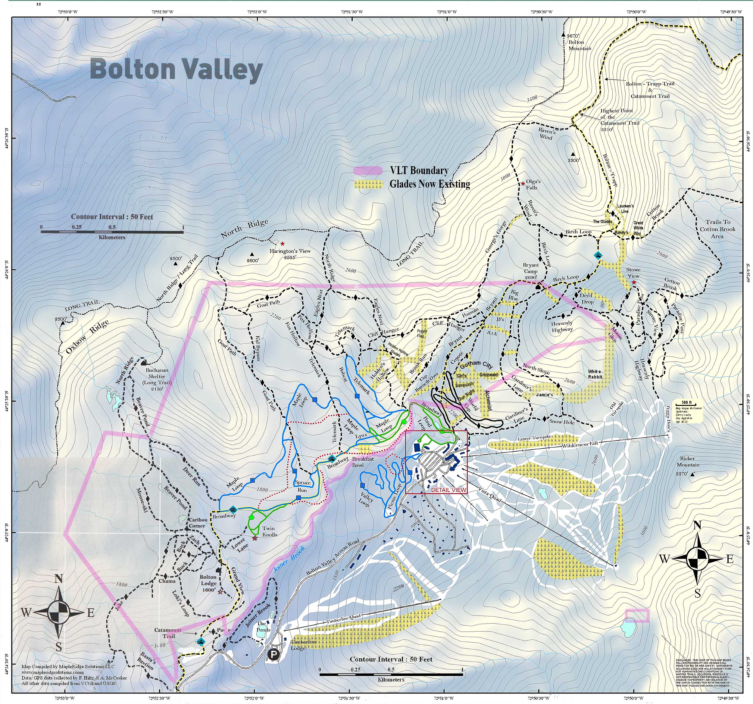
-
You’ve probably already seen it on the Bolton Valley website if you’ve been there, but with the parking, glade maintenance, patrol services, connection to the Nordic trails, etc., Bolton does require skiers on their backcountry network to have a Nordic/Backcountry/Uphill pass. The website indicates that those passes are $17 midweek/$25 weekend, and since they haven’t updated their pricing page since last season, it appears that their prices are the same this season: https://www.boltonvalley.com/winter/tickets-passes/nordic-backcountry-uphill-passes/ If it’s your first time exploring the area, a solid introduction to the network is to park in one of the lower parking lots down by the Nordic/Sports Center (most people want to park higher up closer to the lift access, so these areas are used less) and jump on the Broadway Trail. From there, connect to the Bryant Trail and head up toward Bryant Cabin. The Bryant Trail is also the Catamount Trail during that stretch, so it’s very well maintained, it’s wide, well packed, and has a nice pitch for very comfortable skinning. I’d say the Bryant/Catamount trail is the backbone for the area. Simply looping around Bryant Cabin onto Gardiner’s Lane/North Slope will give quick access to all the glades that descend from there (see the map I attached), and it makes for very convenient laps. The map I attached shows some of the most popular marked glades in yellow. There are of course many more glades that aren’t marked on the map, and beyond that you can simply explore and ski wherever you want and have fun turns where the forest is naturally open enough on its own. For more reference on the area, I’ve got dozens and dozens of trip reports with Google Earth maps on the backcountry page of our website: http://jandeproductions.com/backcountry/
-
With the strong snowpack in the area now, I decided to head out to the Nebraska Valley for some ski touring today. The last time I toured in the Nebraska Valley I was on the valley’s north side, but I’ve now heard from multiple students of mine that the south side of the valley offers some great skiing off the Catamount Trail. I didn’t have too much information beyond the fact that you can just use the Catamount Trail as a collector trail for the terrain in the area, but it sounded pretty straightforward, fun, and convenient. I was able to park right at the Catamount Trail parking area on the south side of Nebraska Valley Road, so the trail access was very easy. It had started snowing around midday, and there was steady snowfall through much of my tour in the afternoon. Following the Catamount Trail southward, the options for great backcountry skiing are indeed very obvious. From the trailhead at an elevation of ~1,000’, the trail rises at a moderate grade for about 400 feet of vertical over the course of perhaps ¾ of a mile, and then the terrain flattens out into a relatively broad valley with the main drainage on your left, and steep slopes rising up to your right. The slopes consist of very open hardwood forest throughout, with tree spacing in many areas as much as 20 or 30 feet. I couldn’t see all the way to the top of the terrain, but there must be hundreds of acres there with very obvious ski lines, and the fact that there were tracks coming down out of this terrain suggested that it held good potential. At around a mile from the trailhead I came to the first obvious skin track that headed up off the Catamount Trail into these slopes, so using that was a clear option for some great runs. I just happened to run into one of my students descending on the Catamount Trail as he and his group were finishing up their session for the day, and he said that if I had the time, I should head higher up because the snow was better. Being my first time in the area, I did want to take a long enough tour to get the lay of the land, so I continued another mile or so and toured up to around 2,400’. The snow was indeed even better higher up, but the tree lines weren’t as open as the beautiful looking terrain I’d seen lower down. The terrain higher up was plenty steep, and certainly offered decent skiing, but I’d say those initial slopes rising from the valley at around 1,500’ are the best bang for your buck as long as the snowpack and snow quality are good at those elevations. It was snowing quite hard up at 2,400’ when I began my descent, hard enough that I would have been worried about being out there in such weather if I didn’t know the forecast wasn’t calling for sustained accumulations. The snow had added another couple of inches to top off the snowpack, which certainly helped make the powder even a bit fresher. Temperatures had been cold much of the afternoon, but on my descent I quickly realized that the freezing level had risen. I descended out of the heavy snowfall down into mixed precipitation by ~1,500’, and just sprinklings of rain down at the trailhead elevations of ~1,000’. I was glad that I’d finished my tour by that point because the lower elevation snow was definitely getting sticky and more difficult to ski.
-
Excellent - so great to hear that you got out to BV for some exploration. Hopefully conditions stayed OK - I was ski touring in the Nebraska Valley today, and later in the afternoon the freezing levels came up. We were snow all the way down into the valleys, through about midafternoon, but they seemed to rise up to at least 1,000' -1,500' later.