

Go Kart Mozart
-
Posts
2,334 -
Joined
-
Last visited
Content Type
Profiles
Blogs
Forums
American Weather
Media Demo
Store
Gallery
Posts posted by Go Kart Mozart
-
-
58 minutes ago, CoastalWx said:
Personally I think Atlantic blocking is overrated. Yes, I know it helps with biggies...but just my overall take.
The KU book says the ideal location for blocking is on the eastern shore of Greenland. This Canadian archipelago stuff just seems to be self-interfering.
-
 1
1
-
-
Not one mention of the euro 961 over MVY?
-
6 minutes ago, Hoth said:
plangent
Word of the day.
-
1
-
 1
1
-
-
55 minutes ago, psv88 said:
Long Island is a barrier island lol, we protect Connecticut. You’re welcome.
The value of our real estate would go way up if we were true ocean front. Please sink into the sea.
-
1
-
8
-
 1
1
-
-
Bills game on Sunday could be interesting. Lake band will be close.
-
1
-
-
35 minutes ago, Damage In Tolland said:
Kind of a Boxing Day look. EMATT not happy
Still two massive storms east of the Mississippi to get through first. Who knows where storm 3 is going.
-
1
-
-
1 minute ago, 40/70 Benchmark said:
GEM blows, too.
At least euro has three rainers
-
1
-
 1
1
-
-
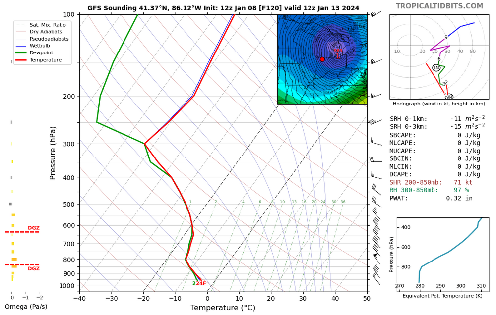
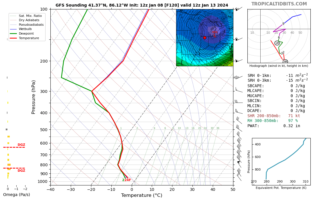
This sounding from South Bend, as the low moves past, is pretty crazy. 16c temperature delta, no shear to speak of until you reach 450mb, no inversion layer, and saturation from the ground to the moon. The lake effect should be massive.
-
 1
1
-
-
39 minutes ago, Ginx snewx said:
Debbie's take a seat
Wow, its gonna be cold in Poland!
-
1
-
1
-
-
Euro gone wild in clown range.
-
13 minutes ago, 40/70 Benchmark said:
I expected January to be underwhelming near the coast...like 1987 and 2003.
It looks like the Rust Belt will end a long snow drought in a big way over the next two weeks. Midwest first....northeast next is not an unusual progression.
-
2
-
-
1 hour ago, UnitedWx said:
I think you kind of see your point if you look at the CMC or ICON regarding the 13th/14th. NOT that I'm telling anyone I take them seriously... but they are called guidance for a reason
It would be nice if the big low near the western Azores can retro a bit, and join forces with the 50/50.
-
1
-
-
15 minutes ago, EastonSN+ said:
I was actually happy getting to 2.5 inches. To be honest I thought I was going to bust with only a half inch.
Yeah, and it weighs a friggin ton. Any idea how much water we received?
-
1
-
-
-
I fully approve, and call it a night:

-
21 minutes ago, CoastalWx said:
Nam was nice.
Was that a Messenger tick?
-
36 minutes ago, WeatherX said:
Agreed. I’ll get like 2” and then drive 3 miles north and see 6” like you said. It’s how we roll down here!
.Ya, I was thinking about October 2011. I was driving home along 95, all rain. Turned up the 8/25, snow began mixing in at Boston Ave. Then a wall of snow at the Bridgeport-Trumbull line.
-
1
-
-
1 hour ago, Typhoon Tip said:
That legend means nothing … it’s just a bunch of colors
Red means run son, the numbers add up to nothing.
-
6 minutes ago, ORH_wxman said:
Reggie shows us how to link the WAA and CCB stuff. Results in a widespread major storm. That’s kind of the optimal look.
That separation deal reminds me somewhat of a scaled-down December 2003, where we had a warm thump, 12 hour break, then a cold blizzard.
-
9 minutes ago, Ginx snewx said:
Trough of warm air aloft
Well yes, I know what the acronym stands for. I was wondering about the physical differences.
-
13 minutes ago, Henry's Weather said:
Preface: not a met, subject to error.
WAA= warm air advection. This mode of precipitation is caused by warm front mechanics, generally. Warm air moving northward. Pre-mature cyclone.
CCB: cold conveyor belt. This type of snow is a result of cyclonic curvature funneling moist air into the dendrite-forming column in the atmosphere on the cold side of a system. It occurs during the strengthening of a cyclone to near peak strength and continues once it reaches maturity.
subject to correction
What's the difference between a CCB and a TROWAL?
-
1 hour ago, Sey-Mour Snow said:
I think we need a sacrifice .. Let's all vote on sacrificing one member off the board for the 00z euro to verify I think we can make that it happen.
Is anyone here a virgin?
-
5
-
-
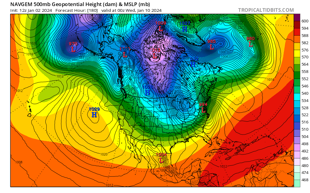
NavGeorge starting to emphasize a coastal transfer:

-
2
-
1
-
-
2 hours ago, Sey-Mour Snow said:
70mb pressure gradient on the storm on the tenth over about 600-700 miles yikes
If the low-level cold is erased, it could be a fun day for a drive the the beach. But still eons into the future.
Monitoring some form of significant ( to be determined more precisely) impact winter storm, Jan 16/17th. Moderate seems to be the upper limit - for now
in New England
Posted
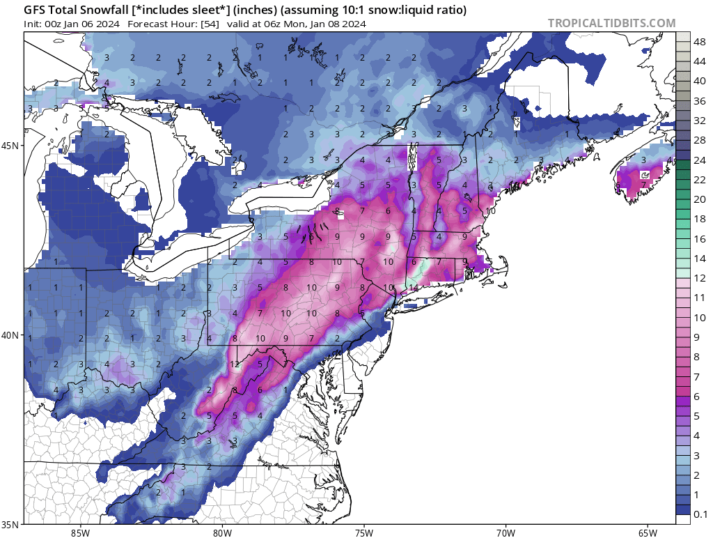
It's funny, but GFS prints out 8" for me. When I was a kid in the 60s and 70s, a forecast of 4"-8" was a BIG deal in SWCT, and double digit storms were rare as dodo birds. Now a forecast of 8" is greeted with yawns.
I guess this is the flip side of the CC burger.