

Go Kart Mozart
-
Posts
2,334 -
Joined
-
Last visited
Content Type
Profiles
Blogs
Forums
American Weather
Media Demo
Store
Gallery
Posts posted by Go Kart Mozart
-
-
I have to wonder about the boundary layer temperatures forecasted by the models. If it is pounding precip, -6c at 850, with steep lapse rates, NNE surface wind, I don't see how it is not solidly below 32f .
Then again, the models process all of this better than I do....so we'll see.
-
3 minutes ago, MJO812 said:
Eps follows the op
Look how far south the lows are now. What a change.


She's got one foot out the door....
-
20 minutes ago, DavisStraight said:
Reggie loves Connecticut

And I love Reggie.
-
 1
1
-
-
This may have been asked, but are we looking at Tsnow?
-
30 minutes ago, weatherwiz said:
the 3km seems nothing like the 12z. I've seen the two differ before but WTF
The Ferrier rime correction is not favorable. Then again, I have no effing idea what that is.
-
1
-
-
2 minutes ago, MJO812 said:

Us southerners like that look.
-
Just checking in for the first time since this morning. I am sure this has been much discussed, but when do we ever see the mesos colder and further to the right than the globals?
Reggie, Reggie, Reggie!
-
33 minutes ago, qg_omega said:
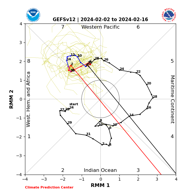
Epic pattern past the 20th is gone but it never was. Need to stop looking at 300 hour plus ensembles. Weeklies need to not be run. I never bought into the PNA, it just never made any sense given the pattern we have been in with the strong PAC extensions, Nino, Maritime forcing etc. SSW and PV splits also have driven the cold each time on the other side of the pole, they need to be examined in the context of the pattern and forcing
Actually a good post! Not just a shot of an unfavorable map, but some solid reasoning. Keep doing that, please.
-
 2
2
-
-
46 minutes ago, 40/70 Benchmark said:
My crack is already emitting radiance upon exiting the autimobile...
Yeah, I felt prison naped by the sun today.
-
2
-
-
1 hour ago, MJO812 said:
Gefs

.thumb.png.d11f1f37918bd5bf7b6438092186ab6b.png)
.thumb.png.8f4b3774b889dc8b1d3c5d63d7335fff.png)
The thing about those clusters....there aren't any. Still birdshot.
-
2
-
-
1 hour ago, Typhoon Tip said:
First of all, every thread I've started in the past 3 years has been > 75% correct at long leads, and some were remarkable at ranges of 7 to even 10 days.
Some of you are bit too brash/rude and don't paint a very good picture of yourselves... Plebeian witted
Yes, you're great. We (the great unwashed masses) suck.
-
4
-
-
4 minutes ago, 40/70 Benchmark said:
I don't like the look of that....lots of members inland. The mean is pulled south by the seaward outliers. Looks good for Powderfreak.
The spread actually seems greater in terms of longitude rather than latitude. The question might be how fast, early capture, etc.
-
1
-
-
2 hours ago, weathafella said:
Don’t eat yellow snow!
OK Frank.
-
19 minutes ago, 40/70 Benchmark said:
On a global scale....
Yes, but does the global scale affect particular storm totals in NS? Or we need to look specifically at that storm's ingest regions.
-
40 minutes ago, tamarack said:
More atmospheric water helped, but like Feb 1969 the real key is how long it snowed - 5 days in NS?
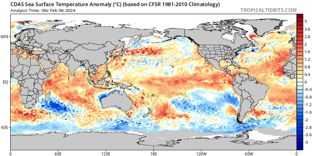
The thing is, I'm not so sure the waters to the east of NS are that warm. Admittedly this is yesterday's depiction, so maybe they were warmer when the storm began...I don't know.
-
1 hour ago, weathafella said:
I think I read maybe 15 years ago that robins retreat into the woods for winter but don’t fly anywhere. Growing up I thought they migrated.
"They follow the 37f isotherm", that's why they seemed to never leave.
-
1
-
-
15 minutes ago, butterfish55 said:
My Aunt's house in Inverness, right by the beach. Feet of snow

Cape Breton one of my favorite places on the planet (earth). Paging Hazey...how did you do?
-
3
-
-
4 minutes ago, STILL N OF PIKE said:
Edibles, Bourbon or shrooms
Maker's Mark for me tonight!
-
4
-
-
After dicking around in 7, the MJO goes off-the-chart 3 in less than a day....
-
4
-
-
20 minutes ago, CoastalWx said:
Does that mean it will snow?
Not in Plymouth.
-
Imagine if you were a weenie living in Moncton? GFS 36", euro a few flurries.
-
9 minutes ago, Prismshine Productions said:
Bruh the GFS


Sent from my SM-S146VL using Tapatalk
CT River Valley and Cape Cod the jack zones? You don't see that pairing every day.
-
6 minutes ago, Sey-Mour Snow said:
Just posting so others can follow along with the friendly wager.
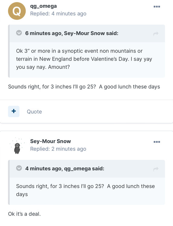
Just askin...but would say.... Litchfield CT be considered non-mountainous?
-
1 hour ago, qg_omega said:
Done, PM me
How will you guys define a threat? You'll need a referee.

.png.c6b1121593acd9347fd6572b619e91da.png)
.png.88a4a4923e63f144e0ed0e5b96c5c914.png)

Following a Miller A/B hybrid type coastal potential, Feb 13th ... As yet untapped potential and a higher ceiling with this one
in New England
Posted
Uh oh, he's going third-person on us.