
TWCCraig
-
Posts
2,462 -
Joined
-
Last visited
Content Type
Profiles
Blogs
Forums
American Weather
Media Demo
Store
Gallery
Posts posted by TWCCraig
-
-
0.0" again
0.30" for August
0.78" since July 1st
-
3 minutes ago, IrishRob17 said:
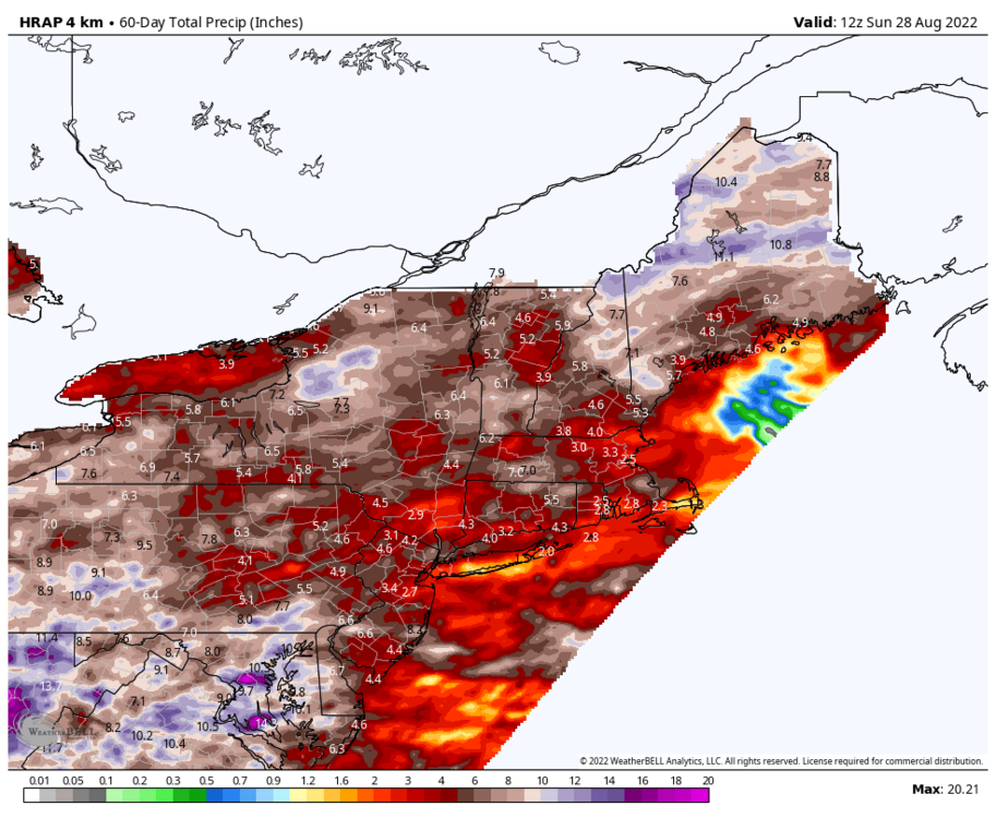
I'm about two miles south of that 2.9 at KMGJ, it looks a tad high, only 2.09" here over the past 60 days.
It's a bit high here too since FRG has only had 1.00" since July 1st. It'll blend the precip totals over a space since it doesn't have the resolution to pinpoint exactly where it has and hasn't rained. Though it is good to show where some areas have done better, and worse.
-
 1
1
-
-
Rough estimate of precipitation totals over the past 60 days. Shows the south shore of Long Island being the driest in the entire region, on par with a portion of the Cape.
-
1
-
-
7 minutes ago, SACRUS said:
Always forget to bookmark that site, but id be curiou s of 80 degree days and where we stand at the major locations and stations.
What site is that with the time-series summaries? The one @bluewave posts. I would love to find out the driest 60-day/90-day period for each of climate sites around here.
-
1
-
-
Looks like ISP will get hit with a storm, bringing their monthly total up. Storm just missed to my north. Bone dry here
-
1
-
-
6 minutes ago, jm1220 said:
Radar says maybe 0.50” there. It was tiny and flew by. Enough to make some puddles and that’s it, wayyy more needed.
That cell weakened a lot by the time it got here. Just a sprinkle here with the sun trying to come out already. It just doesn't want to rain
-
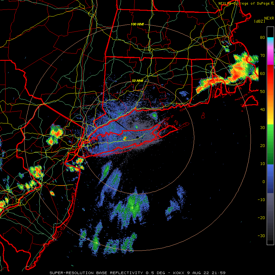
That cell over Long Beach looks decent. If only it would just hold together by the time it gets here.
-
-
24 minutes ago, Rjay said:
And a bit over an inch came with that supercell in July if I recall correctly.
This is the driest July 1st - August 25th period on record at ISP. 1966 had 2.91" by this day. FRG has only had 1.00" since July 1st.
-
1
-
-
10 minutes ago, Rjay said:
No relief in sight. I'm sure the usual areas will see some storms at some point over the next 2 weeks though.
Can only hope the HRRR is on to something for tomorrow. Would certainly help bring some temporary relief
-
1 minute ago, WestBabylonWeather said:
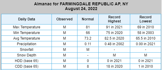
I think farmingdale record high was 88 which was tied today.
I have the MSN weather client on my desktop and it alerted me to that
Oh ok, they must have not updated that site because it hit 91 on this day last year at FRG. But then again, FRG's period of record only starts in 1999
-
1
-
-
40 minutes ago, WestBabylonWeather said:
Looks like we tied the record high of 88 on Long Island today. I’m a little shocked that was the record and not higher.
What site? ISP's record for today is 91 set in 1995
-
1 hour ago, LongBeachSurfFreak said:
Part of me is pretty sad that the drought will intensify on the south shore of Nassau, with many trees already dead or dying. On the the other hand I find any extreme weather event interesting.
.00” for yesterday in wantagh at my parents and .00” at my place in Lynbook
.The drought to me is pretty interesting. Almost a Mediterranean style summer. Only had 3 events since the beginning of July over 0.10" of precip. A nearby station recorded only 0.78" since July 1st. Consistent stable marine air on the south shore pretty much kills any chance, but it's usually not this bad. Globals are continuing the dry spell here. Must be a lot of sinking air on the western flank of the WAR.
-
23 minutes ago, WestBabylonWeather said:
Sunny in western Suffolk. Was looking forward to some rain too.
0.00" here, not too far from you
Maybe we can get some showers tonight or tomorrow. Not getting my hopes up though.
-
 1
1
-
-
Bust
-
Models look pretty good for rain chances tomorrow. An area wide 0.5-1.0" is possible, however, convective precip can favor some areas more than other areas. Most models have at least 0.25" for the entire region. It's entirely possible some areas see a good amount of rain while some areas stay with lower amounts. Some areas could see a couple inches. Either way, the chances of rain are very high for tomorrow.
-
2
-
-
0.0" here, so far, might get a little rain in a bit.
Easthampton picked up 0.74" of rain today and dropped to 59 degrees during the heaviest rain.
-
Huge difference in humidity levels across the area
From Mesowest:
NYC: 88/50 27%RH
EWR: 90/54 30% RH
LGA: 90/50 26% RH
ISP: 82/70 66% RH
-
2
-
-
Some light rain this morning. Nothing to write home about but still plenty of time before we figure out what happens with the next system. Euro and GGEM were east with the heaviest rains, with the Canadian being very far east. GFS is the furthest west. We will see the models go back and fourth until we get a better picture downstream.
-
6 minutes ago, psv88 said:
Just a moderate rain shower...not sure the NAMs 2 inches is going to verify...
Don't have a working gauge but I'd estimate between 0.1-0.2", matches up with the radar. Gladly take over basically nothing the past several weeks.
To speak of the greatness of the NAM, it doesn't have anyone in this forum hitting 80 degrees tomorrow lol
-
4 minutes ago, psv88 said:
Its fast moving anyway. Even if it hits, maybe you get 0.20
I'm just glad it's going to rain. I'll take anything. Going to pour any second now
-
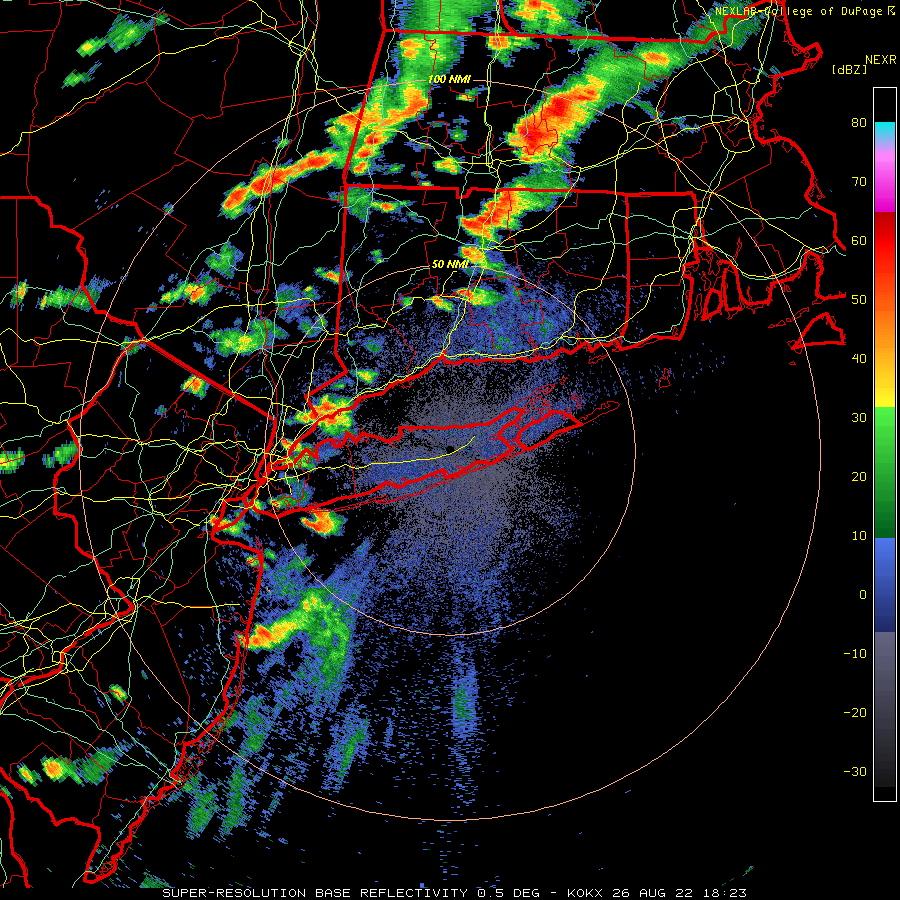
Decent small cell over north central Suffolk, fired up along the frontal boundary. Cell in NW NJ is heading towards the city

-
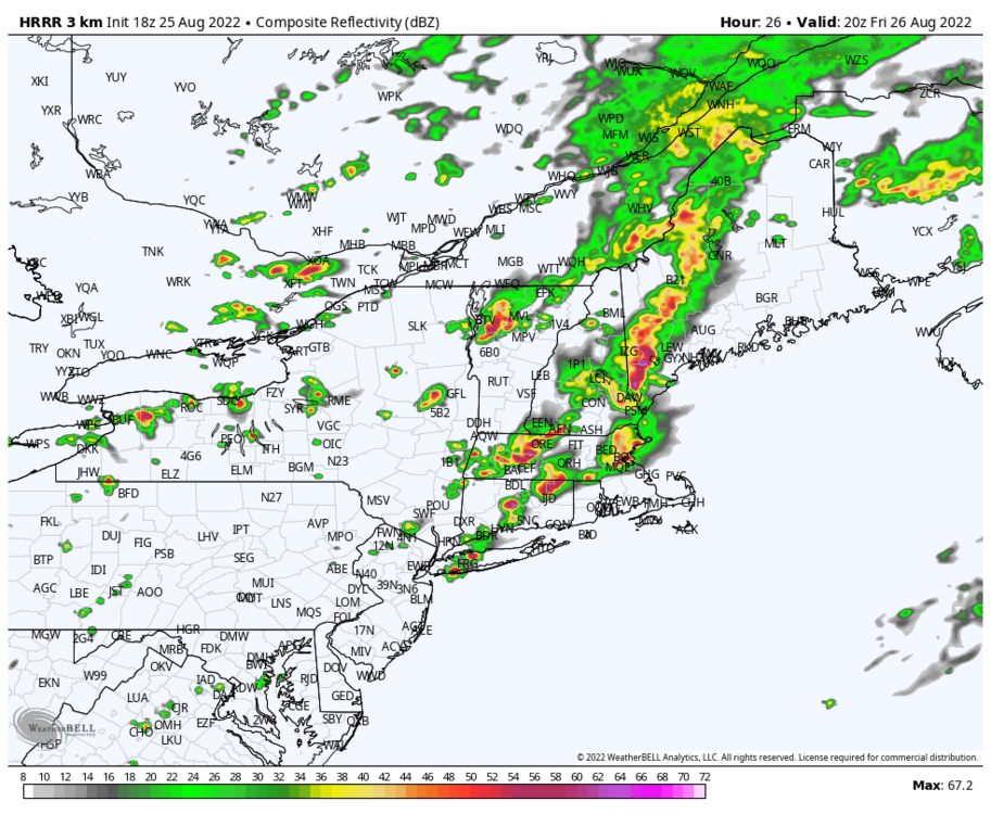
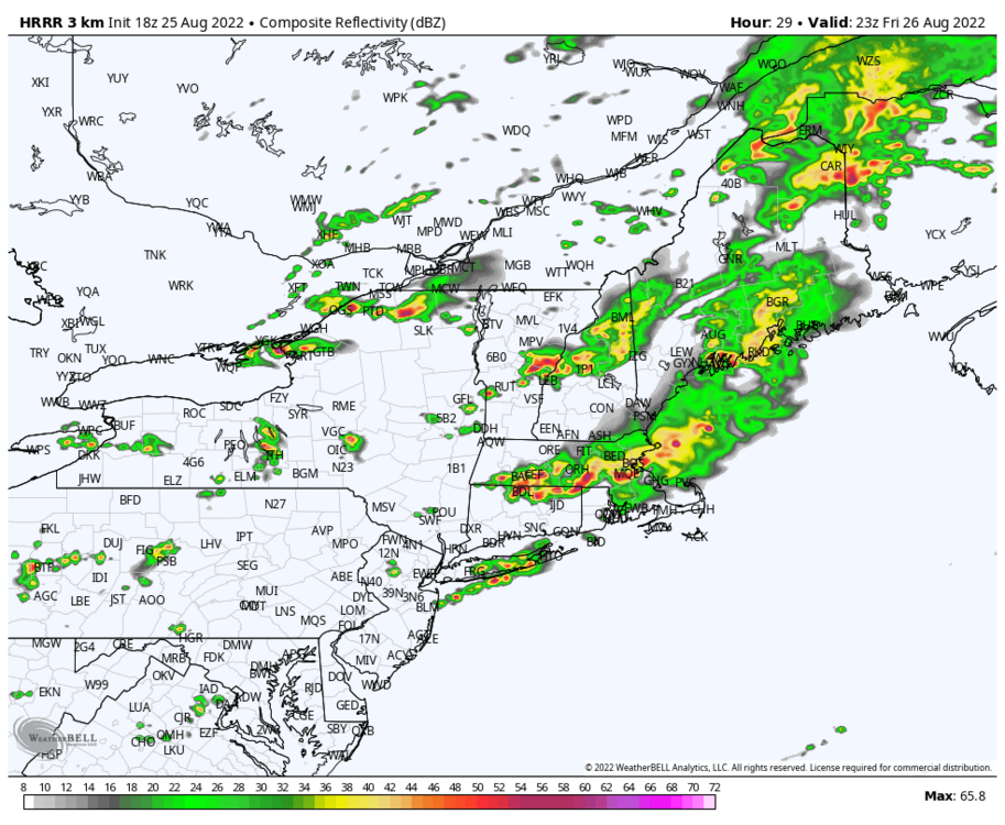
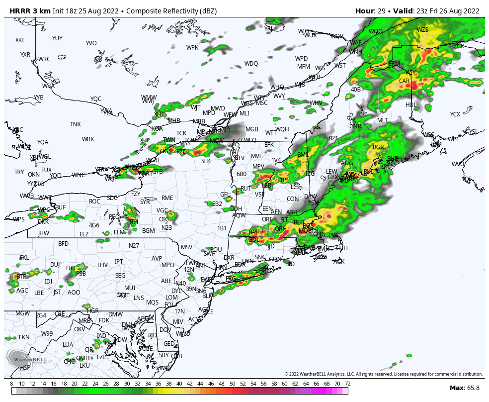
HRRR has consistently, since 0z run last night and almost every consecutive run, been showing cells firing over central Long Island during the evening hours tonight. It hasn't been too bad with the location of cells for today, it had the storms over the sound, north shore, CT and SE New England, so who knows if it will be right. Obviously, no model is perfect with convection like this. The front is pretty visible on OKX, still over CT. Storms are still building off of it. Interested to see what happens when it hits the sea breeze boundary.
-
Cool down for this upcoming weekend and then slowly fading back into an above normal pattern. Euro weeklies continue the above normal pattern into September through the end of its run
-
1
-


August 2022
in New York City Metro
Posted
If it wasn't for the 1st of August being below 80 degrees, ISP would currently have it's longest run of consecutive 80+ degree days at 63 days. August 2022 was the warmest August on record at ISP as well.
for Islip Area, NY (ThreadEx)
Click column heading to sort ascending, click again to sort descending.