
TWCCraig
-
Posts
2,461 -
Joined
-
Last visited
Content Type
Profiles
Blogs
Forums
American Weather
Media Demo
Store
Gallery
Posts posted by TWCCraig
-
-
ISP already broke their record at 65
64 here and starting to fall slowly. Sea breeze might be kicking in now
-
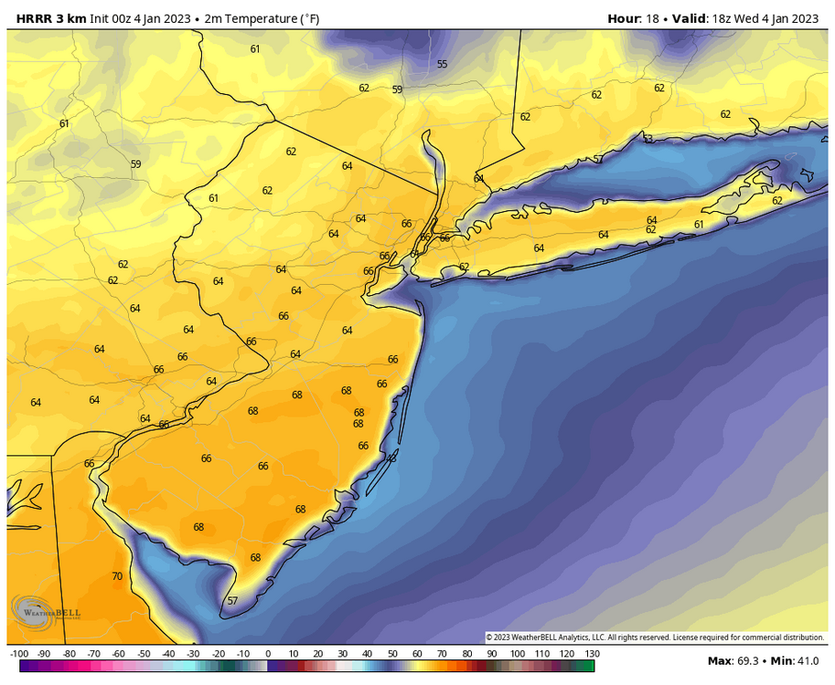
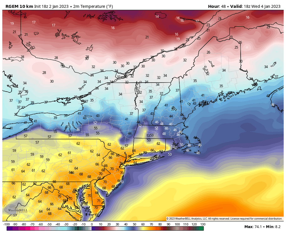
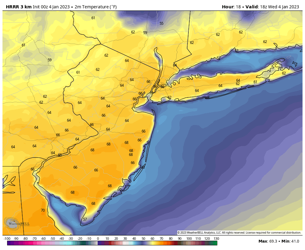
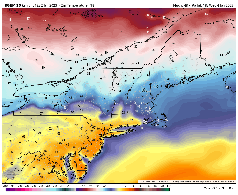
Temperatures could end up higher if there's less clouds tomorrow. HRRR would tie the record at NYC at 66 (1950). RGEM has 68 in the city. Newark and places S&W of the city could see 70s. NWS has 58 for me, I think we reach 60 here at least
-
 1
1
-
-
RGEM and the higher resolution HRDPS both have 70's for Wednesday
-
2
-
 1
1
-
-
1 hour ago, the_other_guy said:
The temperature variances in the city during these warm ups astound me over the last 10 years?
why can’t the city cool off at night during these warm periods? Why is the UHI stronger than it is during any other period? It makes no sense.
Central Park at 48F. Every suburb is 10-15 degrees cooler at 8 am!
No CAA. Strong winds like we had with the past cold snap help to even the surface temps out more. With strong winds, temps are more uniform. On days like today with no CAA, rural and suburban sites see radiational cooling, which doesn't happen in the city because of UHI.
Quotebut it seems to only happen in these extreme variances when we are transitioning from a cold air mass to a warmer air mass.
I just don’t understand why that is and I wonder if there was a study on that
With an incoming warm air mass, the warm air is basically "overrunning" the cold air since warm air is less dense, meaning you have warming aloft but a lot of low level cold air still in place which can take longer to mix out. This time of year we can get some crazy inversions with warm air aloft and colder temps at the surface.
Not the correct thread, but some places will see 60 today!
-
With how close some observation sites came to reaching 50 degrees today, I think it's pretty likely that tomorrow will reach and/or exceed 50 degrees.
-
7 minutes ago, the_other_guy said:
I mean, if it was November, it would’ve been erased.
When was last time we have had a well BN (or normal) second half of Dec?
2017
Though that was more/less a below average month in general with a few warmups here and there. Last week of Dec was very cold, over a week of sub-freezing highs
-
1
-
-
A sad day for what is a great website for GOES satellite data. Doesn't affect our area but it was cool being able to see the entire western hemisphere (both north & south). Bandwidth issues... any other great satellite websites out there?

-
Flakes flying in West Islip
-
1
-
-
28.8 or 29 if you round, was the low here before clouds moved in
-
34 already, should freeze easily tonight. Will be the first freeze of the season
-
2
-
-
17 minutes ago, lee59 said:
I understand southern Nassau may be a little more urban than southern Suffolk but not really that much especially western Suffolk. So I don't know why southern Suffolk is different especially far eastern Suffolk like Montauk area.
The only places on Long Island that have dropped below freezing so far, thus ending the growing season, are the pine barrens out east. Freeze warnings/watches, in my opinion, should be issued until we actually drop below 32. Not sure about Upton's reasoning since ISP and much of the island hasn't had a freeze yet. They have the city in a freeze watch, but it will likely stay above freezing in the city. With enough radiational cooling and calm winds, most of the island could see a freeze Monday night/Tuesday morning. Personally, I would have the whole island under a freeze watch, and exclude the city.
-
Another 70+ day in November. Crazy
Winds are stronger now than they were last night
-
NYC has yet to drop below 40 degrees so far this season. We will likely drop below 40 degrees on Monday (11/14), making this the second latest sub-40 degree reading on record
SeasonFirstValueMissingLastValueMissingDifference1938-1939 11-15 (1938) 37 0 04-18 (1939) 39 0 153 1946-1947 11-13 (1946) 38 0 05-10 (1947) 36 0 177 1977-1978 11-12 (1977) 37 0 05-01 (1978) 38 0 169 1916-1917 11-12 (1916) 38 0 05-04 (1917) 38 0 172 1994-1995 11-11 (1994) 38 0 04-10 (1995) 34 0 149 1898-1899 11-11 (1898) 38 0 04-17 (1899) 39 0 156 1961-1962 11-09 (1961) 35 0 04-17 (1962) 34 0 158 1943-1944 11-09 (1943) 38 0 04-15 (1944) 37 0 157 2019-2020 11-08 (2019) 29 0 05-10 (2020) 39 0 183 2017-2018 11-08 (2017) 39 0 04-21 (2018) 39 0 163 1955-1956 11-08 (1955) 38 0 05-17 (1956) 39 0 190 1971-1972 11-07 (1971) 34 0 04-26 (1972) 38 0 170 -
1
-
1
-
-
Dewpoints are in the 20's in the city with temps in the low 70's. Crazy from the 60 degree dewpoints we just had
-
1
-
-
This is the warmest November day on record for most of us. Roasting at 79 here. Hope to see ISP hit 80
-
1
-
-
78 at ISP ties all time record
-
Already 70, ISP may hit their all-time high today if it gets warm enough. 78 is the record. HRDPS has 79, HRRR 77
-
1
-
1
-
-
It depends on the activity, and everyone is different with what they can handle and what they prefer. I prefer the warmer weather for outdoor activities in general, but the physically demanding activities are better when it's cooler out. There have been times I've been out shoveling snow in 30 degree weather with 25mph winds in a t-shirt and still be comfortable. If I wasn't shoveling, I'd probably be cold.
69 with filtered sun here
-
GFS brings temps near 80 degrees on Monday. Some daily maximum records are in play as well as all-time highest minimum temp for November. NYC's all-time highest minimum temperature for November is 67. The record high for Monday is 78 set in 1938.
-
1
-
 1
1
-
-
35 this morning, coldest of the season so far
-
What a monster Sandy was. 10 years ago today. Probably one of the most powerful storms that most of us experienced. I wasn't in an area that flooded, that alone was crazy enough, but the winds were nothing like I've ever seen. The sustained winds of 40-60+mph were just insane. It's not like a gust of 40-60mph which is strong, it was sustained at those speeds. Seeing the trees bend like never before and lucky that some didn't snap. The gusts were insane, many gusts were 70-90mph. I remember looking at the clouds race across the sky from east to west faster than I've ever seen. I kinda wish I could go back in time just to relive the event.
-
76 right now, maxed at 77
FRG hit 78, 79 on Mesowest
-
1
-
-
70 and Sunny
-
1
-
-
Heavy rain with the sun trying to come out. 63 degrees
Out of our area, but it managed to reach 75 degrees today on Nantucket
-
1
-
January 2023
in New York City Metro
Posted
RGEM and GEM-LAM nailed today's temperatures. They were the only models showing 60+ temps for LI, until the HRRR did as well. They were the only models showing the possibility of 70+ degrees in NJ