
IntenseBlizzard2014
-
Posts
3,188 -
Joined
-
Last visited
Content Type
Profiles
Blogs
Forums
American Weather
Media Demo
Store
Gallery
Posts posted by IntenseBlizzard2014
-
-
44 minutes ago, AfewUniversesBelowNormal said:
It could lead to a multi-year Nino. +AAM is basically the Earth slowing down.
Wow. Fascinating. I can see next winter being a dud. Multi-Year Ninos usually have that one dud.
-
1 minute ago, LibertyBell said:
we really need to have an el nino thread like we had in 2015-16. There are people in the main forum and in the NE forum saying it's still weak and going to stay that way
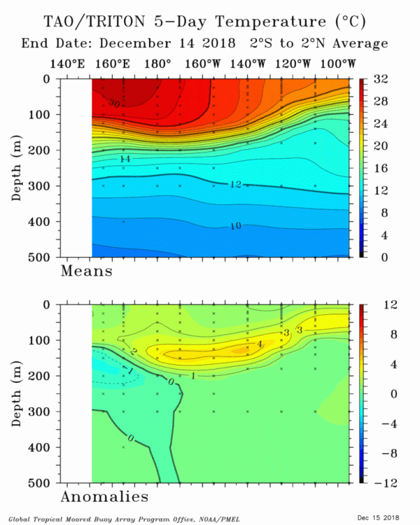
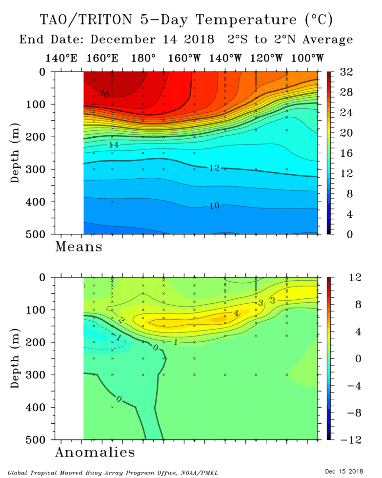
In the next several weeks, this is definitely not going to be weak. More like low-end moderate. Very impressive positive anomalies at a depth of 150m at 140*W to 180*W.
-
 2
2
-
-
1 minute ago, LibertyBell said:
Don is the el nino going to remain weak? Moderate is better for our area but if it remains weak we can safely remove 1997-98 and 2015-16 from that list and also 2006-07 and 2009-10. We would be left with 2004-05 and 2014-15.
It's already at a moderate threshold.
-
12 hours ago, AfewUniversesBelowNormal said:
This is called +AAM, late blooming Nino's.

What effects will this have down the road?
-
26 minutes ago, Brasiluvsnow said:
Agreed but this could be a real problem for those inland
Yeah. Light freezing rain and sleet. With power outages.
-
3 minutes ago, Brasiluvsnow said:
I have to chime in and agree that I am very surprised that there is not more talk anywhere about tomorrows storm,,,,its going to be interesting especially N n W
Nothing but light rain for the coast.
-
1
-
-
3 minutes ago, Dan76 said:
Will NOV be are biggest storm ?
Probably not. We just need the SOI to cooperate. Then we are good to go.
-
27 minutes ago, bluewave said:
This is the first time that we have El Niño threashold SST’s combined with such a positive SOI in December. I have been pointing out the lack of coupling between the ocean and atmosphere going back into the mid to late fall. Now the forcing is moving to the La Niña-like MJO Martitime Continent phases. You can see the longer range guidance moving to more a -PNA look later in the month. My guess is that this is related to all the record SST warmth north and east of Australia.
SOI
15 Dec 2018 1012.11 1005.25 16.29 4.29 0.82 14 Dec 2018 1013.05 1005.15 21.69 3.69 0.72 13 Dec 2018 1012.83 1005.20 20.29 2.95 0.59 12 Dec 2018 1011.75 1005.45 13.39 2.36 0.46 11 Dec 2018 1010.69 1006.20 4.00 1.89 0.37 


That +SOI is tipping the scales a bit. Although the El Niño is already in Moderate territory. So eventually the +SOI will be overwhelmed.
-
The 12Z GFS suggests that we should keep an eye on Christmas.
-
1 hour ago, raindancewx said:
Don't shoot the messenger but the JAMSTEC has completely flipped and joined the CFS with the super hot US winter. I may ask one of the Jamstec scientists on Twitter why their model is so volatile, they seem pretty nice and tend to respond to questions. The Northern Plains did show up as warm in nearly every independent method I could come up with, not just ENSO, so I think that makes sense, and really, that is the one area, along with NM/TX that didn't flip from last month.

I think I'm actually pretty on board with the precip map below, this pattern doesn't seem particularly wet nationally unless the SOI starts to crash to juice up the subtropical jet. The +20 reading for yesterday isn't going to help with that.

The other images are not working for me on their site right now, if someone else wants to give it a go. http://www.jamstec.go.jp/frcgc/research/d1/iod/e/seasonal/outlook.html
The December run last year actually did fairly well, I'd give it a C+. Was definitely better than the Nov 2017 run for what its worth.

The precip map was actually quite excellent, one of the best I've seen from a seasonal model - solid A for me.

Could be confusing that with the cold and dry/warm and wet pattern.
-
8 minutes ago, CIK62 said:
Well, the highest low temperature for a whole season is 19, in 2001-02, and we have already beaten that. The least seasonal snowfall is about 2", and we have already beaten that too. Some member mentioned that the NAM kept moving the heavy rain to the south. Now just imagine this was mid-winter. The system is in the meso-scale time frame and still can not finalize its output.
BTW: The EURO WEEKLIES, just out today, show no weekly cold till Jan. 18. It does not look impressive even then, as North America appears to be burning up for the whole 6 weeks, except the last two along the EC.
Oh. I see. Supression. Also, the Euro Weeklies may continue to be erratic until the elongated PV is nearly finished stretching from Eurasia to Canada.
-
1
-
-
2 hours ago, CIK62 said:
I think we have every reason to believe that the 15F Low T and 6.4" of Snow in November, will hold for the rest of December----but not for the winter season.
They could actually hold up and not set any records however for the season, and that is worrisome.
With the state of the models and expectation of a lot of snow action eventually, a bigger goof than the November one is of high probability. Like this weekend's rain which could be a 20" mid-winter's storm on one run, then 2", and no Blixxard Warning needed, on another.
Hmmmm.....elaborate, please?
-
2 hours ago, SnowGoose69 said:
It’s strange how in the last 8 years we’ve seen winters behave in the reverse ENSO state they’re in. 2010-11 seemed more like an El Niño outside of the back end shutting off. December 2015 behaved more like a La Niña with a SE ridge vs just a blowtorch zonal pattern and now this month is showing some La Niña signals.
Although this is good. When the transition happens, both streams will be fairly active and provide the coastal storm activity that we desire.
-
43 minutes ago, IrishRob17 said:
Millennials have no idea the struggle this hobby was before the internet and all of this easy access to pretty much everything

Millennials were born as early as 1982.
-
1
-
-
1 hour ago, mikem81 said:
Looks like a typical dry and cold and then wet and warm followed by dry and cold pattern...
Until the 23rd.
-
1
-
-
2 hours ago, CIK62 said:
Next 8 days averaging 37degs., or about 1deg. BN.
Just a 35% chance of at least 2" of Snow during the next 15 days----GEFS. EPS has had empty 10-day periods for 3 days now.
Something should pop up by the 24th or so. The transition to more El Niño weather will create some interesting weather for the East Coast.
-
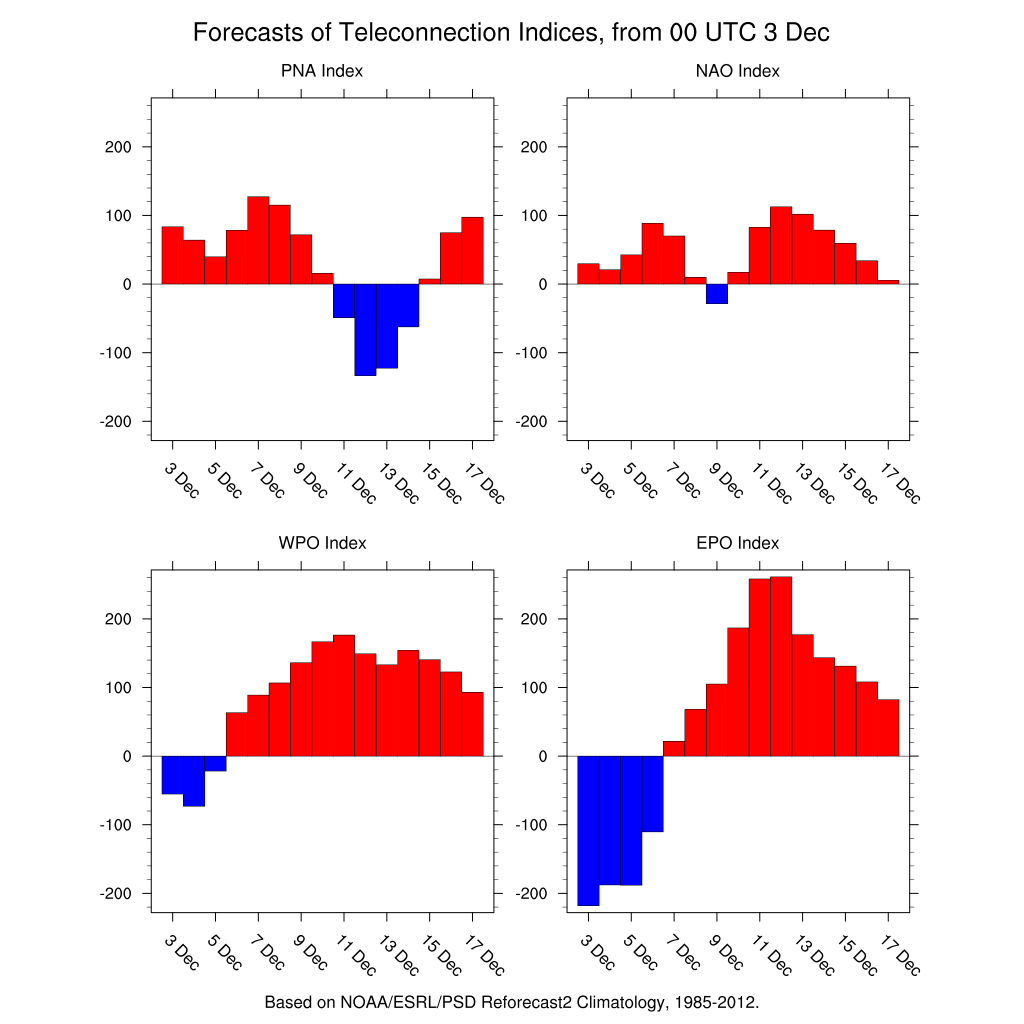
The upcoming storm will provide snow for those that live between South Carolina and Pennslyvania. Although after that's over, a slow thaw and then DC to NYC needs to gear up for the possible snowstorm by Christmas Eve. The teleconnections show promise, based on extrapolation.

-
3 hours ago, raindancewx said:
Is there anything that could convince you that December could be warm other than 100F days every day at this point? It's not me trying to be mean. Three warm days. More are coming. This was supposed to be the cold part of the month for you guys. This is MJO phase one right now, that can be quite cold in the NE in December. Phase 2-3-4 are all warmer. I'd say progression into 2-3 is close to guaranteed at high amplitude at this point for Dec. The NAO is positive, and looks to stay positive for awhile. The month so far looks like the composite for +NAO Decembers over the last 60 years. The first three days of November were honestly pretty close nationally to the final monthly figures for what its worth. The MJO migration, +NAO, Nino 4, cold Nov in the Plains, the subsurface analogs, the SOI, and CPC all favor warmth for at least several weeks of December for most of the US. I don't know what more you could want. I don't just say stuff like this for fun, there are pretty clear signals for warmth all over. Decembers in recent El Ninos like 1991, 1994, 1997, 2002, 2004, 2006, 2014, 2015 all had at the least, very warm spells in the NE in December. Other than 1997 and 2015, all of those years have at least some similarities to this event. The Fall pattern in 1963 was very warm, and then went very cold in Dec. We were opposite 1963 in Fall, and so far, it looks opposite in Dec. So there is that too.


Here is the MJO basis - CPC is fairly well grounded for this. NAO is nice and positive for now, and what looks like a while too....and it looks like this month so far?

Above average, yet hardly. There's some interesting weather coming for the East through the 20th. You'll see. It's the strong MJO burst through Phase 8 that's the culprit.
-
DCA: -1.1
NYC: -0.9
BOS: -0.7
ORD: -0.9
ATL: -1.5
IAH: -0.5
DEN: -0.4
PHX: +0.7
SEA: + 0.6
-
 1
1
-
-
Just now, bluewave said:
Here are the top 5 snowiest Novembers for each station and the seasonal snowfall.
NYC
#1...19.0.....1898.....55.9
#2...14.0.....1882.....44.1
#3...12.8.....1938.....37.1
#4...6.4.......2018.......?
#5...6.3.......1892.....49.4
Chicago
#1...14.8......1940.....52.5
#2...14.5......1895.....53.6
#3...14.3......1951.....66.4
#4...12.0......2018.......?
#5...11.2......2015.....31.2
Thank you. Based on these stats. Both of these cities may experience well above average snowfall.
-
18 minutes ago, bluewave said:
Very rare for NYC and Chicago to both have their 4th snowiest November at the same time. This is one of those events that could only be possible during the snowy 2010's.
Nov 2018 snowfall rankings
NYC....#4....6.4"....... Chicago....#4.....12.0"
What were the records they both broke?
-
2 hours ago, SnoSki14 said:
If that black hole over Alaska becomes a permanent feature, then you could kiss this winter goodbye.
Very bad signs heading forward.
Still has that Nina look to it. Eventually, it will fade once the effects of the El Nino kick in.
-
December 25th, 2018. Seems unusual, yet very possible. The MJO will go for a stronger burst through Phase 7/8/1 through December 20th. Which will make it very favorable for colder and stormier weather a few days later.
-
1 hour ago, raindancewx said:
I've learned a few things about this and it's too late. This will reflect into March 2019. Lag effect.


December 2018 General Discussion & Observations
in New York City Metro
Posted
This Niño didn't peak yet. It's certainly possible.