
IntenseBlizzard2014
-
Posts
3,188 -
Joined
-
Last visited
Content Type
Profiles
Blogs
Forums
American Weather
Media Demo
Store
Gallery
Posts posted by IntenseBlizzard2014
-
-
1 hour ago, bluewave said:
Unusual pattern coming up. The 12z Euro gets the tropical system stuck under the building heat ridge. It crawls for days over the Central US dumping torrential rains. Acts as a heat and humidity pump for us with a deep SW flow.Temperatures in the 90’s with dewpoints in the 70’s will result in very high heat indices. Some hints at beneficial rains for us near the end of the 10 day period with the tropical remnants.


Yeah. I have noticed that we are always finding some sort of way for high dew points. Why is that?
-
5 hours ago, Stormlover74 said:
I won't mind it if we lose the humidity
Yes. I'll take low 90s and low dews any day in the summer.
-
I'm impressed with the lower dews in the daytime. Makes going outside much more bearable.
-
 1
1
-
-
1 hour ago, NYCweatherNOW said:
I disagree I think this summer ends up hot and dry. It’s been wet and cool.
As long as it's not humid, then it's fine.
-
1
-
-
12 hours ago, LibertyBell said:
and if things go according to form, we'll have a raging + NAO come winter.
I'm not sure if that will happen. We'll have to wait and see for a few more months.
-
47 minutes ago, Cfa said:
Is that sun?????????? Omg.
I know right? Finally!
-
On 6/15/2019 at 8:36 AM, TriPol said:
So, not to get into any climate change debates or anything, but there is MASSIVE ice melt from Greenland coming early this year. Would the melting ice have anything to do with the cool waters off of the NE coast and our weather being cooler than normal?
Yup. I suspected this from a couple of months ago. The cold pool of water may actually limit the heat up here, but a strong SE ridge can easily counter that.
-
1
-
-
4 hours ago, bluewave said:
The Greenland block fades in early June just like the SE Ridge. This would fit with the summer pattern since 2015 of July and August having a warmer temperature departure than June.

It's funny. The CANSIPS had this exact setup running through the summer.
-
5 minutes ago, bluewave said:
The SE Ridge would have completely dominated the pattern if it wasn’t for the near record May Greenland block. Instead, we will probably finish May with 3 short warm ups. The Newark 89 on the 20th...first possible 90 tomorrow...Maybe the warmest day of the month on the 30th.

We won't be lucky for long. I've heard through the grapevine that the Greenland Block will start to fall apart through June.
-
9 hours ago, tek1972 said:
But it will also have less of an effect as SST'S warm
Sent from my SM-N960U using Tapatalk
SSTs off the Atlantic need more ridging off the coast. Without that, we would have to rely on the ridging in the Southern US. Which tends to be limited in terms of movement. So this summer, we will probably have very limited heat, but lots of high humidity and thunderstorms.
-
5 hours ago, bluewave said:
The spring is turning into our most reliable season for -NAO patterns.
May 2016...May 2017....March 2018....May 2019...
2016   0.12   1.58   0.73   0.38  -0.77  -0.43  -1.76  -1.65   0.61   0.41  -0.16   0.48
2017   0.48   1.00   0.74   1.73  -1.91   0.05   1.26  -1.10  -0.61   0.19  -0.00   0.88
2018   1.44   1.58  -0.93   1.24   2.12   1.09   1.39   1.97   1.67   0.93  -0.11   0.61
2019   0.59   0.29   1.23

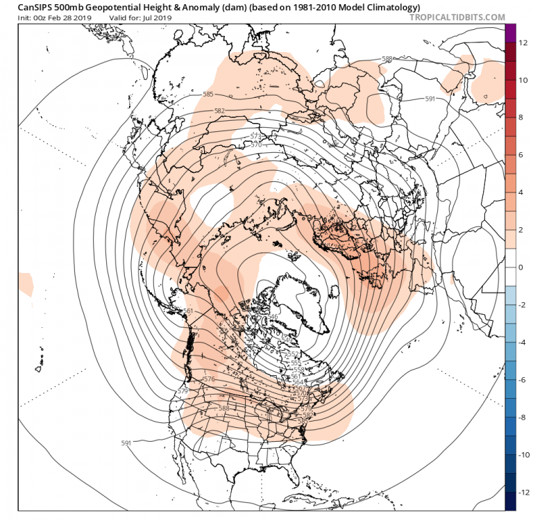
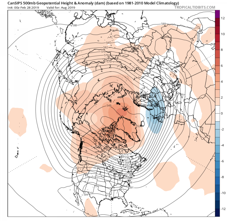
The CANSIPS model is still insisting that we will be under a humid airmass for most of the summer. Although it's not going for heat this time. Looks like the heat will be suppressed at this rate. The hottest part of the summer seems to be in August and September, according to the CANSIPS.
EDIT: Looks to me that the more recent CANSIPS is slightly warmer for most of the US. Looks like an inferno for the SW US this summer, with the Death Ridge poking into the SE US from time to time. This was not the case from last month's CANSIPS run.
-
On 3/7/2019 at 11:27 AM, etudiant said:
Well, if a 1936 + 0.15C rerun is going to happen, summer will be toasty.
Interesting comparison. The most recent CANSIPS is sniffing this out.
July 2019
August 2019
-
36 minutes ago, raindancewx said:
Through 2/22 the February SOI is down to near -16, the threshold our Kangaroo Buddies consider Strong El Nino territory. Another big Kelvin Wave is heading east and "up" just in time for March.

You win.
-
28 minutes ago, CoastalWx said:
Frustrated as all hell. That’s what happened. I am a storm guy. Even those have been weak sauce. At least in a super niño we can lose roofs in all rain events.
I'm collecting tons of computer model data for a possible significant storm (snowstorm?) for the Northern Mid-Atlantic to New England. This might happen by late month. It's taking a lot of time, but I feel that it might pay off.
-
 2
2
-
-
3 hours ago, AfewUniversesBelowNormal said:
A lot of convection over ENSO.

This is actually the strongest El Nino-OLR push of the entire El Nino event.

Second strongest +subsurface wave, only October was greater.

I'm surprised the Pacific is so -PNA right now.
That -PNA may not last for long when the convection pushes past the Dateline.
-
1
-
-
The good news is that the amplitude of the MJO going into Phase 8 looks to be much higher and slower than the past few days for Mid-February.
.gif.645077ec3e0546ecf0a8bf683528965f.gif)
.gif.ce87df5e6ff7bfe6768596bf559dbc68.gif)
-
13 minutes ago, SnoSki14 said:
Someone in another thread made an argument that normal Nino MJO phases wouldn't apply in a winter without Nino forcing.
Or at the very least it wouldn't have as much of an impact.
And last year, we went through Phase 8 through late February. Did that person forget the La Niña from last winter? The point is the effects aren't too different.
-
Mid-February. Wow. Something great is coming up soon.
Looky here:
.gif.7aa43494bfbe9a1f59642e0ab20615a3.gif)
-
Next week looks interesting for a few inches of snowfall.
-
1
-
-
Okay. It seems that legitimate fun times are ahead, starting on the 24th.
-
2
-
1
-
-
Yup. I had a feeling not to get emotionally connected to the weekend storm.
-
6 minutes ago, SnowGoose69 said:
This could easily go back north over the next 60 hours. As a matter of fact the storm that hit DCA just pretty much did that. Trended south from 120-84 then went 100 miles north after
That was because of a healthier PNA. This time the PNA is fragile.
-
5 minutes ago, David-LI said:
Based on what? It's excellent if you live in Albany...
It's definitely excellent. The tpv is suppressing the heights ahead of the storm and forcing a secondary low to develop offshore.
-
2
-
-
The SOI dropped to -7.30. The 30 Day SOI value will drop to 0 in a couple of days or so.
-
1
-


July 2019 General Discussions & Observations Thread
in New York City Metro
Posted
Eeeeh. Is that the new GFS? That's because the new one (Now the GFS OP) has a warm bias.