
IntenseBlizzard2014
-
Posts
3,188 -
Joined
-
Last visited
Content Type
Profiles
Blogs
Forums
American Weather
Media Demo
Store
Gallery
Posts posted by IntenseBlizzard2014
-
-
Anyone think that the SSW could push the PV to the other side of the globe?
-
Just now, LibertyBell said:
So if we have a repeat of that after Jan 15 when the NAO is progged to be negative, the results will be much more favorable for us.
Yup. Definitely. As long as the Northern Pacific cooperates. Which it should. The extent of its cooperation is unknown atm.
-
7 minutes ago, LibertyBell said:
Thanks, was the early December storm that buried the south more a matter of bad luck for us or was that something that actually had a high chance of happening based on the MJO? I see some saying that was a matter of bad luck for us since if you ran that pattern 10 times, the majority of the time we would have gotten at least something out of it.
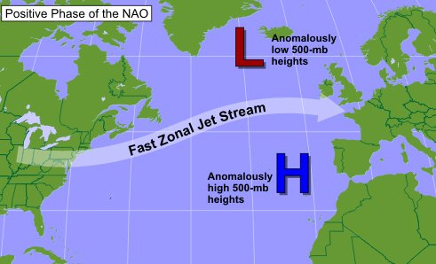
That was due to the northern vort flattening out. The culprit? The NAO. It was Positive. The Strong HP near Western Africa and Portugal and a strong low pressure at Northern Europe is a classic +NAO signature. That prevents the flow of the trough from slowing down and buckling and the storm will just roll to our south.
.png.6493f7bd80f8923bc21ef9a4798e935d.png)
-
 1
1
-
-
2 minutes ago, LibertyBell said:
Better question is why are we getting shut out for December even though it hasn't been all that warm. We've had a stormy pattern all month, just no snow lol.
MJO in the warmer phases kept influencing an SE Ridge or a improper alignment between two jet streams. Along with a lack of HLB and almost zero Pacific Ridging at the same.
-
1
-
-
27 Dec 2018 1008.54 1004.50 1.66 9.23 3.48 26 Dec 2018 1008.83 1005.75 -3.32 9.37 3.39 25 Dec 2018 1009.69 1005.60 1.92 9.48 3.37 24 Dec 2018 1010.56 1005.75 5.66 9.41 3.34 23 Dec 2018 1011.65 1005.45 12.87 9.35 3.16 The SOI is hitting the third plateau of intensity. The SOI will waver from neutral to negative in the next several days or so, based on the previous progression.
-
1
-
-
1 hour ago, 78Blizzard said:
From the looks of that, we will be fairly dry the next 2 weeks- just some light rain or showers- with temps AN. I'm closing the shades.
Yup.
.gif.bb8620dff501daa1445a46909edcee6f.gif)
-
1
-
-
Just now, 495weatherguy said:
What would the odds be of a total bust? I’m just asking, I’ve seen it countless times before where we were going to get a huge storm, And we wind up with nothing.
.gif.634583c3b8bcf96a45298a7929a85e1a.gif)
This shows why the stormier than average weather will happen past the 15th.
-
1
-
-
3 minutes ago, 495weatherguy said:
A serious question-if we are going to enter an active, wintry period, say Jan 15-March 1, what are the odds of 40 plus inches of snow during that time frame?
I'd say around 35%. It's more likely that we could get 30" of snowfall during that time period. Although I wouldn't be too sure about that either. At least not yet. We need to see if the high amplitude MJO Phase 7 verifies first.
-
 1
1
-
-
Oh boy. The 15th and onward. Something to be excited about. I'll have analysis on that later.
-
1
-
1
-
-
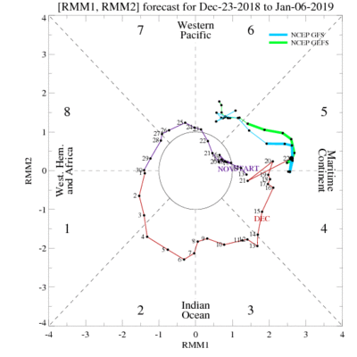
The GEFS still has that mega amplitude like yesterday through Phase 7.
-
1
-
-
38 minutes ago, CIK62 said:
Last 6 days of Dec are averaging 41degs., or 6degs. AN. All 8 days averaging 40degs.
Month to date is +1.1[39.5]. Dec. should end at +2.1[39.9]
EURO is No Snow for 10 days. GEFS is 40% chance of at least 4" by the 11th.
Starting to look a bit bleak.
jk
-
29 minutes ago, LibertyBell said:
Go look at the big Christmas Tree and go ice skating lol.
Can't ice skate. Poor. Also looking at the Christmas tree might make me more depressed. Although I can check it out next Sunday.
-
11 minutes ago, forkyfork said:
happy boxing day
Remembering 8 years ago.
-
3
-
-
1 minute ago, uncle W said:
some el nino years that had most of its snow after January 15th...
season...Jan 15th...After...total
1965-66.........T.........21.4"......21.4"
1968-69........8.0"......22.2"......30.2"
1972-73.........T...........2.8"........2.8"
1977-78........5.6"......45.1"......50.7"
1979-80........5.5"........7.3"......12.8"
1982-83........4.0"......23.2"......27.2"
1986-87........1.1"......22.0"......23.1"
1991-92........0.7"......11.9"......12.6"
1994-95........0.2"......11.6"......11.8"
1997-98.........T...........5.5"........5.5"
2004-05........3.0"......38.0"......41.0"
2006-07..........T........12.4"......12.4"2014-15........3.2"......47.4"......50.4"
2015-16...…..0.2"......32.6"......32.8"
2018-19...…..6.4"
Only match I see for 5"+ of snowfall by the 15th are 68-69, 77-78, and 79-80.
-
1 minute ago, Hailstorm said:
How so? It's Christmas. Nice time to be festive as we come closer the much-anticipated wintry period.
Trying to get in the festive mood. Not feeling it. Maybe I'm getting old?
-
1
-
-
I'm so bored.
-
1 hour ago, CIK62 said:
EURO WEEKLIES have winter beginning Jan. 03 onward. Does not seem too spectacular however. In Jan. we could get away with it and have a snowstorm anyway if the Teleconnections/MJO conspire and the SSW gives us some BN air on our side of the NP. Next 30 on the CFS is 19BN 11AN
But just in case we get the BN air only........does anyone have a list of major snowstorms around here that have occurred with bad Teleconnections/MJO? Thanks in advance.
This sounds ominous.
-
12 minutes ago, snowman19 said:
Sure, I think it’s cold/snowy starting in mid-January (1/15 or so) through mid to late February and that’s it. I don’t think March is cold/snowy this time around. The +QBO should be strengthening and decended into the lower stratosphere at that point, I think the high latitude blocking breaks down, pattern retrogrades and it’s onto spring by early March
That sounds reasonable. Also very good analysis.
-
33 minutes ago, NEG NAO said:
can you elaborate ?
.thumb.png.c4f4914624bb18d0d5a5f8e46a51929f.png)
The transition period starts on the 4th for the NAO region. The PNA is sufficient, yet decreasing in heights. The EPO is also decreasing. Based on the MJO, the amplitude for Phase 5/6 is below 2.00, so this would result in a muted ridge for the SE US. At the same time, the strong blocking from the Northern Atlantic will loosen up a bit. Which will allow for a more northerly track. This could mean a Miller B, but Southern New England and Northern New England could receive the most snowfall from this. However, this doesn't mean that the block will loosen enough for an inland runner. IMO, I think this could range from a Coastal Runner to a scraper, depending on the intensity of the East Based NAO and the position of the ridge for both the West and East Coasts.
-
1
-
-
1 minute ago, Dan76 said:
Where's the Jan thread ? Looking at dec in the rear view now.
I agree. Although I think maybe a few more days. At the 29th?
-
On 12/22/2018 at 5:33 PM, AfewUniversesBelowNormal said:
Continuing the theme, there is a +land torque signal in Northern Europe. Analogs show a poleward progression of the warmth.


Now things may finally get interesting for the Eastern 2/3rds. Just need the Pacific to cooperate.
-
1
-
-
58 minutes ago, tim said:
...'some people are weatherwise..most are otherwise'..benjamin franklin..circa1780's.
I'd watch out for the first week of January. There's a legit signal for a SECS at that window. Somewhere around the 4th-7th.
-
1
-
-
34 minutes ago, bluewave said:
We are getting the classic mild December El Niño ridge over North America. But the continuing +SOI is associated with an extension of the La Niña ridge north of Hawaii. So the jet configuration is different across the North Pacific than is typically the case in an El Niño December. Stronger jet max further to the north.
The SOI has leveled out and it's slowly falling. So the SOI probably just encountered its' secondary max.
-
The fact that December is ending above average already proves that the La Niña-esque weather pattern is coming to an end. So yeah, bring on the mild end of December.
.png.45903f7cfdbe1bda1140138b5740a51b.png)
December 2018 General Discussion & Observations
in New York City Metro
Posted
Finished with 11.6" of snowfall.