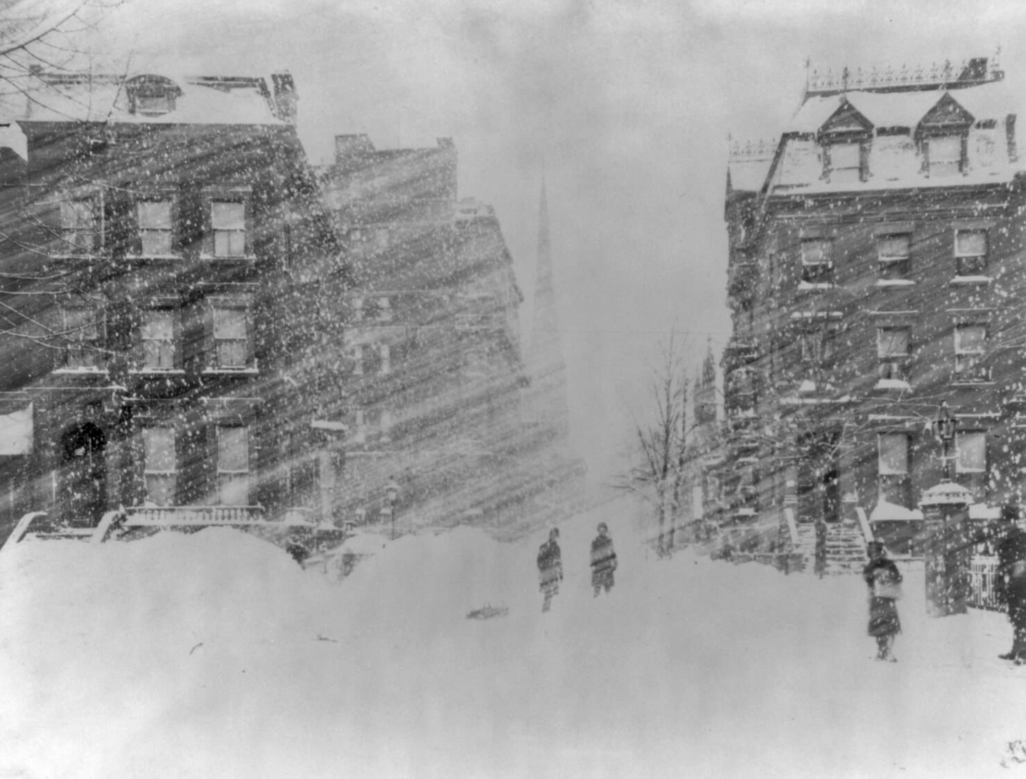

IntenseBlizzard2014
-
Posts
3,188 -
Joined
-
Last visited
Content Type
Profiles
Blogs
Forums
American Weather
Media Demo
Store
Gallery
Posts posted by IntenseBlizzard2014
-
-
I've been tracking East Coast Winter Storms for quite a while, and what I've seen from the UKMET was quite an eye-opener.
-
 3
3
-
 1
1
-
 1
1
-
-
The 00Z GEFS looks like puke. Although, based on the latest shifts, I wouldn't be surprised if the GFS OP/GEFS made large adjustments by 06Z.
-
The 06Z GFS really wanted to rush the storm. The H5 vort closed off over NJ while remaining Positive tilted. This would benefit the coast quite a bit, but alas the amount of snowfall would be cut down further inland (Southern NY and NE PA) vs 00Z. Seems like EPA will get the goods on this run.
-
6 minutes ago, Fishmn said:
I hate being in the bullseye 5 days out. At least is something after a 3 year drought.
It's actually 3.5 days away.
-
1 hour ago, CIK62 said:
Next 8 days are averaging 36.5degs., or about 1deg. AN.
Month to date is -1.5[38.0]. Should be about -0.7[37.6] by the 27th.
16* here at 6am.
None of our major models has any fun and games for the next 8 to 10 days, either snow wise or T-wise. What is a board (bored) suppose to do?
Maybe this our chance to take a well-deserved break?
-
The QBO value is nearing the -5 to +5 range. The QBO value as of November 2019 is +5.07. Let's see if the QBO can go a little lower for December.
-
Just now, winterwx21 said:
I don't see what's so funny. There's a reason why it hasn't been accumulating on pavement here despite 1 to 2 inch per hour snowfall rates and 33 degrees. If we had this at night we'd have a couple inches on the pavement right now.
It's probably the snow growth. It's not exactly impressive area-wide. Some people are getting huge snowflakes. Others are not.
-
52 minutes ago, Eduardo said:
Sounds like last year. Closed the shades after the first weekend of December and never opened them back up. Hoping we don’t endure the same MJO madness this year.
Broadly-speaking, seems like we are planting a fork in the road—one way leads toward a 2013-14-type our once and the other takes us toward 2018-19’s lair of doom. Is that somewhat accurate?
If there are disruptions on the stratospheric and tropospheric levels of the PV up north through late December, then there should be a window of opportunity through mid January into mid February.
-
1 hour ago, White Gorilla said:
Many more Euro solutions to go, but yeah, that map makes sense just based on climo alone
Yeah. I'd be cautious about this one for the coast. The primary low not transferring quick enough is one scenario that's glaringly bad for the coast. Another problem is dry-slotting.
-
5 hours ago, bluewave said:
Yeah, record cold temperatures now in the stratosphere above Finland.
Yeah. I gotta admit, this winter looks like a rickety bridge because of this and the very warm IOD.
-
2 hours ago, bkviking said:
Isotherms winter forecast out
I had a feeling it wasn't going to look good. The IOD doesn't look impressive for us. Nor does the NAO.
-
 1
1
-
-
56 minutes ago, SnoSki14 said:
Wow the EPS has a massive torch for us in about 9-10 days. That's easily 80s, maybe even a stray 90F in there.
Downright scary how often these record breaking torches are showing up.
I'd say that up to 74 is more likely. Even in a super warm month like October of 2007 didn't have highs near 90 in the second half of October.
-
1
-
-
1 hour ago, SACRUS said:

We really dodged a bullet. If Sub-Tropical Storm Melissa was 350 miles further west, we'd be talking about heavy rain and high winds with insane wave heights.
-
-
8 hours ago, IntenseBlizzard2014 said:
That's will kick up a massive ridge for a few days.
Seriously though. The West Coast will chill out while the East will torch. The EURO says definitely to that.
-
3 hours ago, sferic said:
Excuse my ignorance, but is this for cold weather lovers?
That's will kick up a massive ridge for a few days.
-
1
-
-
2 hours ago, Brian5671 said:
tropics globally just completely dead. Guess there's more to it than the warm oceans right now...
Yeah. The atmosphere requires constant instability for tropical activity. The dry air is also a major problem.
-
5 hours ago, NYCweatherNOW said:
Gfs is showing that tonight delayed and minor heat.
Yeah. The next round of heat may max out in the low 90s, but nothing like a couple of weeks ago.
-
On 7/17/2019 at 9:37 AM, Stormlover74 said:
I don't get those. I haven't seen a house centipede in my current house either. Those things freak me out because they're so damn fast
One ran on my bare leg and then scooted off my chair.
-
 1
1
-
-
The heat is interfering with the network communications in the MTA subway systems.
-
2 hours ago, bluewave said:
12z Euro has quite a surge of major heat and humidity after the Barry remnants on Thursday.


Yeah. This is legit death heat level.
-
On 6/26/2019 at 7:03 AM, bluewave said:
They were both the strongest of their class for the South Shore of Nassau.
An intense line of severe thunderstorms oriented from north to south developed during Labor Day afternoon ahead of a strong approaching cold front. As the storms moved east at 40 to 50 mph, they produced high winds, large hail, and an isolated tornado. Wind gusts from 60 to 80 mph downed many trees and power lines throughout the area. The cost estimates of damage included above are preliminary figures submitted by the Nassau County Office of Emergency Management.
In Richmond County, the following peak wind gusts were reported: 80 mph at Great Kills, the Verranzano Bridge, and in Richmond. High winds downed trees and caused a building to collapse in Richmond. One tree fell on and injured a man in Richmond.
In New York County (Manhattan), high winds caused a building to collapse.
In the Bronx, high winds downed a tree that fell on 3 people resulting in 1 death and 2 injuries in the courtyard of the Edenwald Houses at 1135 East 229th Street.
In Kings County (Brooklyn), high winds downed and uprooted several large trees. One tree fell on and injured a person at East 229th Street. Five to 6-foot diameter trees were uprooted east of Coney Island in the Gerritsen Beach Section, where 3 funnel clouds were also sighted and a firefighter was injured from large hail. Large trees also fell on and damaged cars in Bensonhurst.
In Queens County, a peak wind gust of 62 mph was measured at both LaGuardia Airport and at JFK Airport.
In Nassau County, the following peak wind gusts were reported: 75 mph in Farmingdale, 60 mph in Port Washington and Mineola and 58 mph at Farmingdale Republic Airport. High winds downed large tree limbs at Rockville Center, Baldwin, and Oceanside and downed trees in Long Beach, Massapequa, and Valley Stream. One-inch diameter hail dented cars and covered the ground in Farmingdale.
In Suffolk County, high winds overturned many boats in the Great South Bay, downed large trees in West Babylon and Rocky Point and downed large tree limbs in Wading River. One person died when a thunderstorm wind gust capsized a 19 foot sail boat in Great South Bay near Copiague. A Centerport woman, 36, and her daughter, 3, were injured when a tree fell on them in the parking lot of the Ground Round Restaurant and CVS on Fort Salonga Road. The following peak wind gusts were reported: 72 mph in Babylon and 65 mph in Fire Island.The NWS confirmed that an F2 tornado was responsible for significant damage that occurred in Lynbrook. Most of the village received damage from straight line winds up to 80 mph, that was associated with a severe squall line. Downed trees covered the village with some structural damage where the F2 tornado touched down.
The major path of damage was from the northwest section of Lynbrook east-southeast to the southeast section of the village. Funnel clouds were observed from near the intersection of Marshall Ave. and Burtis Street and to the southeast. A tornado was first sighted by two eyewitnesses on Hampton Place. It rose and touched down several times: Second, near Winter Street and across Glover Circle; Third, along Peninsula Blvd. between Earle and Benton Avenues; and Fourth, as a weak F2 near the intersection of Rocklyn Ave. and Merrick Road. It moved across the Long Island Railroad Tracks and Sunrise Highway before it finally dissipated.
More than three hundred trees were blown over, many on houses and cars. Six people received minor injuries. Four of these were in "The Fun Zone" on Rocklyn Avenue. One woman was slightly injured by a tree that fell on her car. One police officer was also injured.I remember this. I was in Hackensack, NJ at the time. My little 7-year-old mind was astounded by this event.
-
1
-
-
It's becoming increasingly clear that oppressively humid summers are here to stay.
-
1
-
-
Dewpoints are dropping here.
-
1
-


January 28-30th Possible Nor'easter
in New York City Metro
Posted
One thing that caught my attention was that the 06Z NAM had a closed-off H5 Low at Delaware's Latitude. That's probably why the snowfall pushed further inland this time.