

marsman
-
Posts
318 -
Joined
-
Last visited
Content Type
Profiles
Blogs
Forums
American Weather
Media Demo
Store
Gallery
Posts posted by marsman
-
-
15 hours ago, Iceagewhereartthou said:


Headed to the coast for Labor Day weekend... this might make it windy.
-
52 minutes ago, NorthHillsWx said:
Best storm of the year right now.

Edit: Wind gusts probably 40-45, torrential rain, and absolutely non stop lightning. Still going strong, did not expect this todayCary rain/snow hole at 100%, no precip IMBY. Outflow has cooled things off nicely though.
-
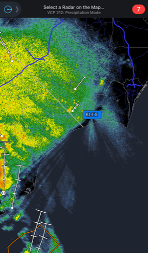
Mentioned in this thread, I think the issue with the KLTX radar and trees was very noticeable early this morning
-
 1
1
-
-
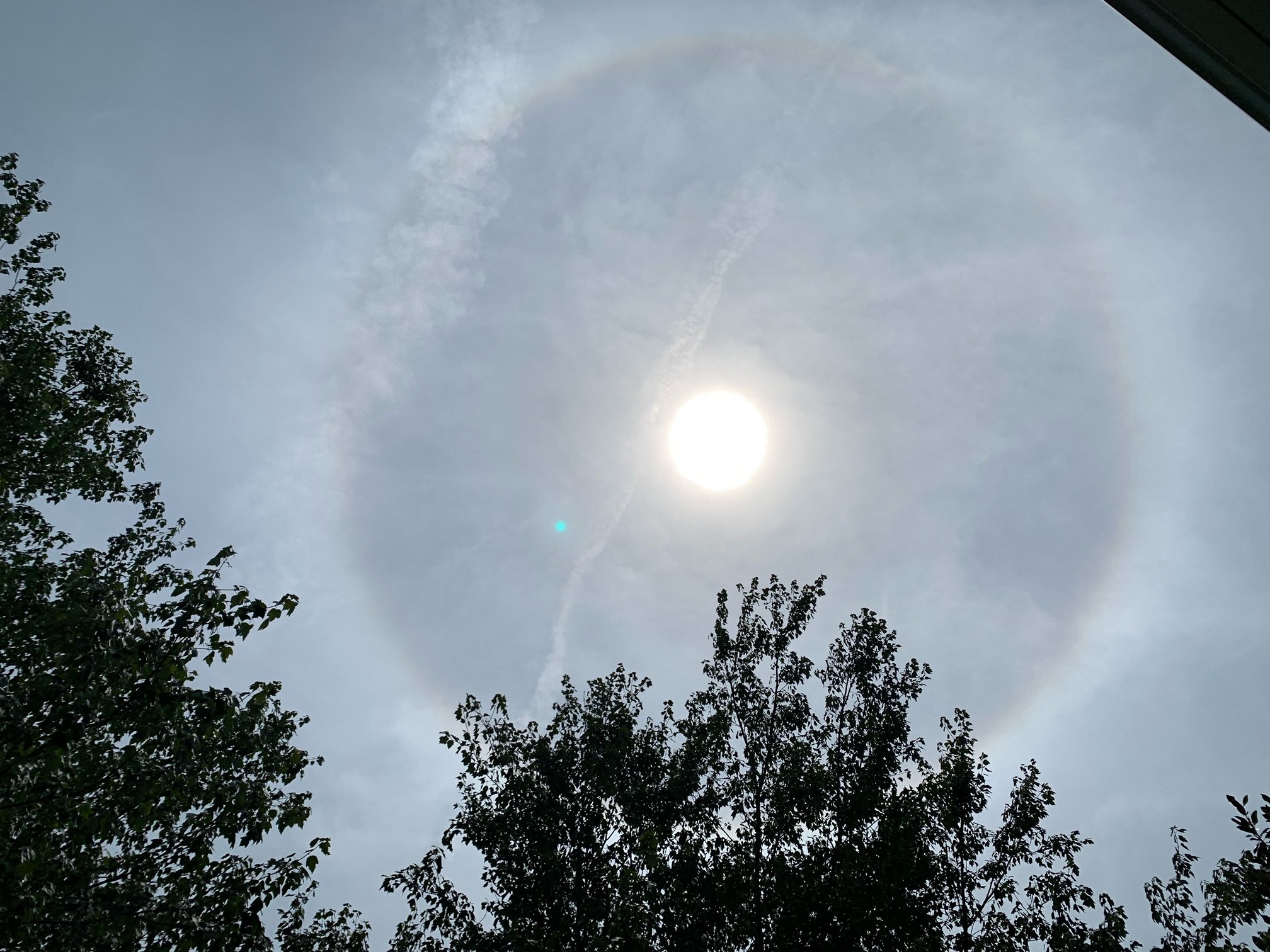
93.9F in Cary. High clouds bringing a sun halo.

-
Harkers Island reporting 5.4" since midnight and counting.
-
Pines do grow tall, that's nothing new. Looking on street view the radar looks low for the area:
I'm not an expert on lumber, but I understand the prices are very high right now, maybe even for pine. That might be an incentive for the landowner to cut the trees.
-
.11" in the bucket. 95.8 for a high early a little after 1pm.
-
1
-
-
Quote
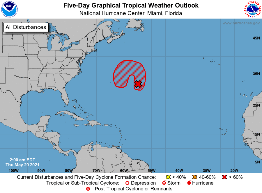
800 AM EDT Thu May 20 2021

For the North Atlantic...Caribbean Sea and the Gulf of Mexico:

1. A non-tropical low pressure system is located about 800 miles east
of Bermuda.  The low is expected to develop gale-force winds later
today while it moves generally northward. The low is then forecast
to move westward and southwestward over warmer waters tonight and
Friday, and it will likely become a subtropical cyclone near and to
the northeast of Bermuda on Friday. The system is expected to move
toward the north and northeast into a more hostile environment by
late Sunday into Monday. For more information on this developing low
pressure area, please see High Seas forecasts issued by the NOAA
Ocean Prediction Center and forecast products issued by the Bermuda
Weather Service.
* Formation chance through 48 hours...high...70 percent.
* Formation chance through 5 days...high...90 percent.
-
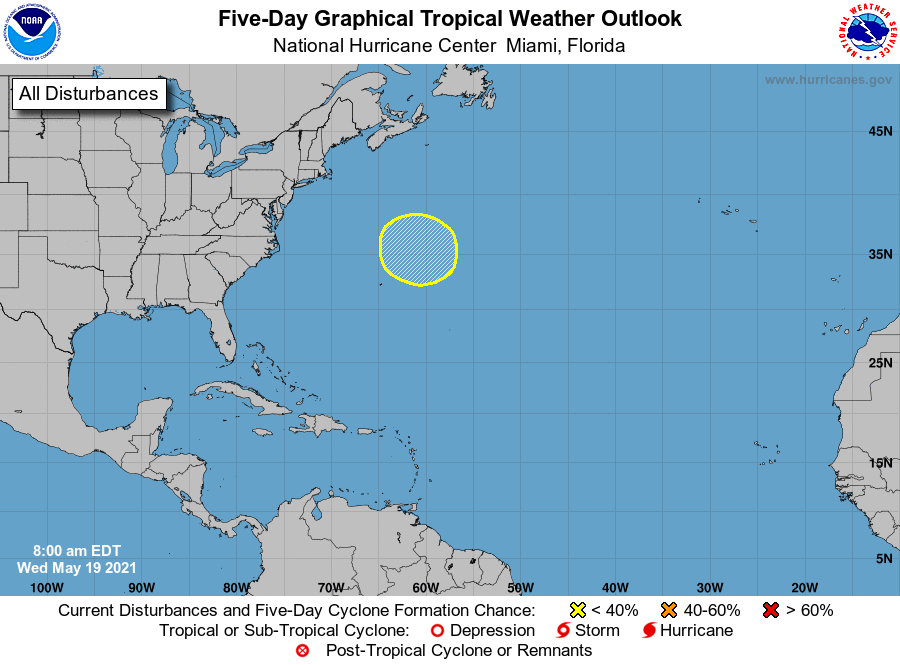
30% on the 5-day:
1. A non-tropical low pressure system is forecast to develop a few
hundred miles northeast of Bermuda by late Thursday and produce
gale-force winds. The low could then move southwestward over warmer
waters on Friday and acquire some subtropical characteristics
before the system moves toward the north and northeast into a more
hostile environment by Sunday.
* Formation chance through 48 hours...low...near 0 percent.
* Formation chance through 5 days...low...30 percent.
-
Just received the first drops of rain here since....? 77.9F/72 and breezy. As of right now, the trees have still dropped more stuff on the ground today than rain. I hope that changes later!
-
WX station shows 33.2, driveway surface w/ laser thermometer shows 32.8. When I point the thermometer at the trees, about 30-50 feet AGL, the thermometer shows 27-29F.
There's visibly more ice now on top of the high pines and oaks than there was this morning. 0.65" in the bucket.
-
2
-
-
8 minutes ago, MOD said:
Not sure why wake has so many so far, but here is power outage map. https://www.ncdps.gov/power-outages
A few minutes ago the Duke Energy map showed about 2k people without power just north of Fuquay-Varina off US 401. It's not there anymore. https://outagemap.duke-energy.com/#/current-outages/ncsc
-
32.1 in Cary, spots of ice on the deck. The tops of the trees have a good coating of ice, visible on the pines. With the laser thermometer, deck temp reads 29, and the trees show 27.
-
22 minutes ago, davenc said:
Live YT cams in Clayton, Smithfield, and Apex are showing snow falling!
Can anyone verify or is anyone seeing snow mixing in??
"fat rain" in Cary and 33.8F. Was out in yard just before 8am, no sign of anything frozen.
-
 1
1
-
-
Also heard the thunder in Cary. 46F, .10 in the bucket so far.
-
41 minutes ago, WinstonSalemArlington said:
Whoever Forecasted 60 degrees in Winston today should learn a valuable lesson in NC CAD. This afternoon, it’s 37 degrees in Winston-Salem.
44 in Cary...slowly creeping upward. RAH calling for 50.
-
Watching the radar and seeing the precip having issues reaching Wake county. Wondering if that’s the dry slot many mentioned, or if the Uwharries are capable of creating a rain shadow, or both.
-
Low of 27 in Cary this morning. 39 now and sun coming above the trees, remaining patchy frost in the shade is melting. Milk, bread, and TP on hand.
-
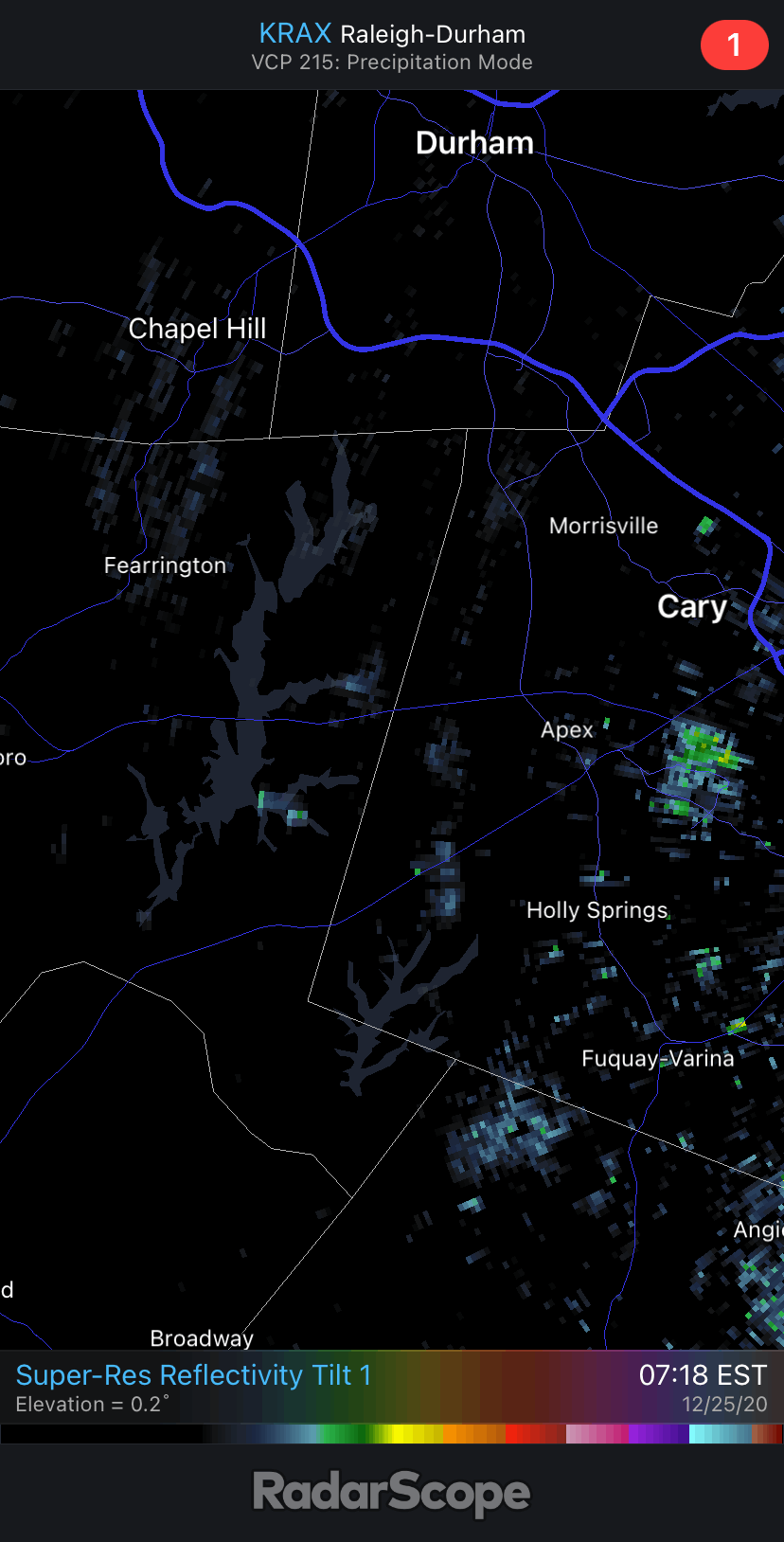
Merry Christmas! A few flurries here just now in Cary. Looking at Radar Scope I could think there’s some lake effect snow coming off Lake Jordan. Looks different than the usual returns I see off the Harris power plant.

-
4
-
-
35F in Cary, mixed precip.
-
2
-
-
.33" last night/this morning. 38F now and temp slowly dropping.
Davis station has the snowflake on it. Cue Jim Carrey "so you're saying there's a chance".
-
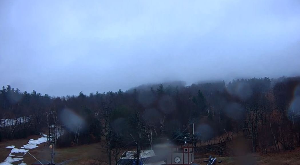
Here's a snap of the Wachusett summit webcam, from moments ago:

-
 1
1
-
-
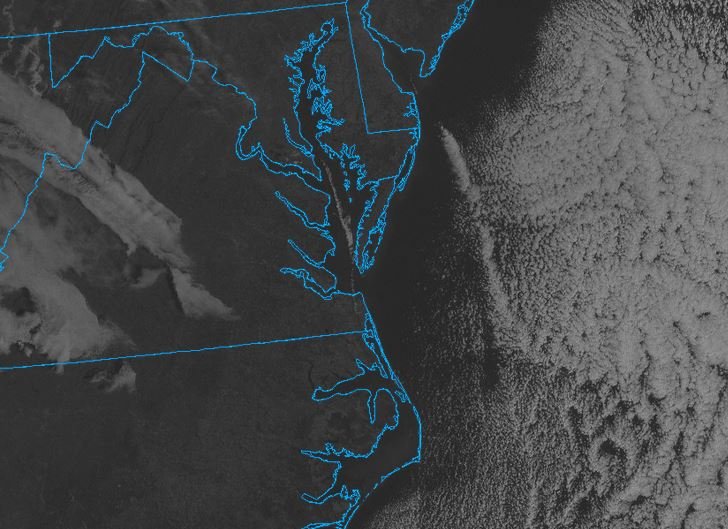
On the satellite, seeing some clouds appear over the waters of the Chesapeake and Delaware bays. Warmer water there? I can't find a detailed SST map for the area.
-
2
-
-
40.5 for a low this morning in Cary.
Ida Banter
in Tropical Headquarters
Posted
Anyone else just lose John Humphress' stream?
https://www.severestudios.com/storm-chasers/john.humphress2.html
edit: nevermind, back up