-
Posts
316 -
Joined
-
Last visited
Content Type
Profiles
Blogs
Forums
American Weather
Media Demo
Store
Gallery
Posts posted by marsman
-
-
1 minute ago, Floydbuster said:
Link?
https://storms.ngs.noaa.gov/storms/ian/index.html#13/26.4579/-82.0780
-
 1
1
-
-
Just now, LongBeachSurfFreak said:
Can someone link it? I don’t have it saved.
Ian definitely build a nice surge on its north side based on buoy readings I have been looking at. That easterly fetch with the high pressure gradient is a very rare setup this far south. Something more like you would see in New England during some of the classic nor’easters. Sc is going to be another major damage area. As JM and I have noted as we both lived in Long Beach Ny, salt water flooding in itself is a disaster as you need to gut down to the studs to properly repair
.Here's one: https://www.severestudios.com/storm-chasers/jordan.hall.html
-
9 minutes ago, Eskimo Joe said:
I was just about to mention this. Lots of planes in the air doing surveys per FlightRadar24. US Customs is also out over the Gulf, my guess is debris survey or stranded boaters.
-
16 hours ago, buckeyefan1 said:
I’ve never been in a tropical storm where heat will be needed

LMAO... and it kicks on in my house, set to 68. 55F outside right now, .34" of rain since midnight.
-
 2
2
-
-
Round 2....... FIGHT.... Gonna say North Myrtle Beach, SC.
-
23 minutes ago, wncsnow said:
I think it's safe to say we won't be seeing another Ian ever. Have to be getting low on I names at this point.
20 minutes ago, olafminesaw said:Gotta start pulling out all the obscure Arabic names
I say we go back to using the Greek Alphabet. If we go over, use AA, AB, AC, etc.
-
-
I just hear the term "Orlando's gonna get coned" on TWC. I've heard "in the cone" but not "coned".
-
Boca Grande, up Charlotte harbor - south of the Rotunda. Follows Peace river upstream.
-
18 hours ago, StantonParkHoya said:
Been bone dry in Raleigh for weeks. We can soak it up.
1 hour ago, calculus1 said:Same here in Hickory, NC. We got 0.62 inch of rainfall last night due to a rogue storm on the frontal passage, but that was the first measurable rainfall in weeks. We need the rain here.
Last measurable rain IMBY was Sept 12th. Only 1.52" for the month so far. Not bothering aerating the lawn, it's hard as a rock.
-
I can't help but notice how much more prominent Cape Coral is on maps these days, even on RadarScope. When I was there many moons ago, I remember it being a big deal that Cape Coral got it's name on an I-75 exit sign.
-
edit - add photos, not sure if FB link works
-
 1
1
-
-
FWIW I was in Morrisville/Briar Creek this afternoon and the Apple Watch said 97... not sure if that data came from KRDU though. High of 96 at the house in south Cary, I can believe 98.
No precip recorded today IMBY, only some good breezes. Currently 76 and falling.
Closer to the coast, nasty looking "S" shaped cell near NWS Newport right now. Should make for some interesting winds and waves tomorrow.
-
High of 96 at 2:10pm. Currently 89 and waiting for either some showers or outflow. Not hopeful for much badly needed precipitation. Last measurable amount was .06" on September 12th.
-
The NHC's "squished-Mercator-ish" map (I'm no cartographer) looks really weird when it has to be stretched from the mid-Atlantic to the Arctic Circle. I also noticed they didn't bother marking the wind speed probabilities above 60N. First time I think I've seen that cutoff.
-
 1
1
-
-
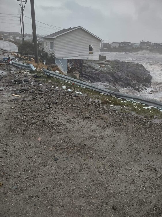
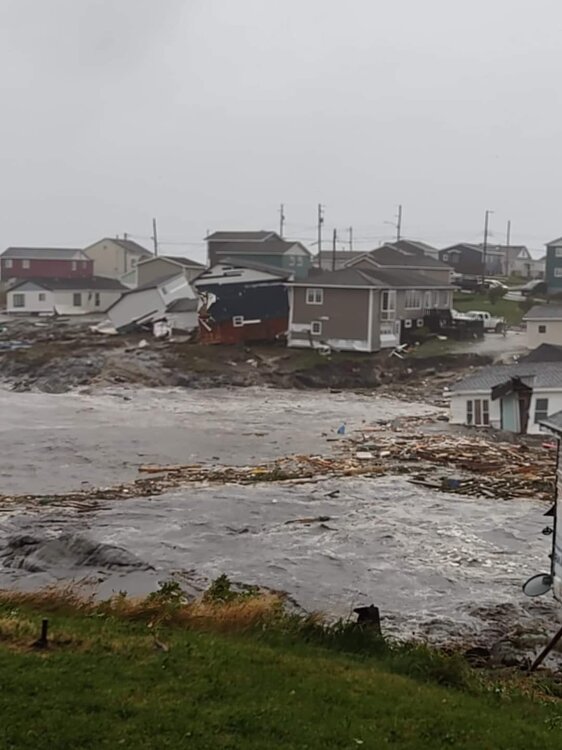
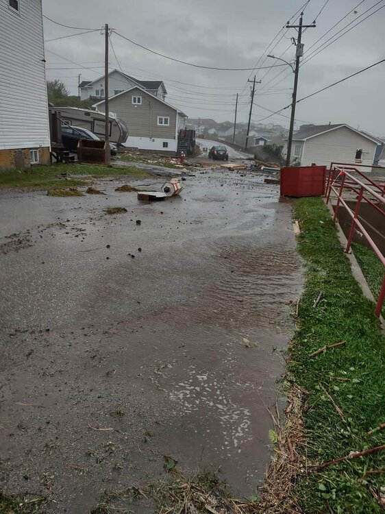
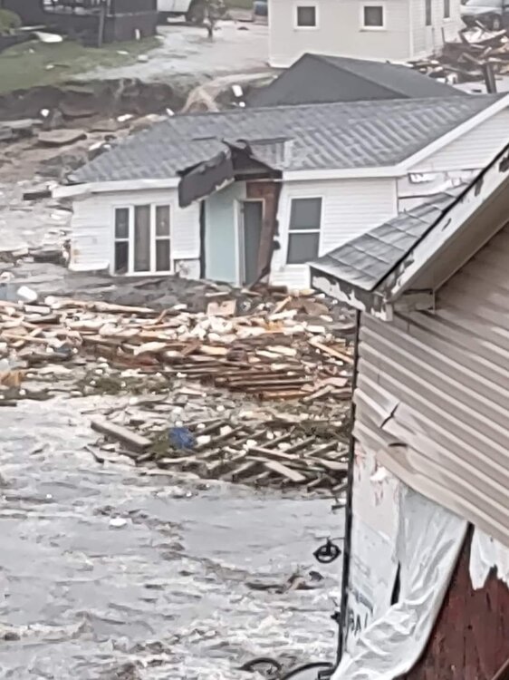
From Canadian Hurricane Centre: 4-8" of rain and 30+ foot waves in the Gulf of St. Lawrence
Quote....
Fiona expected to impact Atlantic Canada and eastern Quebec with heavy rainfall and powerful hurricane force winds for the start of the weekend.
.....
2. Public weather impacts and warnings summary.
This storm is shaping up to be a potentially severe event for Atlantic Canada. Numerous weather models are quite consistent in their prediction of what we call a deep hybrid low pressure system, possessing both tropical and intense winter storm-type properties (but with very heavy rainfall and severe winds).
The latest forecast guidance brings hurricane Fiona off-shore to the south of Nova Scotia Friday night, passing through eastern Nova Scotia and Cape Breton Saturday, and then reaching the Lower Quebec North Shore and Southeastern Labrador early Sunday. Severe winds and rainfall will have major impacts for eastern Prince Edward Island, eastern Nova Scotia, western Newfoundland, eastern Quebec, and southeastern Labrador. There will also be large waves, especially for the Atlantic coasts of Nova Scotia and Newfoundland and eastern portions of the Gulf of St. Lawrence. Finally, there is a high likelihood of storm surge for parts of Nova Scotia, Gulf of St. Lawrence and Newfoundland.
a. Wind.
Most regions will experience some hurricane force winds. These severe winds will begin impacting the region late Friday and continue on Saturday. Similar cyclones of this nature have produced structural damage to buildings. Construction sites may be particularly vulnerable. Wind impacts will likely be enhanced by foliage on the trees, potentially causing prolonged utility outages
b. Rainfall.
Rainfall will be significant, especially north and west of Fiona's track, where heavy rainfall could lead to flooding. the highest rainfall amounts are likely for eastern Nova Scotia, southwestern Newfoundland and the Gulf of St. Lawrence region. Forecast guidance is suggesting widespread amounts of 100 to 200 mm, but closer to the path of Fiona, more than 200 mm is likely. Some districts have received large quantities of rain recently, and excessive runoff may exacerbate the flooding potential.
c. Surge/Waves.
There will also be some rough and pounding surf, especially for parts of Nova Scotia and Newfoundland. Large waves will reach the eastern shore of Nova Scotia Friday night and build to more than 10 metres. These waves will likely reach southern Newfoundland by Saturday morning. Some of the waves over eastern portions of the Gulf of St. Lawrence could be higher than 7 metres. Waves will break higher along some of the coastlines, and dangerous rip currents are likely. Storm surge will also be a threat, for parts of Nova Scotia, Prince Edward Island, including Northumberland Strait, Gulf of St. Lawrence region including Iles-de-la-Madeleine, and southwest Newfoundland, but it is too early to provide details on which portions of the coastline may be affected the most.
3. Marine weather impacts and warnings summary.
Hurricane force southeasterlies should spread into Scotian Slope waters Friday evening, these hurricane force southeasterlies will persist near and south of the track. As the storm moves into the Maritimes, storm to hurricane force northwesterlies will likely develop behind it. Waves in excess of 12 metres should form south and east of the hurricane track, beginning Friday night. These large waves will likely reach the south coast of Newfoundland early Saturday, and parts of the Gulf of St. Lawrence later Saturday.
Forecaster(s): Clements/Couturier.QuoteFXCN31 CWHX 211800 Tropical cyclone technical information statement issued by the Canadian Hurricane Centre of Environment Canada at 3.10 PM ADT Wednesday 21 September 2022. The next statement will be issued by 9.00 PM ADT 1. Current position, strength, central pressure and motion At 3.00 PM ADT, hurricane Fiona was located near latitude 25.1 N and longitude 71.7 W, about 571 nautical miles or 1058 km southwest of Bermuda. Maximum sustained winds are estimated at 115 knots (213 km/h) and central pressure at 937 MB. Fiona is moving north at 7 knots (13 km/h). 2. Forecast position, central pressure and strength Date time lat lon MSLP Max wind ADT MB kts kmh Sep 21 3.00 PM 25.1N 71.7W 937 115 213 Sep 22 3.00 AM 27.2N 71.0W 936 120 222 Sep 22 3.00 PM 29.7N 69.7W 936 120 222 Sep 23 3.00 AM 32.4N 67.4W 936 120 222 Sep 23 3.00 PM 36.9N 64.1W 937 115 213 Sep 24 3.00 AM 43.3N 61.2W 936 100 185 Sep 24 3.00 PM 46.9N 60.4W 935 70 130 post-tropical Sep 25 3.00 AM 50.0N 60.1W 942 60 111 post-tropical Sep 25 3.00 PM 53.0N 59.8W 952 45 83 post-tropical Sep 26 3.00 AM 56.0N 59.4W 963 40 74 post-tropical 3. Technical discussion A. Analysis Fiona, a category 4 hurricane, is continuing northward. The once well defined eye has been filling with cloud on satellite over the last few hours. Vigorous convection is continuing to wrap around the centre, with satellite derived cloud top temperatures nearing - 80c in the northwestern quadrant. An area of convection well to the northeast of the centre is also evident on satellite at this time. Maximum sustained winds are held at 115 kts, and the central pressure is estimated at 937 MB. The motion is northward at 7 knots. B. Prognostic The environment will likely support slight intensification in the next day or so, as the hurricane travels in a moist environment over very warm waters under light to moderate wind shear. Beyond 18 hours, the model consensus begins to accelerate as an upper trough approaches from the west, bringing the hurricane near Sable Island Friday night as it undergoes extra-tropical transition. Then post-tropical storm Fiona is expected to make landfall over Cape Breton Island Saturday morning while maintaining sustained hurricane force winds. The forecast track has been shifted slighty westward with this update, to reflect the tight clustering of guidance ensemble members over Northern Cape Breton. The cumulative qpf field from the rdps/gdps suite is indicating a pre-cursor rainfall event well ahead of the centre beginning as early as Friday morning or afternoon. Rainfall totals suggested by the main models is showing more than 200 mm north and northwest of the track. C. Predicted wind radii (NM) Time gales storms hurricane NE SE SW NW NE SE SW NW NE SE SW NW 21/18Z 145 140 90 125 75 65 45 60 40 35 25 35 22/06Z 160 160 110 135 80 80 55 65 45 45 35 40 22/18Z 180 185 130 145 90 90 65 75 50 50 35 50 23/06Z 200 205 155 155 100 100 80 80 55 50 30 45 23/18Z 215 225 195 180 110 115 95 90 65 50 15 35 24/06Z 395 430 360 350 260 250 210 220 140 130 95 110 24/18Z 370 370 380 320 130 160 150 180 65 60 0 20 25/06Z 360 300 300 250 70 90 30 0 0 0 0 0 25/18Z 120 160 115 160 0 0 0 0 0 0 0 0 26/06Z 20 100 20 100 0 0 0 0 0 0 0 0 END/COUTURIER/CLEMENTS
-
First 50's of the season IMBY, low of 57 this morning at 7am. Windows wide open!
-
High of 86 today with .29" of rain. Felt like mid-July. Looking forward to the week ahead. Meanwhile, my maple trees have shed about 30% of their leaves. I don't see any signs of disease, my first thought is the worse than usual flood/drought pattern this year.
-
Only .07" from the passing showers. High of 90.7 at 4:20pm.
-
Closed out August with 4.08" of rain. Monthly high of 98.2 on August 3rd, low of 60.0 on August 13th.
As for today, 63.4 at 7:15am this morning. Dare I say - a little chill for shorts and flip flops!
Looking back at 2021, September gave me my first fall 40's with a low of 49 on September 24th. Firewood ready!
-
2 hours ago, NorthHillsWx said:
Would be absolutely comical if the LAST possible advisory for August featured a system
If that happens they should name the system Rich Strike - that horse that almost no one expected to win the Kentucky Derby.
-
7 minutes ago, cptcatz said:
Very interesting last frame of the Euro model... intensifies from 986 to 973 while moving southwest.
Andrew-esque
-
 1
1
-
-
Washington Post (paywall): What would happen if Category 5 Hurricane Andrew hit Florida today
-
 1
1
-
-
1.38" total for yesterday.
.90" from a surprise morning storm, something else I haven't seen in a long time.


Hurricane Ian
in Tropical Headquarters
Posted
Upslope effect from the plains to the Piedmont?