

marsman
-
Posts
318 -
Joined
-
Last visited
Content Type
Profiles
Blogs
Forums
American Weather
Media Demo
Store
Gallery
Posts posted by marsman
-
-
1.38" total for yesterday.
.90" from a surprise morning storm, something else I haven't seen in a long time.
-
Getting Tampa, FL level lighting right now, something I haven't seen in 20+ years.
.97" in the past hour of rain, and counting.
-
.36" of rain yesterday! Good chances for more tomorrow and Friday. I'll take it.
-
0.03" of rain so far this month. Currently 94.4F, dew 76F at 1830 hrs on 8 August.
-
16 hours ago, Ed, snow and hurricane fan said:
Just the usual reminder that even in dead seasons like 1983 and 1992, major hurricanes can still hit population centers. 'A' storms that formed in August. 1992 a Cat 5 just South of MIA and a Cat 3 near KPTN.
I was in FL for Andrew. Took some growing up to realize that was late for an "A" storm. Lots of lessons learned from that storm, one of them for me was putting tape on the windows doesn't do anything and is a b**** to remove in the post-storm heat and humidity. Family still throws their plastic patio furniture in the pool though, fun memories of sitting in underwater chairs.
-
On 7/24/2022 at 1:04 PM, NorthHillsWx said:
Wow what a difference being on the other side of the city makes. We’re at 6.32” and places north of here have more than that
I was out of town and missed the first good rain we had in a while on Saturday the 23rd (.31"). Picked up .50" yesterday and .20" today.
-
0.08" of rain so far in July 2022, in the so-called Cary rain hole.
High today of 100.2 IMBY.
Lawn is dead, but meh. Underground watering for the garden is working great.
-
A PWS on Kiawah Island is recording 22mph winds, gusts to 29.
-
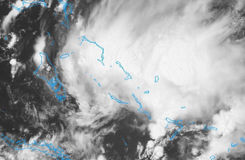
Something (to me anyway) looks interesting in the central Bahamas.
COD satellite link: https://weather.cod.edu/satrad/?parms=subregional-Bahamas-02-24-1-100-1&checked=map&colorbar=undefined
-
Watching the Pikes Peak Hill Climb, loved seeing the snow on the top.
Many friends have braved the spectator experience there and have experienced lightning, snow, and hail that took out a lot of glass.
-
100.0 at 3:10pm
-
Good line right now in the RDU area. So far picked up .14 as of 5:30pm. It was mostly sun with that "here's some more humidity" downpours for the day.... as it usually is when I have to work outside.
Currently 82F w/ 71 dew at 5:30pm before this line of storms.
-
High of 100F on my station at 5:30pm.
-
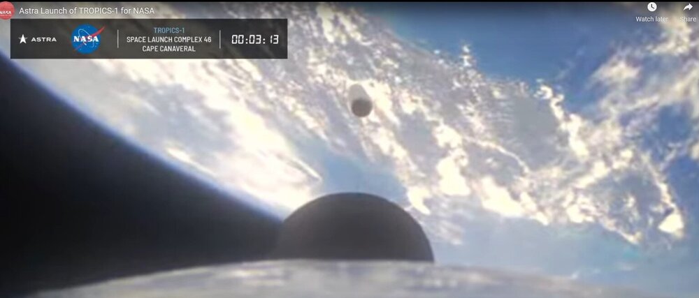
Scott Manley's thoughts:
-
11 minutes ago, cptcatz said:
It did go east. The Astra rocket was not visible from Miami.
Thanks. Here's the screenshot I was talking about - looks [east] of FL, the Keys are visible on the bottom:
-
It went west? The livestream said "a nominal first stage flight". If it did go west that's pretty bad. The brief shot of Florida after first stage separation looked like it did go east.
-
1.38" from this storm today, WRAL says we're going to get another wave tonight. Plenty for the plants & veggies. Very tropical feel to this storm.
Lots of small creek flooding in the area.
-
More pea-sized hail going on right now in Cary. .13" in the bucket for the day so far.
-
In a heavy rain band with pea-sized hail in Cary.
-
11 hours ago, WinstonSalemArlington said:
Interesting - the higher peaks of the west saw an increase, lower elevations saw a decrease. Wonder if warmer temps caused that.
-
Starting to see pollen on the cars. That wind today had it blowing off the pines.

-
34F and rain in Cary, .05" in the bucket. Nothing frozen to speak of.
-
NASA's got their U2 flying around the storm at 60k feet:
https://www.flightradar24.com/NASA809/2ab4fe7e
Edit: And a P3 at 15k feet: https://www.flightradar24.com/NASA426/2ab50e24
-
 3
3
-
-
44/26 in Cary with very light drizzle.

Hurricane Andrew - 30 years later
in Tropical Headquarters
Posted
Washington Post (paywall): What would happen if Category 5 Hurricane Andrew hit Florida today