

marsman
-
Posts
317 -
Joined
-
Last visited
Content Type
Profiles
Blogs
Forums
American Weather
Media Demo
Store
Gallery
Posts posted by marsman
-
-
59.3F low at 0745, 85.9F high at 1745.
edit: 0.03" precip in the early overnight hours.
-
6 hours ago, WxSynopsisDavid said:
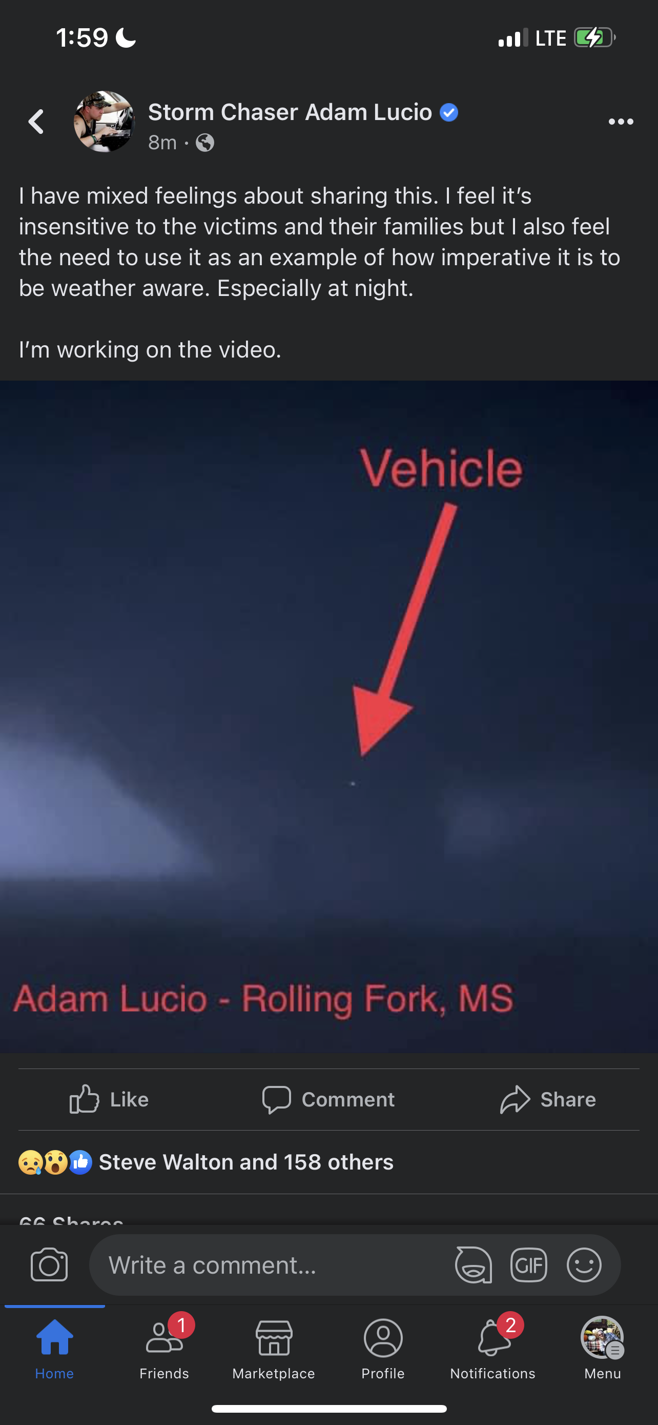
A vehicle got sucked into the tornado and lifted into the upper most portion of the vortice. Adam Lucio has video of the vehicle getting sucked into the vortice, won’t share it due to sensitivity but here’s a screenshot of the vehicle going up into the upper most portion of the vortice.

In his video there are mentions it could be a drone (ffwd to 1:28): https://www.facebook.com/TornadoChasing/videos/590247399819779/
-
10 hours ago, NorthHillsWx said:
Bottomed out at 28.6 this morning. Currently rising at 29.7. Was this the coldest morning we’ll see before next fall?
9 hours ago, StantonParkHoya said:Most likely yes looking at the LR.
27.0 at 0715 this morning, 68.6 at 1700. Days like these remind me of living in Colorado.
-
On 3/12/2023 at 11:44 AM, Chuck said:
Fixed it for you.
We had two 15-minute spats of snow/sleet previously, I think RDU recorded a "T" for one of them. I'm not near my station right now, don't have the specific dates. It was nothing compared to the ~0.25" of slush on my deck yesterday!
-
Sleet/snow earlier, now drizzle in Cary. 35F. Have a little of the frozen stuff on the deck and other elevated surfaces. This is the most winter precip we've had all season.
-
 1
1
-
-
84.4 for a high at 1:30pm. Picked up .03" from the shower passing through. Currently 68F and dropping.
-
High of 81.3 at 1:50pm. Eyes stinging a little and scratchy throat... something that usually happens in March/April.
-
71 for a high today at 1pm. A couple drops of rain, nothing measurable
-
6 hours ago, NorthHillsWx said:
Sometime between Jan 26-Feb 2 will feature a widespread SE winter storm for parts of the forum. You heard it here first folks. #optimistic #turnthatfrownupsidedown
Lock it in...made air reservations today to be out of the area that week. It'll snow, and I'll be delayed in someplace like Chicago trying to get home.
-
 1
1
-
-
Watching the chaos to the SW... first sign of the system here, gust of 15mph came through. High of 68 at 3:15pm.
edit: some drops of rain too, nothing on radar.
-
9.2 at 0745 and climbing now.
-
Power outages ramping up in the area. ~5k in the Triad, ~1k in the Triangle.
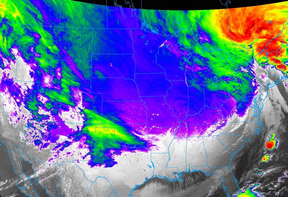
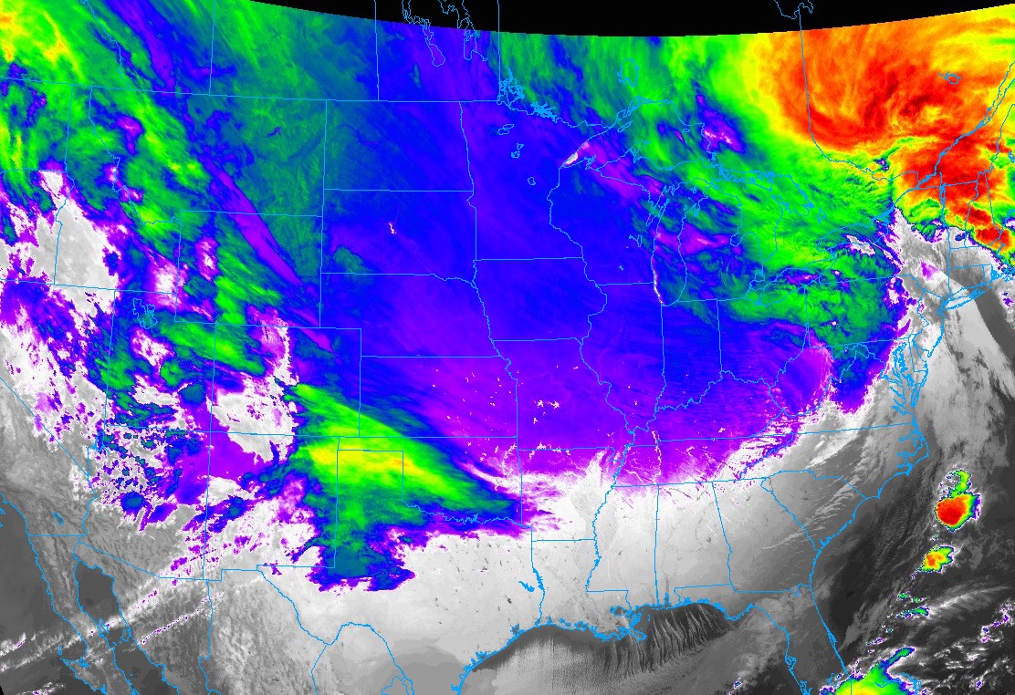
Cold are shows up on the IR satellite: https://weather.cod.edu/satrad/?parms=continental-conus-13-24-0-100-1&checked=map&colorbar=undefined
-
Beech Mountain is closing because of the cold and wind....to all the skiers in here, who do they think they are? Loveland?

-
Very visible on Radarscope:
Marine Weather Statement
National Weather Service Newport/Morehead City NC
344 PM EST Thu Dec 22 2022

AMZ156-158-222115-
/O.CON.KMHX.MA.W.0244.000000T0000Z-221222T2115Z/
344 PM EST Thu Dec 22 2022

...A SPECIAL MARINE WARNING REMAINS IN EFFECT UNTIL 415 PM EST...

For the following areas...
S of Cape Lookout NC to Surf City NC out to 20 nm...
S of Ocracoke Inlet NC to Cape Lookout NC out to 20 nm...

At 344 PM EST, a severe thunderstorm capable of producing waterspouts
was located near The Knuckle Buoy, moving northeast at 30 knots.

HAZARD...Waterspouts, wind gusts in excess of 65 knots, and large
         hail.

SOURCE...Radar indicated.
...
-
Thunder in Cary, and I just realized my rain gauge isn't working...

-
1.06" of rain for the day, high of 46 at 2:30. Lower high temp than expected.
-
38 minutes ago, BuffaloWeather said:


Never forget.... snowball man. '95 Giants-Chargers - this is likely one of the reasons for the move:

-
25.2 for a low at 0645 this morning.
-
Live Snow Plow driver:
-
2
-
-
FWIW looks like Brett Adair is in Buffalo but I can't get any stream to load.
-
Wonder if NASA's gonna roll Artemis back to the VAB. Launch is scheduled for early morning on Monday the 14th.
-
Closed out October with 1.35" of rain, .61" of that was from yesterday.
Storm total is also 1.35".
-
Low of 43 at 8:15 this morning - the high was 59 at 12:15am. Current temp at 56 and dropping. Freeze warning expanded into Wake County for tonight, NWS now calling for a low of 32 IMBY.
-
Accidentally posted this in the Sept thread.....
40.7 for a low this morning. Good chance for 30's next weekend.
April 2023 Obs
in Southeastern States
Posted
Low of 57F at 0645, high of 88F at 1645. A/C is definitely on.