

jojo762
-
Posts
4,228 -
Joined
-
Last visited
Content Type
Profiles
Blogs
Forums
American Weather
Media Demo
Store
Gallery
Everything posted by jojo762
-

MO/KS/AR/OK 2019-2020 Winter Wonderland Discussion
jojo762 replied to JoMo's topic in Central/Western States
The overall trend has indeed been for the heavier swath of snow to be a bit further south, but that specific run was a bit more dramatic with its shift and knocking down of totals. Likewise the very next run shifted back north. Probably won't have anything nailed down better until Monday night, or even Tuesday when we know where the best frontogenesis is occurring. As per usual with winter systems now, my expectations for this storm have gradually kept declining. -
MO/KS/AR/OK 2019-2020 Winter Wonderland Discussion
jojo762 replied to JoMo's topic in Central/Western States
The previous few days of GFS runs all showed KC getting a healthy amount of snow (3"+, something KC hasn't seen in four years)... then the 18Z run comes out and shifts everything further south. Probably just a weird run, but it is definitely odd to see such a shift in a <84 hour forecast. -
MO/KS/AR/OK 2019-2020 Winter Wonderland Discussion
jojo762 replied to JoMo's topic in Central/Western States
Wowzers. Not sure i'm really on board the hype train but 00Z GFS went all in on a big-league snow storm for NE KS/ N MO (including the entire KC metro) for Monday night/Tuesday. Widespread double digit totals. Pretty impressive run, to say the least. But if I have learned anything over the past few years, it is to take more of a tempered approach when it comes to model-output for snow... FWIW, 00z GEM also agrees on a decent snow event for generally the same area, but to a much lesser extent than the GFS. Probably worth noting as well that most of the 00z GEFS members disagreed with OP run on the idea of any kind of major event. -
MO/KS/AR/OK 2019-2020 Winter Wonderland Discussion
jojo762 replied to JoMo's topic in Central/Western States
It's still free on weather.us ... https://weather.us/model-charts/euro/significant-weather.html -
MO/KS/AR/OK 2019-2020 Winter Wonderland Discussion
jojo762 replied to JoMo's topic in Central/Western States
00Z GFS looks like an outlier run for how the trough develops (I.e., no cutoff). Not sure how to take it. Guess we'll see what the EC says later. -
MO/KS/AR/OK 2019-2020 Winter Wonderland Discussion
jojo762 replied to JoMo's topic in Central/Western States
Mike Morgan from KFOR already talking about the possibility of wintry precipitation on Christmas, 11 days away. Such a bad representative for mets everywhere, despite being in a state whose flagship university is known for meteorology. "LATEST LOOK at Christmas Day in OKC. This forecast is based on a LOT of different and constantly changing forecasts from about 150 computer models a DAY. General PATTERN of all of these COLDER with MOISTURE POSSIBLE. Still 12 days away but will track it." https://twitter.com/MikeMorganKFOR/status/941163647463813120 -
MO/KS/AR/OK 2019-2020 Winter Wonderland Discussion
jojo762 replied to JoMo's topic in Central/Western States
Basing off of the relative consistency of the GFS and Euro for the upcoming pattern i'm pretty optimistic about getting some harsh cold and possibly even snow at some point between next week and mid-december. Knowing how these things have evolved the past few years though it'll (the main system(s), whenever it comes through) probably devolve into 33 and rain. Time will tell, but definitely should be some interesting systems/setups coming up. -
MO/KS/AR/OK 2019-2020 Winter Wonderland Discussion
jojo762 replied to JoMo's topic in Central/Western States
lol 12z GFS shows a high-impact blizzard in Colorado and some light snow along the I-70 corridor in KS/MO by D7-8. That came out of nowhere. Verbatim the temp profile appears to support more a mix/very cold rain, but still something to glance at I suppose. -
Before anyone gets too excited or too high on their throne for thinking Maria is going to effect the ECONUS, it should be noted that the King (Euro) is still much further east. Maria is also likely to be a shell of her former self by the time any potential US impact were to occur as she will be moving over cooler waters in the wake of Jose, in addition to an increase in shear.
-
18z GFS brings hurricane conditions to the easternmost outer banks, and TS conditions to far eastern NC. Definitely a good deal further west this run.
-
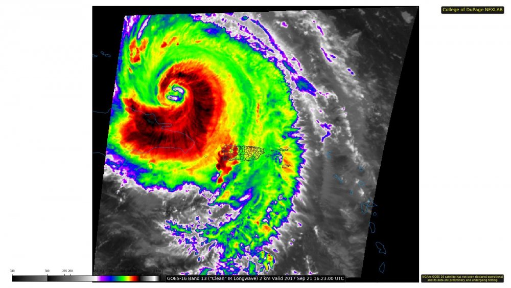
Didn't see the data set from the NHC website... but looks like roughly 120-125kt FL winds in the NW quadrant of Maria per latest recon pass, southeast quad about the same at flight level.
-
Yep... that ULL over the SECONUS really is not nearly strong enough to pull Maria in with how far east she will be.
-
With the NHC OFCL... Both the euro and GFS shows a similar pattern by D5... pretty much game over for this storm. I mean perhaps it get far enough west that it produces TS conditions somewhere along the east coast, but any legit direct impacts are not going to happen unless there is some cataclysmic modeling error.
-
Both the GFS and Euro (the most reliable models when tracking tropical systems) show a very similar evolution of Maria, the ridge(s), and the positively tilted north-CONUS trough... With Maria moving WNW, then north and northeast, then getting trapped under the high and moving a bit more west and north... the ridge then weakens and allows the trough to kick east and capture Maria... Good luck with your thinking.
-
Looks like recon did a lot of flying around in the "eye" trying to find the center... Looks like an extrapolated pressure between 958-959mb... Still holding steady with perhaps some slight strengthening basing off of FL/SFMR winds.
-
Yeah, not too shabby... Not flagged either except for the 2nd to last ob. 162530 2039N 06853W 6964 02958 9861 +098 +098 144113 115 092 034 00 162600 2038N 06854W 6957 02954 9834 +110 +110 145115 117 089 045 00 162630 2038N 06855W 6979 02924 9826 +112 +112 147113 115 097 049 00 162700 2037N 06856W 6955 02930 9803 +112 +112 150110 113 109 050 00 162730 2036N 06857W 6972 02901 9791 +117 +117 153111 113 115 036 00 162800 2035N 06858W 6966 02896 9774 +115 +115 155107 110 112 026 00 162830 2034N 06858W 6974 02875 9763 +115 +115 155108 109 109 021 00 162900 2033N 06859W 6955 02884 9747 +110 //// 154107 108 107 022 01 162930 2032N 06901W 6969 02854 9731 +116 +116 153100 105 104 017 00
-
Well both the NAVGEM and CMC bring Maria into the US but with both the GFS and ECMWF showing an OTS solution, it appears that this is all she wrote... Things could still change, but that seems unlikely... With nothing new to track for the foreseeable future - which has been quite rare recently, as we have had a tropical system in the Atlantic for the past 28 days.
-
One of the more bizarre looking eyes you'll ever see... and likely why there is a double thermal max seen in recon data.
-
Maria moving north of due west between hours 138-144....
-
Safe to call it an OTS'er at this point... but not before causing widespread and significant damage in the Caribbean.
-
Looks like Jose weakens quite a bit on the 18Z GFS, and the ridges appear to connect, but hard to tell if there is still a weakness for Maria to escape OTS or not so far in the run through hr108... IMO steering gets pretty murky on this run by hour 108 as the cyclone slows significantly.
-
Hurricane force FL wind field has expanded dramatically in the past few hours in the SW quadrant it appears, per recon.
-
Absolutely, it's WAY too early to make such statements... regardless of if we see "Tuscaloosa" or "Joplin" or not, the damage caused by legit cat 3 to 5 winds is completely devastating and takes years to recover from fully.
-
Looks like recon just left Curacao.
-
Expected winds and impacts for San Juan... " ...HURRICANE WARNING REMAINS IN EFFECT... * LOCATIONS AFFECTED - San Juan and Vicinity * WIND - LATEST LOCAL FORECAST: Equivalent Cat 3 Hurricane force wind - Peak Wind Forecast: 100-120 mph with gusts to 170 mph - Window for Tropical Storm force winds: early this evening until Thursday morning - Window for Hurricane force winds: early Wednesday morning until Wednesday evening - CURRENT THREAT TO LIFE AND PROPERTY: Extreme - The wind threat has remained nearly steady from the previous assessment. - Emergency plans should include a reasonable threat for major hurricane force wind greater than 110 mph of equivalent Category 3 intensity or higher. - To be safe, aggressively prepare for the potential of devastating to catastrophic wind impacts. Remaining efforts to secure properties should now be brought to completion. - Extremely dangerous and life-threatening wind is possible. Failure to adequately shelter may result in serious injury, loss of life, or immense human suffering. Move to safe shelter before the wind becomes hazardous. - POTENTIAL IMPACTS: Devastating to Catastrophic - Widespread power outages with some areas experiencing long-term outages - Many bridges and access routes connecting barrier islands impassable - Structural category to sturdy buildings with some having complete wall and roof failures - Complete destruction of mobile homes - Numerous roads impassable from large debris"


