jojo762
-
Posts
4,228 -
Joined
-
Last visited
Content Type
Profiles
Blogs
Forums
American Weather
Media Demo
Store
Gallery
Everything posted by jojo762
-
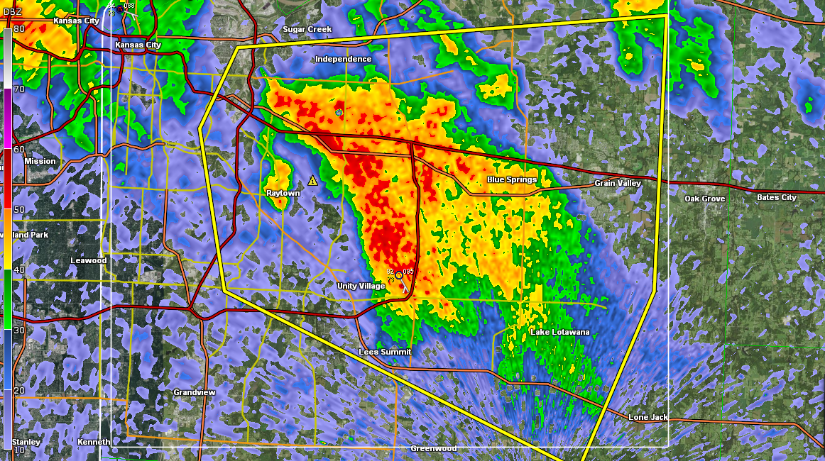
Increasingly impressive supercell developing over KC... Some rotation as well.. TOR Warned now

-
Looks like storms are struggling thus far in the first thirty minutes or so of development. A few cells are showing up on KEAX right now... Most notability a storm over KC, and another storm SW of Carrolton, MO, the Carrolton storm is more interesting looking really, and has exhibited some rotation about 3,000ft up, and also depicts an elongated curved look on radar... Lets see, looks like storms might struggle to become SFC-based... But if they do then it could get at least semi-interesting, with some chance at a few tornadoes. EDIT: TOR watch just got issued.
-
MESOSCALE DISCUSSION 1271 NWS STORM PREDICTION CENTER NORMAN OK 0347 PM CDT WED JUL 01 2015 AREAS AFFECTED...ERN KS...WRN MO AND NRN AR CONCERNING...SEVERE POTENTIAL...WATCH LIKELY VALID 012047Z - 012315Z PROBABILITY OF WATCH ISSUANCE...80 PERCENT SUMMARY...A SEVERE THREAT IS EXPECTED TO DEVELOP ACROSS ERN KS AND WRN MO LATE THIS AFTERNOON INTO EARLY THIS EVENING. LARGE HAIL...WIND DAMAGE AND A COUPLE TORNADOES MAY OCCUR WITH THE STRONGER CELLS. WW ISSUANCE WILL LIKELY BE NEEDED WITHIN THE NEXT 1 TO 2 HOURS ONCE CELLS BEGIN TO INITIATE. DISCUSSION...LATEST SFC ANALYSIS SHOWS A 1006 MB LOW OVER CNTRL KS WITH A QUASI-STATIONARY FRONT EXTENDING EWD FROM THE LOW ACROSS ERN KS AND CNTRL MO. AN AXIS OF STRONG INSTABILITY IS LOCATED FROM NEAR THE BOUNDARY EXTENDING SWD ALONG THE KS-MO STATE LINE WHERE MLCAPE IS ESTIMATED FROM 3000 TO 4000 J/KG. SHORT-TERM MODELS SUGGEST THAT CONVECTION WILL INITIATE WHERE THE INSTABILITY AXIS MEETS THE FRONT WITH THUNDERSTORMS DEVELOPING AND MOVING SSEWD ACROSS ERN KS AND WRN MO. THE MOST LIKELY TIME FOR INITIATION WOULD BE IN THE 2130 TO 2230 TIMEFRAME WHICH IS SUPPORTED BY THE LATEST HRRR RUN. THE WSR-88D VWP AT KANSAS CITY AND SPRINGFIELD SHOW WIND PROFILES FAVORABLE FOR SUPERCELLS WITH 0-6 KM SHEAR NEAR 45 KT AND SUBSTANTIAL DIRECTIONAL SHEAR IN THE 0-3 KM LAYER. THIS COMBINED WITH THE STRONG INSTABILITY SHOULD BE FAVORABLE FOR LARGE HAIL AND WIND DAMAGE. LOOPED HODOGRAPHS ALSO SUGGEST THAT A TORNADO THREAT MAY DEVELOP WITH THE MORE DOMINANT SUPERCELLS. ..BROYLES/HART.. 07/01/2015
-
Missouri, and possibly E/SE KS, looks potentially interesting tomorrow afternoon and evening. SPC has highlighted a SLGT Risk across the area, and mentions supercells being a possiblity, which given the environment seems warranted. 18Z CAM forecast soundings show moderate to extreme instability building across KS/MO with MUCAPE values 3000-5000+J/KG, juxtaposed to relatively impressive directional shear. 0-3KM Shear of 30-40kts/ 0-3KM SRH of 200-400m2/s2, and 0-6KM shear of 40-50kts... Cap really starts to diminish by 21-23Z across much of the area. Appears that CI is likely by 22-23Z across MO pending the results of the morning MCS, and that there isn't a substantial amount of residual cloud cover or any pesky convection on the apex of the dying LLJ/WAA. In the event that there is minimal thermodynamic and kinematic impact from the MCS, convection would likely explode along the boundary/OFB in the form of supercells capable of large hail, with some incidences of very large hail, damaging winds, and a few tornadoes. Eventually growing upscale into a forward propagating MCS capable of large hail and damaging winds... As usual, wherever the OFB from the morning MCS across MO/KS resides is where the highest potential for tornadoes will reside, since LLVL SHR/SRH will be locally maximized. Furthermore, very heavy rain/ flooding will also be of concern evidenced by PWAT's approaching and over 2in, and a morning MCS going over the same area that the afternoon/night storms will go over... 2-5+IN of rain could occur over C MO, basing off of most recent model guidance. and FWIW the 4KM NAM (which is likely over doing the rainfall) has an area of 7+IN across a wide area, and even an area of 11-15IN across C MO by 12Z Thursday, which of course would likely cause a prolific flood concern. EDIT: Also 00Z NAM/4K NAM continue with the same general idea...
-
Pretty strong supercell in NW Nebraska... Actually there are quite a number of impressive supercells/line segments across W NE. Including a TOR warned supercell. ...A SEVERE THUNDERSTORM WARNING REMAINS IN EFFECT UNTIL 515 PM MDT FOR NORTH CENTRAL BOX BUTTE AND SOUTHEASTERN DAWES COUNTIES... AT 500 PM MDT...A SEVERE THUNDERSTORM WAS LOCATED OVER BOX BUTTE CAMPGROUND...OR 25 MILES SOUTH OF CHADRON...MOVING SOUTHEAST AT 40 MPH. THIS IS A VERY DANGEROUS STORM. HAZARD...BASEBALL SIZE HAIL AND 60 MPH WIND GUSTS.
-
A line of storms quickly developed NW of DDC and basically automatically put down a landspout.. Love it. THE NATIONAL WEATHER SERVICE IN DODGE CITY HAS ISSUED A * TORNADO WARNING FOR... CENTRAL HODGEMAN COUNTY IN SOUTHWESTERN KANSAS... * UNTIL 630 PM CDT * AT 600 PM CDT...A CONFIRMED LANDSPOUT TORNADO WAS LOCATED 12 MILES SOUTHWEST OF JETMORE...MOVING EAST AT 25 MPH. HAZARD...TORNADO. SOURCE...PUBLIC CONFIRMED TORNADO. IMPACT...EXPECT DAMAGE TO MOBILE HOMES...ROOFS AND VEHICLES. * THE TORNADO WILL BE NEAR... JETMORE AROUND 615 PM CDT.
-
20Z SPC D1SWO added a small ten percent TOR prob across the watch area.
-
50/20 TOR probs on the TOR watch across SE NE/ NW MO/ SW IA.
-

Central/Western Medium-Long Range Discussion
jojo762 replied to andyhb's topic in Central/Western States
shows an incredible environment in place in S/SE SD and NC/NE Nebraska. 50-70knots of 0-6km shear juxtaposed to MUCAPE of 1000J/KG near the WF to 3000-4000J/KG across the Warm-sector. The environment is especially impressive along the WF in SE/E SD maxed out (500m2/s2) 0-3KM SRH across a large area... Looks as though one issue along the WF could be low-level winds.. Which are kinda meh, AOA 15-20kts along the surface warm front/ theta-E gradient. But further south they increase markedly by 00Z to 40kts at H85 and especially by 03Z to 50kts in C/NC Nebraska... But the LLJ is only slightly south of the front at this point, and this is still several days out so that's only if you take the run verbatim. Another very apparent issue on the soundings is a tremendous cap in place from about 900mb to 700mb, producing CIN around 150J/KG. Nevertheless mid level and upper level winds will not be an issue whatsoever if this were to verify. -
Central/Western Medium-Long Range Discussion
jojo762 replied to andyhb's topic in Central/Western States
00Z GFS definitely doesn't have a significant trough entering the W CONUS... But it does have a pretty significant trough across the far N CONUS (ND/SD/MT) with H5 flow progged at 50-70kts around June 14-15... And this is nearly the exact same scenario as shown by the 18Z GFS, with quite a difference in the 12Z run, and some similarities to the 06Z run... Overall though, the GFS has hinted for a few days at the possibility of some sort of MAJOR trough in mid to late June. -
Central/Western Medium-Long Range Discussion
jojo762 replied to andyhb's topic in Central/Western States
50-70kts of H5 flow over the central plains in early June sounds dreamy... -
Central/Western Medium-Long Range Discussion
jojo762 replied to andyhb's topic in Central/Western States
On a side note, the 12Z GFS develops an odd weak cut-off low around 108hrs over Louisiana. 00Z ECMWF does a similar thing just a day later. Both models just have the feature sitting over LA/the Arklatex for a while seemingly, and don't do anything with it... Also both models are hinting at SW flow beginning in the plains/northern plains toward the end of next week.. Fairly weak trough, but still something.. -
Central/Western Medium-Long Range Discussion
jojo762 replied to andyhb's topic in Central/Western States
well, most of the mid/long-range models (GFS/EURO/UKMET/CFS) forecasts point to quite an active upcoming period in about 7-9 days... So really would disregard the GEM...