

jojo762
-
Posts
4,228 -
Joined
-
Last visited
Content Type
Profiles
Blogs
Forums
American Weather
Media Demo
Store
Gallery
Everything posted by jojo762
-

Central/Western Medium-Long Range Discussion
jojo762 replied to andyhb's topic in Central/Western States
Well looking like our final legit chances in the central plains could be taking shape next week possibly into next weekend, still some timing differences between the euro/GFS, but appears there will be several opportunities for severe storms for at least the northern plains, but probably extending into the central plains on a couple days as well. EML is progged to be quite strong so that will play a big role in how things evolve, but prospects look fairly good with an unseasonably strong mid-level trough ejecting into the N/C Plains. After this period remains a bit uncertain ATTM... But currently leaning toward the inevitable, and dreaded, death ridge developing by ~June 20, likely ending any legit severe/tornado prospects for the central/southern plains for quite some time. -
Central/Western Medium-Long Range Discussion
jojo762 replied to andyhb's topic in Central/Western States
13 tornado reports during one of the most active periods of the year, typically. Only two of which were in the plains... eek. -
Central/Western Medium-Long Range Discussion
jojo762 replied to andyhb's topic in Central/Western States
Some hint from the GFS/GEFS that things could heat up a lot more somewhere cross the plains toward mid-month with appreciable SW flow and abundant moisture... so hopefully that pans out. Not quite in EC or EPS range yet. -
Central/Western Medium-Long Range Discussion
jojo762 replied to andyhb's topic in Central/Western States
This is somewhat reminiscent to 2013 imo as well, especially by Friday/Saturday, H5 map isn't exactly the same but has some similarities, notable differences being the presence of a large NE-trough this go around and the central CONUS trough isn't quite as strong, but other features are similar... Thursday looks mildly interesting, but thinking capping will hinder convective development, and therefore any potential it may have, as of now. GFS has trended with a weaker cap on Friday/saturday, so naturally given the progged thermo/kinematic profile, along with only subtle forcing, those days would both probably be fairly interesting if things were to evolve as shown now (doubtful)... We've all seen what these extreme instability/moderate shear environments have been capable of in the past... -
Central/Western Medium-Long Range Discussion
jojo762 replied to andyhb's topic in Central/Western States
I like our chances of seeing at least SOMETHING the end of this week/weekend... At least one day could be fairly impressive, depending on how a myriad of environmental factors evolve. CIPS GEFS analog percentage for Day 6-8 of at least 10 SVR reports. GFS for several runs has been moderately impressive -- to varying degrees, for a variety of reasons -- for Friday specifically, but Thursday and Saturday could feature severe storms as well. A bit too far out to determine potential hazards really, but the wind profile will be quite favorable for supercells with impressive veering with height.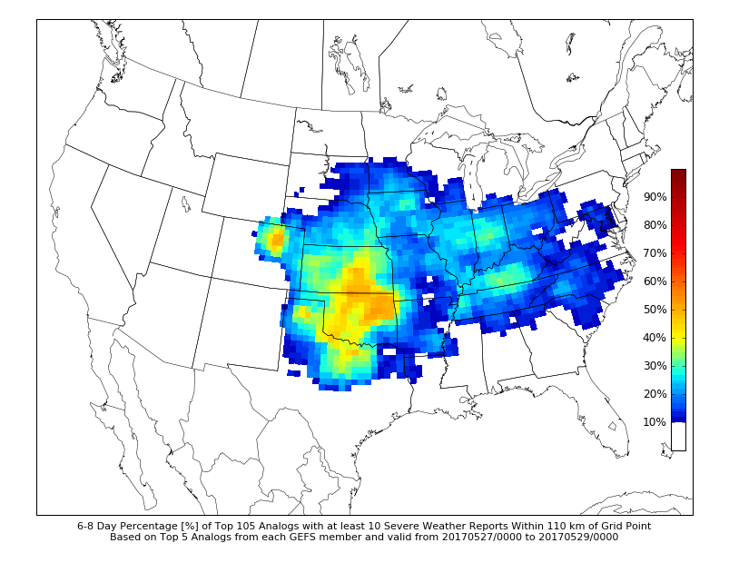
-
Central/Western Medium-Long Range Discussion
jojo762 replied to andyhb's topic in Central/Western States
OUN highlighting how models are starting to converge on at least modest, but potentially somewhat strong, W/SW flow atop moist/unstable environment for multi-day severe threat. -
Central/Western Medium-Long Range Discussion
jojo762 replied to andyhb's topic in Central/Western States
Somebody should go ahead and make a thread for this coming week 5/15-20/21 as it looks like we will have several days with severe possibilities with perhaps a big/interesting day or two mixed in. Tuesday continues to look like a highly volatile day, moisture is perhaps a little less than I would want (still mid/upr 60s DPs per GFS along the DL, a little less on previous euro runs though), but moderate/strong instability juxtaposed to a somewhat favorably timed strong mid-level jet streak coinciding with a strong LLJ of 35-50kts by 00z, could be quite a day. -
Central/Western Medium-Long Range Discussion
jojo762 replied to andyhb's topic in Central/Western States
Both the 00z Euro and 12Z GFS operational runs are in fairly good agreement on a fairly substantial threat developing along and east of the dryline across Western/Central KS and Western OK on Tuesday afternoon and evening with an impressive 35-50kt LLJ by 00Z and a 50-60kt mid-level jet penetrating the strongly unstable warm sector by 00Z... Both models, as you can imagine, show an impressive parameters space along with isolated, discrete convection by 21-00Z. Main difference between the two would appear to be the Euro showing VBV above 500mb, and the GFS showing no VBV. Don't have too much time to delve into any other details, perhaps someone else could add something more... Capping appears to possibly be an issue... -
Central/Western Medium-Long Range Discussion
jojo762 replied to andyhb's topic in Central/Western States
I have Monday-Friday off next week as well, still have some finals on Tuesday and Thursday but those are all in the morning. Looking like an active period, with several impressive days (at least it appears there will be). Surprised by the lack of talk about it. -
Central/Western Medium-Long Range Discussion
jojo762 replied to andyhb's topic in Central/Western States
Also, 12Z op-Euro shows what would appear to be a fairly substantial threat next Tuesday evening across KS/OK, GFS does as well but there is still some disagreement in timing of the S/W and location the better threat area. -
Central/Western Medium-Long Range Discussion
jojo762 replied to andyhb's topic in Central/Western States
**Takes peek at long-range in 00z GFS** Oh my god... It's over 10-days out, so it's frivolous to get into much detail, as the details are obviously nebulous, but needless to say I would NOT be upset if that happened. FWIW, op-GFS has been consistent in showing significant troughing across the plains sometime in the May 17-22 time frame, GEFS/EPS are also consistent in showing mean western troughing leading up to this time-frame, with many GEFS members -- to varying degrees -- showing a significant trough. -
Central/Western Medium-Long Range Discussion
jojo762 replied to andyhb's topic in Central/Western States
I get the feeling we might be able to get some Panhandle magic this coming week. The more SSW orientation of the mid-level flow makes it a little less certain to me though. Not looking like we'll see any "big" days at this point... but severe storms with large hail and damaging winds are still likely on a couple/few days next week across the plains. -
Central/Western Medium-Long Range Discussion
jojo762 replied to andyhb's topic in Central/Western States
Man... Crazy to see the region THIS drought-free. I remember 4-5 years ago when it seemed like the entire plains was covered in extreme drought. -
Central/Western Medium-Long Range Discussion
jojo762 replied to andyhb's topic in Central/Western States
While it is a while out, and a lot will likely change... both the euro and GFS operational runs currently indicate that the cut-off low progged to be over the four-corners region could eject into the plains sometime in the May 11-13 timeframe as a negatively tilted trough... so that's something. Ensembles have been trending toward this type of idea as well. Lots of variables at play and more questions than answers given how far it is out, but this would appear to be our next best shot at meaningful severe potential... enjoy the beautiful weather this coming 7-10 days folks! -
Central/Western Medium-Long Range Discussion
jojo762 replied to andyhb's topic in Central/Western States
I'm amped. On the bright side we'll be getting some pretty nice weather. Grass and weeds are going to grow at ungodly rates because of all the recent rainfall and succeeding sunshine... ): -
Central/Western Medium-Long Range Discussion
jojo762 replied to andyhb's topic in Central/Western States
Looking ahead some... Appears that the next best shot at a trough ejecting into the plains will be in the May 6-11 time frame... EPS/GEFS/GEPS generally agree on showing mean western troughing during this time. Perhaps the more important thing to pay attention to is the evolution of the high-pressure that is progged to develop over the Central/Southern Plains shortly after the current wave(s) kicks out east, as this will have a large impact on what actually happens to any potential troughs and S/Ws. -
Central/Western Medium-Long Range Discussion
jojo762 replied to andyhb's topic in Central/Western States
We were, but that's the nature of Mid/Long-range forecasting... Focusing on the pattern is what's important. We had a big-league trough ejecting into the plains with what the models showed as good moisture return (didn't pan out with the moisture and trough orientation/location). Next week we have several potentially potent shortwaves being progged, with solid moisture return being shown by mid/late week. Which generally lends confidence in increasing chances for severe storms. -
Central/Western Medium-Long Range Discussion
jojo762 replied to andyhb's topic in Central/Western States
Probably not... But there are so many things going against it, most notably the crashing front and the possibility of widespread precip (which will also effect northward extent of the warm front)... Still expect at least a couple tornadic supercells on Friday in S OK/N TX. -
Central/Western Medium-Long Range Discussion
jojo762 replied to andyhb's topic in Central/Western States
Think my attention is starting to turn to late next week. Both the GEFS and EPS generally agree on showing a substantial trough or two across the central united states in the 4/26-28 time-frame. -
Central/Western Medium-Long Range Discussion
jojo762 replied to andyhb's topic in Central/Western States
12Z GFS continues to maintain a significant severe risk from south-central OK southward into northern TX.... current indications from the GFS are for MLCAPE values of 2000-2800J/KG, 0-6KM shear of 60-70kts, and 0-1KM SRH on the order of 300-400m2/s2 across the main threat area by 00Z. -
Central/Western Medium-Long Range Discussion
jojo762 replied to andyhb's topic in Central/Western States
00Z GFS trended a tad further north with the warm front, yet again, and shows an environment conducive to supercells capable of all severe-hazards from south-central Oklahoma southward into north-central Texas. Now within 100 hours of the event, and model variability continues to be prevalent... -
Central/Western Medium-Long Range Discussion
jojo762 replied to andyhb's topic in Central/Western States
Seems like most GEFS members certainly have been keening in on some sort of big-time trough(s) entering the plains sometime in the late April-early may time. Haven't had a Synoptically-obvious big-time severe threat in the plains, that actually turned out to be big, in what seems like forever. Have had several "big" days in recent years, but none were really expected to be as big as they were. 4/14/12 was the last plains tornado-driven high risk, maybe we can change that in the next month and a half... -
Central/Western Medium-Long Range Discussion
jojo762 replied to andyhb's topic in Central/Western States
Certainly is. Have to believe there is at least some potential for multiple days of severe weather during that time frame, perhaps a shot at a big-league day with the final (intense) trough. Notable that this trough on Friday still has a decent amount of potential given its strength, just a few things going against it right now. 18Z GFS was interesting. -
Central/Western Medium-Long Range Discussion
jojo762 replied to andyhb's topic in Central/Western States
Models still generally support severe weather somewhere across the southern plains on Friday. The extent of and location of any potential higher-end threats beyond a slight risk is still TBD. -
Central/Western Medium-Long Range Discussion
jojo762 replied to andyhb's topic in Central/Western States
00Z GFS crashes the front from Wednesday's system much further south than any other run... which keeps the warm front much further south on Friday as well, which would suggest that any higher-end potential would be relegated to NE TX/DFW/red river valley instead of the I-35 corridor. Guess we'll see what the euro says. Still a week or so out, so obviously a lot will change and a lot of details have yet to be decided.
