
frostfern
-
Posts
2,003 -
Joined
-
Last visited
Content Type
Profiles
Blogs
Forums
American Weather
Media Demo
Store
Gallery
Posts posted by frostfern
-
-
17 hours ago, bowtie` said:
Do you think the people in Saskatchewan are saying, " Look an Illinois screamer!".
Illinois clipper-in-reverse-mode.
-
Hope this will be a good show.
-
42 minutes ago, Chicago Storm said:
It’s still there.
.For western zones maybe. It's hard to say how long it takes for the ridge to build east with the new east coast cutoff clogging things up. Backdoor easterly flow knocking down the ridge looks possible at times. Looks like a warm dry pattern, but intense heat confined to the plains for a while. I just hope Friday night delivers some rain here because after that things get real dry.
-
5 hours ago, CheeselandSkies said:
That's what we say about Iowa and Illinois. Except never chase in Iowa because then the tornadoes will be in Illinois, and vice versa.
It's all relative, but in mid-summer generally the farther west you go the better. This looks like a repeat of 2018, warm but blocky with no ring-of-fire setup until late August. Probably something to do with arctic warming. Stratiform tropical system will be the only drought buster for the lake shadow.
-
 1
1
-
-
After Friday it's back to the boring blocky pattern.
-
1
-
-
2 minutes ago, wisconsinwx said:
The origins of those storms were in SC Wisconsin I believe and gave us the Eagle tornado the evening of the 21st. On the 18th there were two consecutive derechos that came through many of the same areas (we were only impacted by one here but it was still noteworthy).
It became a big MCV / QLCS while crossing Lake Michigan. Wisconsin always gets the peak severe, but sometimes the late night leftovers here in Michigan are still good. Most times the Wisconsin evening MCS just dies completely, then afternoon stuff pops way to the east the next day. Annoying aspect of summer climatology here. The severe stuff often survives through west Michigan though. It's just when there aren't severe setups with good shear and/or low-level-jet the lake shadow dominates.
-
Just now, wisconsinwx said:
Yep, the week of storm action starting June 18, 2010 (it was a Friday) through June 24 gave excitement for everyone in this forum I believe.
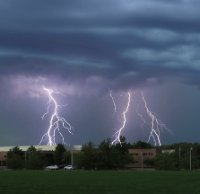
I remember the MCV coming through around 2 AM on the 22nd being incredible in terms of constant lightning bolts.
-
22 minutes ago, wisconsinwx said:
I agree it feels that way for me too. Besides 2010 and 2014, not any recent years stand out for garden variety storms, let alone severe, and what we do get tend to be very progressive. 2000-2010 was a lot more exciting for storms imo than 2011-2020 have been.
June 21-22 2010 was wild. I don't think I'll ever experience that again.
-
 1
1
-
-
27 minutes ago, ovweather said:
Most of my best lightning photographs came from smaller clusters of storms, although the MCS's do sometimes provide nice post-storm anvil crawler lightning, if the post stratiform rain shield moves out fast enough.
I guess the lack of CG's in storms the past several years intrigues me. I can fondly remember storms from 20 years ago that frequently produced intense cloud to ground lightning, with the subsequent ear-crushing thunderclaps that sent shivers down your spine.
Usually mature multicell clusters and concave-type structures produce good CG barrages. Bow echo's are often tilted back towards the stratiform region so a lot of the CGs land on the back side under the rain. It's often hard to find a lot of CGs out in front of a bow. QLCS type storm will produce lots of CGs in rain-free zone where there is a concave kink or curve to the line. The convex/bowing segments don't tend to have a lot of CGs out front. They tend to be on the back side instead.
Having a big anvil also seems to play a role too. Very new/isolated storms that haven't produced much of an anvil yet can be kind of lightning-sparce even when they have intense updrafts (even hail and such). I mean, they often do have a lot of lighting but it's usually predominately IC and not noticeable during the day.
-
1
-
-
19 hours ago, ovweather said:
Is it just a matter of my perspective or do thunderstorms as of late lack really good, intense lightning? Back in the 1990’s and early 2000’s I use to do a lot of lightning photography down here in the lower OV. Several times a week during the summer months I would head out to watch and photograph storms that rarely disappointed in terms of great lightning. Lots of dramatic CG’s and booming thunderclaps, and post storm anvil crawlers. Over the past 10+ years, I’ve only seen a handful of nice lightning producing storms, but even those lacked what I saw 15-25 years ago. Most storms of late have only had the occasional ho-hum in-cloud flashes, and if lucky, the occasional closer strike and ripping thunderclap. I miss the drama of intense lightning in storms. What gives?
I've seen a lot more IC activity compared to CGs. I think the big MCS with a large anvil and stratiform region produce more frequent CGs. Afternoon pop-up stuff doesn't always perform in terms of photogenic CGs, and that's what it's been this year. I think low cloud bases and heavy warm-process precip can be a problem for lightning photography. You often can't see the lighting until the storm is practically over you, then it's hard to photograph. If you don't get a strong MCS that produces lots of bolts-from-the-blue ahead of the rain shafts, the window for getting lighting is really brief. It's so much easier to film big bolts out west where you have high bases and much less precip. The Arizona monsoon can be amazing.
-
7 hours ago, WestMichigan said:
I'm closer to the lake than you so I am all too familiar with that shadow. Got 0.03" last night and that is it.
West Michigan seems to miss out on most general afternoon thunder. Hopefully Friday will feature a more organized MCS. Will really need the rain by then. Who knows if it will be evenly distributed though. So often it's a 40 mile wide E-W ribbon of 2-3" with almost nothing north or south.
-
2 hours ago, Chicago Storm said:
zzz
.At least Chicago doesn't get lake shadowed. This weak diurnal stuff always skips over my area. Storms make it 2/3 the way over the lake then die.
-
Hope the lake shadow pattern breaks at some point. It's annoying seeing thunder everywhere except the lee of Lake Michigan. Typical late June pattern.
-
1 hour ago, Kitchener poster said:
There is a T-storm to the SE of London that is almost stationary. A few unincorporated towns are probably getting quite the rainfall totals.
Lake breeze convergence.
-
6 hours ago, A-L-E-K said:
it's almost like lawns are bad
Keeping it green and short is pointless where I live. Everywhere is sand. Wild grass is very high from all the rain in May, but of course mowed grass is already going dormant.
-
14 hours ago, Kitchener poster said:
Unirrigated lawns are toast. Recent transplants are already seeing leaf drop.
No above average chances of rain until next Tuesday.
Sniffed this persistent dry down awhile ago.
It's weird seeing the current massive early torch go way up into Quebec where there was still 2+ feet of snow on the ground just two months ago. There's gonna be a boreal forest fire outbreak at some point if the warmth and drying continues.
-
1 hour ago, RyanDe680 said:
Decent pullback in the chances for storms this coming weekend.
Environment looks meh. Saturday looks like best bet
There is no EML.
-
On 6/10/2020 at 1:34 PM, Hoosier said:
Remember when the heat was supposed to help?
There are all kinds of variables at work of course. I have read that dry heat may spread it better than a humid airmass.
I wonder how much time spent in re-circulating AC air contributes to spread. I the north people open their windows and get fresh air. Arizona and Texas mid-summer is the other cabin fever season. Similar for Florida with the humidity if you're not right on the beach where you might be able to catch a breeze.
-
3
-
-
10 minutes ago, Maxim said:
The cold/trough talk is pure lol. Still running at a +4 departure for the month despite the recent cooldown.
In modern times a cutoff trough doesn't necessarily mean colder than average, but it usually means boring with no good ring-of-fire pattern ever setting up. Just seems like a lot of the good t-storm season has been wasted with blocky patterns this year. Last year was decent in May, July, and then again September, but I remember 2018 being boring for almost the entire summer... until late August. 2018 was warm but had a lot of cutoffs/blocks and was quite boring.
-
 2
2
-
-
1 hour ago, Hoosier said:
We are gradually descending toward La Nina. Nino to Nina transitions have generally had warmer than average summers, especially in the past 30-40 years. I wouldn't guarantee it but I'd definitely lean that way.
Seems like even most of the warm summers lately have been weird "warm with a SE trough"... i.e. slow block-y pattern with hardly any good storms outside the upper plains. Need some kind of broad westerly component in the 800-500 mb level to get the elevated mixed layer moving east into the Great Lakes and Ohio Valley. These meandering patterns with frequent cutoffs are always boring, whether they are warmer or cooler than average.
-
1
-
-
6 hours ago, CheeselandSkies said:
Not amplified in the right places though if you like spring for storms.
Less amplified is better for storms. This blocking nonsense is boring as hell. You'd think it would be over it by now since most of the latter half of May was a stupid SE-CONUS block. Nope. It's back already, and will only be broken down by yet another troughing pattern. I thought this summer was supposed to be warm. Wrong.
-
1
-
-
24 minutes ago, NTXYankee said:
lol eventually a line of storms won’t split or die when it moves into Columbus only to fill back in to the east.
Splits seem to happen because the outflow gets too far out ahead of the storm. Today I got some good time-lapse of a big whale-mouth shelf. It was so dark I thought for sure I was going to get clobbered, but when the shelf actually passed over the line was a bit broken with a lot of dry gaps between small cells. I think the shear was directed too much along the line, rather than perpendicular. I noticed the section that pivoted to the northeast (due to earlier MCV development) was more severe than the east-facing section. Orientation of the line relative to the shear seems to make a huge difference with the strength of linear segments. Supercells can do well with any outflow boundary orientation, so long as they aren't too crowded. Linear segments crap out and split pretty easy when the orientation is wrong.
-
4 hours ago, RogueWaves said:
Thunder's been pretty minimal with these cells tho. Not to be a buzzkill. Certainly worthy of the severe warnings but winds/hail are the bigger story it seems.
Most high-shear events produce a lot of IC lighting with the discrete cells. During the day you hardly notice the lighting. The bigger linear segments often have tons of CGs, but they can be hard to see in the rain. I really love storms that produce the big clear-air bolts out in front of the rain shaft, but they can be kinda rare. You almost have to live in a place like Florida that gets the daily sea-breeze convergence storms to see CG shows consistently.
-
2
-
-
1 hour ago, Solidsting said:
yeah last night the cams went off. even had PDS TOR in my area i was very suprised. but i figured they would favor a more linear mode anyways just knowing how the weather up here is
It seems like the backed winds aloft were a problem most places. Only a hard right-mover could really begin to rotate, and it never really happened. There were lots of brief little couplets embedded in the convection, but they never really lasted long. In Michigan, good discrete supercell structure with tornado potential only really seems to happen with a warm front in the area or in response to some kind of outflow boundary / lake-breeze interaction. With such a strong low level winds and strongly mixed environment there wasn't much in the way of boundaries for storms to latch onto. They just moved with the flow, more north than east, which wasn't really ideal. I know it's happened in the past, but it just seems really hard to get the proper type of hodograph for widespread supercells in Michigan. Probably a good thing.
-
1
-
June 26-29 Severe Threat
in Lakes/Ohio Valley
Posted
I'm wondering if the convection won't be surface based up here in Michigan. It will be a warm day, but rather dry. The higher dewpoints come in from the west over the lake late in the day.