
frostfern
-
Posts
1,984 -
Joined
-
Last visited
Content Type
Profiles
Blogs
Forums
American Weather
Media Demo
Store
Gallery
Posts posted by frostfern
-
-
1 hour ago, King James said:
Second wave was always going to happen. Whether we assign it to natural causes or other things, it may be prudent for people to start considering the bigger picture regarding where this is going. Gardens, hens, protein, self defense, sources of heat, water supply, cash etc are all smart things to think about having on hand.
Only one option allows us to be wrong and that IMO is preparing for a collapse of society. If I am wrong, cool.
Anyway looking forward to these storms tonight!
If people were willing to fight a virus like they fight a war against an invading army things would be different. Worship of individualism and capitalism is the undoing of the US. Nice for the people who can afford to stock shit and hide in bunkers. People who've been living paycheck to paycheck will come for your ass regardless.
-
 5
5
-
-
Maybe if the moisture tongue over Iowa gets up here there will be good elevated after-dark boomers. It's just really hard to see anything surfaced based getting this far north now. Unless the 925 mb - 850 mb winds really crank behind the current crapvection complex.
-
Looks like a stratiform rain event up here. Clouds everywhere. Typical. Don't know what SPC was thinking putting the enhanced risk up here yesterday. Wouldn't be bothered if the long range wasn't so dry and uneventful. Rub it in and give me a weenie.
-
1
-
-
The downward trend in Michigan is over :(.
-
 1
1
-
-
28 minutes ago, wisconsinwx said:
With all this crapvection, the current storms along the WI/IL border may be the event lol. If we get missed south, the complaint thread may be used

I'll take non-severe if it has good lighting. I just don't want EVERYTHING to miss way to the south. Need the rain. I hate these E-W oriented setups where one row of counties gets trained while others get crap.
-
2
-
-
I'm wondering if the convection won't be surface based up here in Michigan. It will be a warm day, but rather dry. The higher dewpoints come in from the west over the lake late in the day.
-
17 hours ago, bowtie` said:
Do you think the people in Saskatchewan are saying, " Look an Illinois screamer!".
Illinois clipper-in-reverse-mode.
-
Hope this will be a good show.
-
42 minutes ago, Chicago Storm said:
It’s still there.
.For western zones maybe. It's hard to say how long it takes for the ridge to build east with the new east coast cutoff clogging things up. Backdoor easterly flow knocking down the ridge looks possible at times. Looks like a warm dry pattern, but intense heat confined to the plains for a while. I just hope Friday night delivers some rain here because after that things get real dry.
-
5 hours ago, CheeselandSkies said:
That's what we say about Iowa and Illinois. Except never chase in Iowa because then the tornadoes will be in Illinois, and vice versa.
It's all relative, but in mid-summer generally the farther west you go the better. This looks like a repeat of 2018, warm but blocky with no ring-of-fire setup until late August. Probably something to do with arctic warming. Stratiform tropical system will be the only drought buster for the lake shadow.
-
1
-
-
After Friday it's back to the boring blocky pattern.
-
1
-
-
2 minutes ago, wisconsinwx said:
The origins of those storms were in SC Wisconsin I believe and gave us the Eagle tornado the evening of the 21st. On the 18th there were two consecutive derechos that came through many of the same areas (we were only impacted by one here but it was still noteworthy).
It became a big MCV / QLCS while crossing Lake Michigan. Wisconsin always gets the peak severe, but sometimes the late night leftovers here in Michigan are still good. Most times the Wisconsin evening MCS just dies completely, then afternoon stuff pops way to the east the next day. Annoying aspect of summer climatology here. The severe stuff often survives through west Michigan though. It's just when there aren't severe setups with good shear and/or low-level-jet the lake shadow dominates.
-
Just now, wisconsinwx said:
Yep, the week of storm action starting June 18, 2010 (it was a Friday) through June 24 gave excitement for everyone in this forum I believe.
I remember the MCV coming through around 2 AM on the 22nd being incredible in terms of constant lightning bolts.
-
22 minutes ago, wisconsinwx said:
I agree it feels that way for me too. Besides 2010 and 2014, not any recent years stand out for garden variety storms, let alone severe, and what we do get tend to be very progressive. 2000-2010 was a lot more exciting for storms imo than 2011-2020 have been.
June 21-22 2010 was wild. I don't think I'll ever experience that again.
-
1
-
-
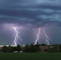
27 minutes ago, ovweather said:
Most of my best lightning photographs came from smaller clusters of storms, although the MCS's do sometimes provide nice post-storm anvil crawler lightning, if the post stratiform rain shield moves out fast enough.
I guess the lack of CG's in storms the past several years intrigues me. I can fondly remember storms from 20 years ago that frequently produced intense cloud to ground lightning, with the subsequent ear-crushing thunderclaps that sent shivers down your spine.
Usually mature multicell clusters and concave-type structures produce good CG barrages. Bow echo's are often tilted back towards the stratiform region so a lot of the CGs land on the back side under the rain. It's often hard to find a lot of CGs out in front of a bow. QLCS type storm will produce lots of CGs in rain-free zone where there is a concave kink or curve to the line. The convex/bowing segments don't tend to have a lot of CGs out front. They tend to be on the back side instead.
Having a big anvil also seems to play a role too. Very new/isolated storms that haven't produced much of an anvil yet can be kind of lightning-sparce even when they have intense updrafts (even hail and such). I mean, they often do have a lot of lighting but it's usually predominately IC and not noticeable during the day.
-
1
-
-
19 hours ago, ovweather said:
Is it just a matter of my perspective or do thunderstorms as of late lack really good, intense lightning? Back in the 1990’s and early 2000’s I use to do a lot of lightning photography down here in the lower OV. Several times a week during the summer months I would head out to watch and photograph storms that rarely disappointed in terms of great lightning. Lots of dramatic CG’s and booming thunderclaps, and post storm anvil crawlers. Over the past 10+ years, I’ve only seen a handful of nice lightning producing storms, but even those lacked what I saw 15-25 years ago. Most storms of late have only had the occasional ho-hum in-cloud flashes, and if lucky, the occasional closer strike and ripping thunderclap. I miss the drama of intense lightning in storms. What gives?
I've seen a lot more IC activity compared to CGs. I think the big MCS with a large anvil and stratiform region produce more frequent CGs. Afternoon pop-up stuff doesn't always perform in terms of photogenic CGs, and that's what it's been this year. I think low cloud bases and heavy warm-process precip can be a problem for lightning photography. You often can't see the lighting until the storm is practically over you, then it's hard to photograph. If you don't get a strong MCS that produces lots of bolts-from-the-blue ahead of the rain shafts, the window for getting lighting is really brief. It's so much easier to film big bolts out west where you have high bases and much less precip. The Arizona monsoon can be amazing.
-
7 hours ago, WestMichigan said:
I'm closer to the lake than you so I am all too familiar with that shadow. Got 0.03" last night and that is it.
West Michigan seems to miss out on most general afternoon thunder. Hopefully Friday will feature a more organized MCS. Will really need the rain by then. Who knows if it will be evenly distributed though. So often it's a 40 mile wide E-W ribbon of 2-3" with almost nothing north or south.
-
2 hours ago, Chicago Storm said:
zzz
.At least Chicago doesn't get lake shadowed. This weak diurnal stuff always skips over my area. Storms make it 2/3 the way over the lake then die.
-
Hope the lake shadow pattern breaks at some point. It's annoying seeing thunder everywhere except the lee of Lake Michigan. Typical late June pattern.
-
1 hour ago, Kitchener poster said:
There is a T-storm to the SE of London that is almost stationary. A few unincorporated towns are probably getting quite the rainfall totals.
Lake breeze convergence.
-
6 hours ago, A-L-E-K said:
it's almost like lawns are bad
Keeping it green and short is pointless where I live. Everywhere is sand. Wild grass is very high from all the rain in May, but of course mowed grass is already going dormant.
-
14 hours ago, Kitchener poster said:
Unirrigated lawns are toast. Recent transplants are already seeing leaf drop.
No above average chances of rain until next Tuesday.
Sniffed this persistent dry down awhile ago.
It's weird seeing the current massive early torch go way up into Quebec where there was still 2+ feet of snow on the ground just two months ago. There's gonna be a boreal forest fire outbreak at some point if the warmth and drying continues.
-
1 hour ago, RyanDe680 said:
Decent pullback in the chances for storms this coming weekend.
Environment looks meh. Saturday looks like best bet
There is no EML.
-
On 6/10/2020 at 1:34 PM, Hoosier said:
Remember when the heat was supposed to help?
There are all kinds of variables at work of course. I have read that dry heat may spread it better than a humid airmass.
I wonder how much time spent in re-circulating AC air contributes to spread. I the north people open their windows and get fresh air. Arizona and Texas mid-summer is the other cabin fever season. Similar for Florida with the humidity if you're not right on the beach where you might be able to catch a breeze.
-
3
-
Coronavirus
in Lakes/Ohio Valley
Posted
Could also load up on Lysol. Take a long ass needle and inject it into the lungs as a preventive measure.