

weathafella
-
Posts
47,920 -
Joined
-
Last visited
Content Type
Profiles
Blogs
Forums
American Weather
Media Demo
Store
Gallery
Posts posted by weathafella
-
-
I had to return a sweater I bought for someone today. The lady asked if I was prepared for the big storm-she sounded weenieish. I told her not to count on it and she started to argue with me. I just told her to try to remember who told her first. She said well you remember me when it happens!
-
 2
2
-
 5
5
-
-
Just now, NoCORH4L said:
Messenger shuffle, but backwards?
Actually the messenger shuffle typically ends with a few ticks back north at the last minute.
-
2
-
-
While it certainly doesn’t feel it the sky has the snow look fwiw.
-
1
-
-
1 minute ago, 78Blizzard said:
I think we will see a north movement from now to go time. How much, we will see?
I agree actually. Since my daughter’s SO is a Boston teacher he’s off tomorrow. At the very least I want him to come over and help with snow removal!
-
I can’t help but find this whole psychodrama dark comedy. Keep it coming!
-
3
-
1
-
-
It’s kind of funny to watch though. Ratters rat start to finish it seems.
-
2
-
-
-
Euro basically gives a non dynamic pos. Warm temps well into NNE.
-
3 minutes ago, CoastalWx said:
I think it will take most of the morning to dip below 32 even for you. Get ready for paste.
May get to see truly what the Ariens is made of…lol.
-
Just now, CoastalWx said:
Definitely an outage risk if it pounds at 33F with increasing winds.
Yeah I'm hoping to be AOB 30 but initially it will be mondo paste.
-
1 minute ago, STILL N OF PIKE said:
Navy model
-
1
-
-
Classic weather breeder today.
-
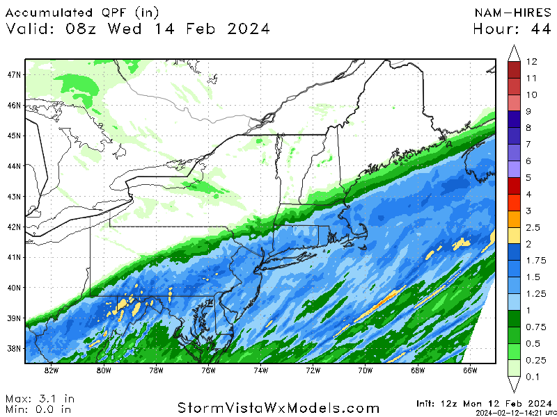
1 minute ago, Typhoon Tip said:
Ha! I know you guys don't normally look at the FOUS ( it's an old habit of mine ...) but my god at the QPF at Logan comparing prior runs.
since 12z yesterday's NAM ...every mode cycle only put out 2 intervals of QPF/liq equiv, and the numbers are always .5"-ish then .3"-ish ... totally ~ .8". It just was not changing for that location.
12z just now? .27" + 1.04" + .22" hahaha my goodness
Also cools the boundary layer for a big time snow thump by 12Z tomorrow.
OUTPUT FROM NAM 12Z FEB 12 24
TTPTTR1R2R3 VVVLI PSDDFF HHT1T3T5
BOS//732918 00015 133310 37000098
06000622928 -2115 112702 38039898
12000644233 00417 112802 39049898
18000736624 -1015 080410 40029698
24027989153 09317 020621 41009696
30104978929 04420 950228 34009592
36022824610 -2016 023115 25009587
42000594310 -1217 063016 20999488
48000766206 03312 072717 18989487
54000513207 -3314 103021 14999285
60000503308 00216 132921 15969086
-
1
-
-
-
-
Regardless of the qpf output, H7 on the Euro skirts along the southern new england coast which argues a much better system into NH despite what the qpf maps say. In fact the mid level centers have me feeling pretty good here in the pike region.
-
3
-
-
Ironically the gfs has been pretty stable with small changes following trends.
-
Today was the messenger shuffle day. Tomorrow likely will feature a tick or 2 back north. Not much difference either way from my perspective.
-
2
-
-
1 minute ago, moneypitmike said:
on way back to mass......on my phone so all I can hear is things are south, precip south, south coast and CT getting slammed......sounds like a SOP.
Hoping that's not what it is. For my sake that is.
You’re in great shape in westborough!
-
5 minutes ago, moneypitmike said:
If the gfs shifts south and sucks again on amounts I’ll really be bummed.
Presuming you’re in pit2?
-
-
1 minute ago, Ginx snewx said:
Yea I haven't used 12k for a while. Sorry thought you were referring to 3K cuz that's nutz here
3k annihilates most of MA late morning into the afternoon Tuesday.
-
Yeah 3k is a big time crusher.
-
Yeah actually snows pretty good Tuesday afternoon but it's not 8-12 job....lol.

Following a Miller A/B hybrid type coastal potential, Feb 13th ... As yet untapped potential and a higher ceiling with this one
in New England
Posted
I just remember all these systems slipping SE but making a correction at the last minute. Maybe I’m misremembering…