

Radders
-
Posts
801 -
Joined
-
Last visited
Content Type
Profiles
Blogs
Forums
American Weather
Media Demo
Store
Gallery
Posts posted by Radders
-
-
19 minutes ago, wdrag said:
First tenth of an inch in Wantage as sleet has changed to snow. Pavement getting slimy and very slippery on wood. 34F. ground white.
Very similar readings just west of you in Milford PA.
-
 1
1
-
-
4 minutes ago, bluewave said:
Numerous new highest low temperatures for the month of July across the region.
Time Series Summary for NEWARK LIBERTY INTL AP, NJ - Month of Jul
Click column heading to sort ascending, click again to sort descending.RankYearLowest Min TemperatureMissing Count1 2020 67 1 2 2019 66 0 - 1994 66 0 - 1993 66 0 Time Series Summary for WESTCHESTER CO AP, NY - Month of Jul
Click column heading to sort ascending, click again to sort descending.RankYearLowest Min TemperatureMissing Count1 2020 63 1 2 2019 61 0 - 2012 61 0 Time Series Summary for NY CITY CENTRAL PARK, NY - Month of Jul
Click column heading to sort ascending, click again to sort descending.RankYearLowest Min TemperatureMissing Count1 2020 67 1 2 2008 66 0
Time Series Summary for LAGUARDIA AIRPORT, NY - Month of Jul
Click column heading to sort ascending, click again to sort descending.RankYearLowest Min TemperatureMissing Count1 2020 68 1 - 2008 68 0 2 2019 67 0 - 1994 67 0 Time Series Summary for JFK INTERNATIONAL AIRPORT, NY - Month of Jul
Click column heading to sort ascending, click again to sort descending.RankYearLowest Min TemperatureMissing Count1 2016 66 0 2 2020 65 1 - 2019 65 0 - 2015 65 0 - 1970 65 0 Time Series Summary for FARMINGDALE REPUBLIC AP, NY - Month of Jul
Click column heading to sort ascending, click again to sort descending.RankYearLowest Min TemperatureMissing Count1 2020 67 1 2 2019 64 0 Time Series Summary for ISLIP-LI MACARTHUR AP, NY - Month of Jul
Click column heading to sort ascending, click again to sort descending.RankYearLowest Min TemperatureMissing Count1 2019 64 0 2 2020 63 1 - 1994 63 0 Time Series Summary for IGOR I SIKORSKY MEMORIAL AIRPORT, CT - Month of Jul
Click column heading to sort ascending, click again to sort descending.RankYearLowest Min TemperatureMissing Count1 2020 64 1 - 2019 64 0 - 1994 64 0 Time Series Summary for MONTGOMERY ORANGE COUNTY AP, NY - Month of Jul
Click column heading to sort ascending, click again to sort descending.RankYearLowest Min TemperatureMissing Count1 2020 57 2 2 2019 54 1 - 2013 54 0 - 2012 54 9 Time Series Summary for New Brunswick Area, NJ (ThreadEx) - Month of Jul
Click column heading to sort ascending, click again to sort descending.RankYearLowest Min TemperatureMissing Count1 2020 63 0 2 2019 60 0 - 1931 60 0 - 1897 60 0 Time Series Summary for SUSSEX AIRPORT, NJ - Month of Jul
Click column heading to sort ascending, click again to sort descending.RankYearLowest Min TemperatureMissing Count1 2020 58 1 2 2019 54 0 Time Series Summary for PHILADELPHIA INTL AP, PA - Month of Jul
Click column heading to sort ascending, click again to sort descending.RankYearLowest Min TemperatureMissing Count1 2020 67 1 2 2011 66 0 - 1994 66 0 - 1993 66 0 Those rural airport (Sussex and Orange) lowest minimums are impressive.
-
 2
2
-
-
Looks like the park hit 90 between the hourly obs. Currently 87/72
-
10 minutes ago, psv88 said:
Anyone who believed the 86 degree dewpoints hasnt been at this long.
Yeah - unlikely, but could see the usual coastal spots like KJFK beating the guidance by a couple of degrees.
-
2 minutes ago, IrishRob17 said:
Is it showing any of those mid 80s dews it had the other day? I haven’t had a chance to look yet.
Looking at the smoothed out SV images, it looks like it has backed off on the expansiveness of 80+ DPs a little, but still showing pockets of the 80s shade. Seems like high 70s DPs area wide are becoming increasingly likely..
-
1 minute ago, Gravity Wave said:
The 6z GFS is a lot less aggressive with dews, low to mid 70s across the area. The 6z also cuts the worst heat off after Saturday, I'm interested to see if that becomes a trend or if its just a blip.
I have been looking at DP forecasts over the last week or so and have noticed that the GFS in general seems to go less aggressive vs. the Euro. Is this a known GFS or Euro bias?
-
Light snow changing to heavy snow with huge flakes within two minutes with 2/10 tenths of a mile visibility on I87 from Suffern on east in Rockland. Roads are covered. So much for this thing starting late afternoon/evening.
I can see the sun here!!! lol
-
I had a bad feeling about getting screwed on this storm even though i called for 6" - I think i could bust here and it might never get further north than southern Putnam. We will see.
It just amazes me that the same areas of NJ are getting hit again and again... What a winter for them down there.. At some point, this pattern HAS to change to something more climatologically normal.. These sharp cut-offs are really miserable when you are on the wrong side of them.. We are doing much better than last year at this point, but I really feel for the folks in PA who just can't catch a break.
-
Here is my best guess for this upcoming storm as far as accumulations go for E NYS. I also included an educated hypothesis for 5 selected cities from the Upper HV down to NYC. May or may not update this pending 0z runs Tonight...
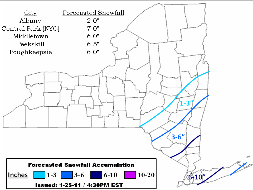
Thanks for the input... This looks very reasonable based on where things stand.. I am personally thinking 6" is a good forecast for the SE areas of the NWS Albany forecast area.
-

We still have a shot, we are real close to cashing in. Dr No in a few minutes....

Euro says no, this new season is not coming this fall.
-
I would say about 3" here.. Anxiously awaiting the Euro... i am feeling FRINGED!!! lol
-
Just got back from driving to KSWF to drop a friend off for a flight... What a disaster an unexpected 2 inches can have on the roads - A few spin-outs on I84.
~2 inches here and still snowing light to moderate.
Considering we may get shafted with the best stuff to our south tomorrow, I will take it!
-
Radders where are you...lol I hear the Euro is a thing of beauty for the area.. >1.5" of qpf... Can you confirm?
Better late than never ,but yes, I can confirm this..
-12F here.
-
9* here.. Apparently there is a wind shift boundary running down the Hudson.. Once the boundary moves through (next hour or so), and the wind switches from NW to NE, then the temps will start to drop quickly.
-
I see what ya did there

 My brain is clearly not working properly this morning!
 -
Yea I hear you. Heavy QPF sounds like mixing may be an issue. No mixing then light QPF. What do you make of the 12Z NAM?
NAM looks like it might hit us lightly to moderately, but I just can't look at that model with any seriousness beyond like 60 hours!! The GFS looked better than it's 6Z run, but the energy swinging across the great lakes is still pushing the trajectory to our east too much.
Right now, I am kind of taking the op runs with a pinch of salt and hugging the ensembles... With this many options on the table, and this much complexity, the ens are the only way to try and make sense of this IMO.
-
I don't know exactly what I got down to last night but the local high school made it to 3*. When I drove by there last night on the way home it was 10 and when I got home it was 6 so "extrapolated" I'm guessing I got to about -1

So, what's the current thinking for Wednesday? I like the map DT put up that has the lower HV in 12+

I really don't know what to think about Wednesday's event... I think we see some snow, but I have a feeling that we are going to get fringed.. I like the Euro and it's ensembles last night, but I don't know if I buy it yet.. I will be watching the 12Z guidance closely.
-
I think it got to -8 at the airport (KPOU), haven't checked what my weather station got down to yet, but currently it shows -2F right now
-
<br /><br /><br /><br />Anybody else have a fresh coating of snow hiding the black ice this morning? Should be a fun ride...<br />Yes. Nasty drive to the train station this morning.
-
Hangin' tough at 21*
Trees are starting to get glazed now so I'm assuming it's mixed sleet and freezing rain. My wifes boss told her that if she doesn't make it in by 10 yesterday was her last day at that job  but that he would be working from home. I think I may have to head to his house and "explain" to him how rotten his attitude is
That is awful..

-
Well i have 2.5 inches of snow/sleet/ice since this event started... Perhaps I make it to 3, but overall, not a very overwhelming event. 24F IMBY.
-
-2.5 IMBY this morning...
-4 at KPOU
-
Heat wave here 9.1. Forcast low is 8, think I'll beat that soon.
 have you beaten it yet? 6.5 here.
 -
Already down to 9F! Could get really cold tonight before the clouds from the clipper move in...
December 16-17, 2020 Storm Observations and Nowcast
in New York City Metro
Posted
21.7/5 in Milford PA