

WEATHER53
-
Posts
7,787 -
Joined
-
Last visited
Content Type
Profiles
Blogs
Forums
American Weather
Media Demo
Store
Gallery
Posts posted by WEATHER53
-
-
Forecasters catching on now. Models mean zip. Look at the radar and other tools. Already a solid east to west movement of rain down the coast .
This won’t be missing DC to the east.
Sat: Rain developing late .
Sat night:Rain , , heavy at times with ne winds increasing 20-30mph
Sunday : Rainy and raw with ne winds 20-30 mph, sustained 25-35mph possible, gusts to 40 and gusts to 50 possible, chilly highs 55-60
Monday: Rainy ending in afternoon and windy, DC area rainfall 1-3”
Little change in my forecast since Monday
-
 2
2
-
 1
1
-
-
42 for a low and that’s coolest of season
-
Models won’t get this right. A lot of combined energies exploding right over the mid Atlantic region .
-
 1
1
-
-
1 hour ago, Eskimo Joe said:
Looks like 1" - 2.5" with 15 - 25 mph winds is on the table. Boom potential is 2" - 4" rain, with 30+mph wind. Bust is less than 0.5" and a slight breeze.
I think winds may go sustained 25-30 gusting to 40. Be fun to get hit but not hurt
-
1
-
-
3 hours ago, stormy said:
46 years ago tonight, October 9, 1979, Augusta received 9 inches of snow!!!!!!!
Trees broke up like a cat. 2 hurricane from the weight of the snow on leaf covered limbs!!!
70 degrees the day before.
34.1 this morning, going to freezing tonight!!
I was on my balcony in Beltsville and watched it change to snow. Had to overcome a lot but got 0.5” and that’s earliest ever.
-
2
-
-
64.5 for the high which was coolest max of season. I’m going to be in 40’s by midnight and that has not happened this season
-
My latest update on this is it continues to increase in intensity
By very late Saturday night or wee hours of Sunday it gets going. Winds pick up to 20-30 from e-ne and temps hold in 50’s Sunday with squally rains and winds 25-35 gusting to 50 before ending around dawn Monday with 1-3” of rain and strong ne winds all day Monday.
Should I create a new thread “The 53 storm discussion and obs” ?
-
 1
1
-
 1
1
-
 1
1
-
-
Get ready for this one
20-30 sustained with gusts to 40 and 1-3” around DC . Stars mid to late Sat and may not end until Monday morning
-
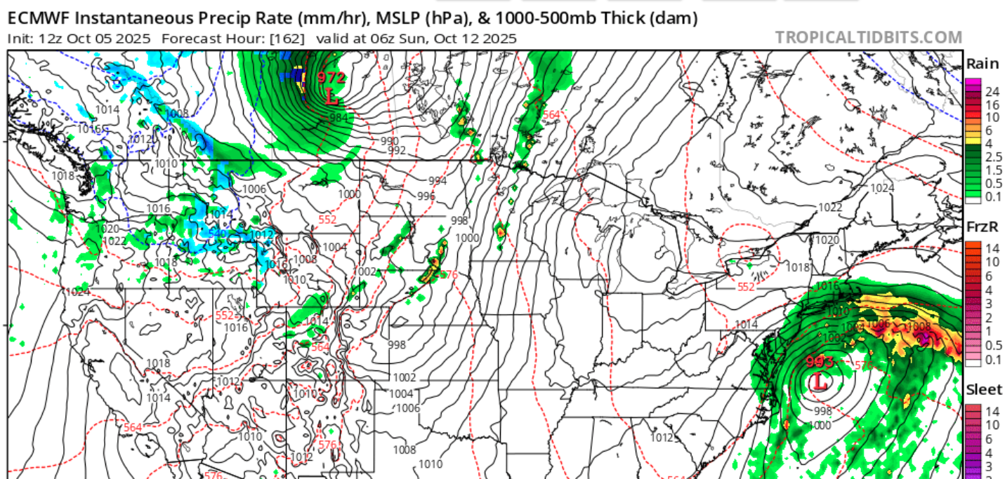
7 minutes ago, Paleocene said:
Euro from Sunday 12z

There was no text forecasting nor model support for mid Atlantic storminess MTW of this week and I issued my statement on Monday. What one model said for one run on Sunday dont mean shit and even that was just showery.and east of DC
We have self appointed hall monitors here in the winter and don’t need that year round. Sorry for you that getting it right irks you
-
On 10/6/2025 at 6:50 PM, WEATHER53 said:
Maine set some high temp records today .
This system for the weekend looks potent for DC
The system is now being forecasted as potent despite a pissy hissy in another thread
-
6 minutes ago, high risk said:
That isn't even remotely true.
Bullshit
-
 1
1
-
-
3 minutes ago, high risk said:
That isn't even remotely true.
You best be sure before you say someone is lying chump. On Monday I mentioned the storminess and had several discredits of it and it’s really only today that models have started showing storminess with NWS first introducing chance if showers last night. You need to keep your irksome of my early and good observation to yourself
-
1
-
-
19 hours ago, WEATHER53 said:
NWS finally working some rain in for late Sat and look for this pending event to receive more attention very soon
48.3 for my low and models now picking up on storminess I referenced back on 10/6.
-
18 minutes ago, dailylurker said:
The GFS made a big jump west and crushes the entire area with heavy rain and storm force winds on the bay. I figured we can talk about the storm here since it's no longer long range. LFG!
This is what I was on to days ago in the October thread and the models had nothing about it until now.
I still expect 20-30 sustained gusting to 40 and 1-3 around DC-
1
-
-
On 10/6/2025 at 6:50 PM, WEATHER53 said:
Maine set some high temp records today .
This system for the weekend looks potent for DC
NWS finally working some rain in for late Sat and look for this pending event to receive more attention very soon
-
1
-
-
10 hours ago, Roger Smith said:
I think the correct answers were 4/3/2. Season is now 10/4/3 so it was a boost to a rather anemic count by modern standards, fairly average for all data though.
Could see the final count being 13/6/3 or 14/6/3, very close to 1991-2020 average, by no means a blockbuster season, and a lot of tracks staying out to sea. The only people sad about that are probably reading this.
")
I went 7/4/2 so graded F/C+/A
-
3 hours ago, JenkinsJinkies said:

Not gone yet .
Wild pressure gradient develops
-
Maine set some high temp records today .
This system for the weekend looks potent for DC
-
1 hour ago, Terpeast said:
I’d say in general, we don’t want a cold october as that tends to correlate with milder winters. So if a -NAO causes a colder october in the east, we probably will want to root against it.
I also find a reverse correlation in Oct but it’s for the first half and for temps
-
1
-
-
Many times in the mid Atlantic we get our first tropucal influence about 5 days after the first real cool shot moves out. The first cool one is over us right now and I’m curious to see what happens next
-
1
-
-
10 hours ago, Coach McGuirk said:
But everything is out to sea.
Quit whining like a child
-
1
-
-
2 hours ago, MJO812 said:
Another season where many forecasters had the east coast above average chance with alot of storms. Just like winter outlooks, take the tropical outlooks with a grain of salt or maybe not do outlooks way far in advance.
I’m wondering if the generally far better tropical forecasts have now fallen victim to the winter storms micro management that just does not work
-
2
-
-
32,33 34 came up but so long ago I just leave it alone.
-
On 9/15/2025 at 6:51 AM, stormy said:
Sometimes fall patterns can be harbingers for the coming winter.
1977 is an excellent example.
Low pressure over eastern NC. tomorrow with chilly high pressure wedging down from New England....................... Can this become a habit as we slide into winter????
Very much agree. Be nice to see today’s radar later on.

The return of the elusive Nor'easter. Drought buster or bust?
in Mid Atlantic
Posted
Rain mass is west of Ricky Mount and still moving wnw and that’s a historical reference to me for rain mass making it thoroughly over DC