

Ottawa Blizzard
-
Posts
4,530 -
Joined
-
Last visited
Content Type
Profiles
Blogs
Forums
American Weather
Media Demo
Store
Gallery
Posts posted by Ottawa Blizzard
-
-
On 12/5/2020 at 1:19 PM, BuffaloWeather said:
History repeats itself. I think we can learn from the 1918-1919 pandemic. There were 3 discreet waves. They had no vaccines during that time. We are currently in the middle of wave 3. The only part here is that wave 3 is going to hit the hardest, whereas in 1918-1919 wave 2 hit the hardest. That most likely has to do with timeframe. Wave 2 back then hit where wave 3 is hitting today. (October-December) Based on the CDCS data of 1 in 8 confirmed infections being undetected. 15 million*8= 120 million people have had Covid 19 already. Herd immunity is closer than we think.

That's interesting. Up here in Canada, they are calling what we are in now the second wave, and it is correlating almost exactly with the second wave of the Spanish Flu pandemic.
-
1 hour ago, dan11295 said:
Ugh @ California
24,000 cases, including 8700 in LA County
Wow, that's crazy. I wonder why it's so bad in California?
-
1 hour ago, WaryWarren said:
Joe "Climate Change Isn't Real" Bastardi is a dope when it comes to COVID too? Say it ain't so.
I honestly used to try and defend him on this board, but lately he has become absolutely ridiculous. He was good up to about 10 years ago, became terrible once he left accuweather.
-
 1
1
-
-
1 hour ago, Baum said:
I'll take the next 4 winters after 1975.
January 1976 apparently wasn't too bad either.
-
1
-
-
7 hours ago, Snowstorms said:
Without diving into too much detail, both the GEFS and EPS offer some hope after Dec 10th. The current +PNA retrogrades into the EPO region and that offers up our first legitimate cold shot of the season ~Dec 12-14. Would likely feature a rainer around that time frame before things settle into a wintrier pattern thereafter. Eventually due to the background Nina forcing, the ridge makes its way towards the Aleutians/AK which cools most of Canada down as the PV sits overtop. In other words, the current Nino like pattern eventually gives way to a more typical Nina like December around mid-month. There is also increasing chances for Arctic blocking around mid-December as well. I’d say our first winter storm will be ~Dec 15 to Dec 20.
It's interesting how similar this Fall season has been to that of 1975, another La Nina year, in some ways. Very warm first half of November, cooler conditions late November. There was a big storm in Toronto around December 20th, 1975, according to Environment Canada data.
-
1
-
-
6 hours ago, Snowstorms said:
It is possible if we get a phased storm. Though we haven't seen a true phased storm in years. I believe 2013-14 featured some spread the wealth type events. Only other possibility is having an active storm track where everyone gets a piece of the pie, albeit in different storms.
There was a storm in late January 2004 that gave almost a foot of snow to Toronto, and also to NYC. Not very common, I would think.
-
1
-
-
Just now, Hoosier said:
My fear is that we time it where the back half of Dec is worse than the first half. Hopefully not, because warm holidays suck.
Best Christmas/holiday weather period of the past decade was that of 2017, in my opinion.
-
1
-
-
1 minute ago, rochesterdave said:
If only there was some cold air. The 850’s and 700’s are so close. It’s wild watching the surface LP placement from run to run. They are jumping around by hundreds of miles. Makes a big difference for Erie, CLE and Toronto.
I'm expecting mostly cold rain out of this in Toronto. Is there any model saying anything differently?
-
That does look terrible. I was thinking maybe this winter would be like that of 1975-76? That was a La Nina that saw a very warm first two weeks of November.
-
2 hours ago, Snowstorms said:
Strong lake effect snow band about to move into Toronto. Up to 2” possible and near zero visibility.
Yup, we got hit hard out my way. Near zero visibility around 7 PM.
-
11 minutes ago, snowstormcanuck said:
Lived almost my entire life in Toronto and we've never been under a blizzard warning
 .
.
So, you're looking at 2.5-3 feet of snow basically. Photos would be swell!
I think Toronto came close prior to the Groundhog day storm in 2011.
January 2-3, 1999 was also classed as a blizzard, I believe.
I would love to have experienced the January 1966 storm.
-
7 hours ago, Snowstorms said:
Around 6” at YYZ with reports of 5-8” across the GTA.
Potential for some lake effect snow later today and tomorrow across the GTA. Localized amounts of 2-6” possible.
Wondering if that big squall is going to pass through Toronto early Friday afternoon?
-
1 minute ago, snowstormcanuck said:
I think that's a lock but it's going to be more of a gradual process.
Do you think we'll get impacted by the squalls on Thursday and Friday?
-
2 minutes ago, snowstormcanuck said:
It's been tough to get visibilities below 1SM. Was hoping for a little rippage.
We'll see what happens overnight. My 6-8" call might still be good.
-
48 minutes ago, BuffaloWeather said:
Has been pouring rain all night

An unusual set-up for sure. It's snowing steadily here in Toronto. Hope you guys change over soon!
-
1
-
-
42 minutes ago, snowstormcanuck said:
lol
Heavier snow seems to have moved in...
-
5 minutes ago, Snowstorms said:
Radars look unimpressive. Looks like a dry slot towards Oakville and Hamilton.
Latest HRRR has a sharp cut-off across the GTA. Hoping we see some good returns as the storm begins to deepen and retrograde. Column has cooled so ratios should be close to 10:1. Some people are calling it a “bust” on Twitter lol.
I'm starting to think bust too. Not as impressive as I was expecting, unless heavy snow movies in late tonight and overnight.
-
4 minutes ago, snowstormcanuck said:
23z HRRR showing 6.7" additional. Last check, YYZ was up to 2.8" (2.8 + 6.7 = 9.5", which is definitely towards the high end of expectations, unless anyone believed the few clown RAP/GFS runs showing 12"+) .
We would need to start cranking though at some point. Cloud tops starting to cool and pivot N/NNW across E OH/W PA. Hopefully that's a good sign.
Here's hoping. I was a bit concerned earlier today when the snow didn't seem to be sticking.
-
14 minutes ago, snowstormcanuck said:
That was a much more impressive storm though:

Wow, you can't get a more perfect track for Toronto and Buffalo than that February 1984 storm!
-
4 hours ago, Snowstorms said:
Latest HRRR has ~8” in Toronto by 6z Thurs and still snowing. Heaviest amounts centred from Hamilton to Oshawa including Toronto.
Feeling more confident with 6-10”.
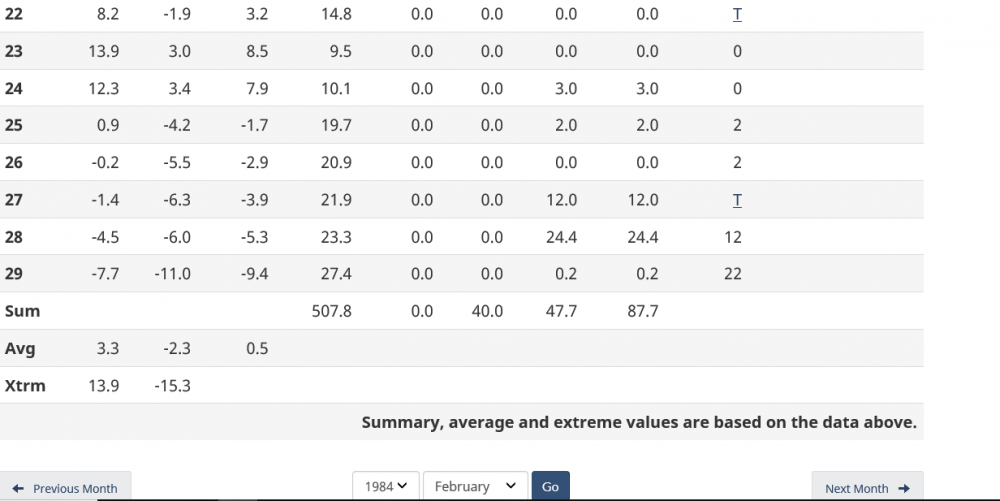
Late February 1984 in Toronto. Some similarities. Temperatures in the low 50s Fahrenheit on the 23rd-24th, followed by 36. 4 cm (14-15") of snow on 27th-28th, followed by temperatures in the 20s to end the month.

-
2
-
-
Late February 1984 in Toronto. Some similarities. 36 .4 cm (14-15" ) of snow on the 27th-28th, just days after temperatures in the low 50s on the 23-24th. Storm was followed by highs in the low 20s.
-
2
-
-
2 hours ago, snowstormcanuck said:
I'll finalize my 4-8" but up I could see us going north of 8" if things break right.
I'm going with 6-8"
-
1
-
-
33 minutes ago, Snowstorms said:
Nice to see a WNY and ON special for once.
I'm telling you it's like what I've read about the great leap year storm of February 1984. Not sure if anyone here is old enough to remember it - I was 3 going on 4.
-
9 hours ago, DeltaT13 said:
Agree, but even dividing those numbers by 5 (which is similar to what you're eluding to) still yields a statistically significant "snowstorm" for Toronto. I'm happy to see them at least have a shot.
Toronto is an unbelievably snowless location for its latitude and proximity to the great lakes (which obviously don't help them). Look at these pitiful numbers...
If they even got 7 inches it would be their largest single day snowfall in over a decade, AMAZING
Most snow to fall in one day during recent years in Toronto
Inches Date
3.5 November 15, 2018
6.1 February 12, 2017
5.4 December 11, 2016
4.1 February 21, 2015
6.9 December 11, 2014
4.1 December 14, 2013
5.0 February 02, 2012
2.5 February 26, 2011
5.3 January 28, 2010
What about February 7, 2013. I could have sworn we saw over a foot with that storm.


Winter 2020-21 Medium/Long Range Discussion
in Lakes/Ohio Valley
Posted
Does anyone know if the winter of 1931-32 was a La Nina?