

Ottawa Blizzard
-
Posts
4,530 -
Joined
-
Last visited
Content Type
Profiles
Blogs
Forums
American Weather
Media Demo
Store
Gallery
Posts posted by Ottawa Blizzard
-
-
10 hours ago, donsutherland1 said:
Thanks Ottawa Blizzard. I hope all is well with you.
I'm not sure what The Weather Network and Weatherbell saw or on which they based their forecasts. The composite temperature anomalies for neutral-warm/borderline weak El Nino cases didn't favor widespread cold in Canada (northern Canada was favored), especially in Ontario. The C3S multi-system guidance also favored warmth across a large part of Canada. Toronto will likely wind up having a warmer than normal winter. Unfortunately, snowfall appears to be in line for a below normal season.
Hi Don, with regard to The Weather Network's forecast, please see the link below.
I think it goes without saying that their forecast is in trouble.
-
 1
1
-
-
9 hours ago, donsutherland1 said:
Thanks Ottawa Blizzard. I hope all is well with you.
I'm not sure what The Weather Network and Weatherbell saw or on which they based their forecasts. The composite temperature anomalies for neutral-warm/borderline weak El Nino cases didn't favor widespread cold in Canada (northern Canada was favored), especially in Ontario. The C3S multi-system guidance also favored warmth across a large part of Canada. Toronto will likely wind up having a warmer than normal winter. Unfortunately, snowfall appears to be in line for a below normal season.
I'm not sure about The Weather Network Don, but Weatherbell seems to have been basing their forecast on the warm water south of Alaska, and how this apparently led to cold in years like 2003, 2014, and 2015. However, it has to be said that, on his blog this morning, Joe Bastardi has drawn attention to the winter of 1936-1937, which apparently also had warm water in the Gulf of Alaska, but ended up with a warm winter in eastern North America, following a colder than average November. Here is a link to that winter's observations in Toronto.
-
1
-
-
11 hours ago, donsutherland1 said:
With regard to the Week 3 (January 10-17) Ridging in the East:
There is a wide range of thought concerning this potential ridging (the "missing piece" I alluded to yesterday on a GEFS map). Unfortunately, a day later, the EPS, GEFS, and Canadian ensembles have all "found" this piece.
That raises the question as to whether it is a realistic model depiction in a timeframe where skill scores are low.
I believe it is. This does not, of course, mean that I expect it to persist through much or all of the remainder of January. It's far too soon to make such a call. I do believe it is a crucial development that will likely lead to a warmer than normal month as a whole in much or all of the East (I'm currently thinking somewhere in the vicinity of 1.5° above normal but haven't finalized the number).
My reasoning concerning the development of the ridging is as follows:
1. The latest EPS (and GEFS) forecasts the MJO to move into Phase 5 toward January 10 (the start of the period in question).
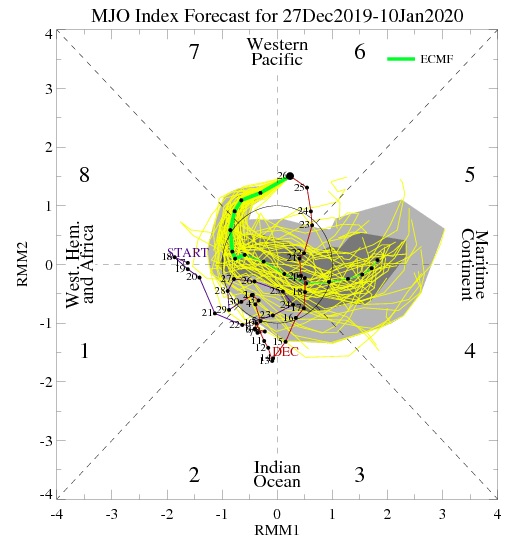
Model guidance has grown firmer on this idea in recent days, though such forecasts are still in a time range with low skill (and a wider turn that takes it through an alternative path that includes Phases 7-8-1 rather than 4-5 can't be ruled out). The fading IOD+ may also still be constructively interfering with the MJO. Rossby wave activity may also have an impact.
The 200 mb height anomaly (DJF with no lag) for Phase 5 produces a map that is quite similar to the forecast 500 mb anoamlies shown on the latest ensemble guidance (including the 6z GEFS) in the extended range:
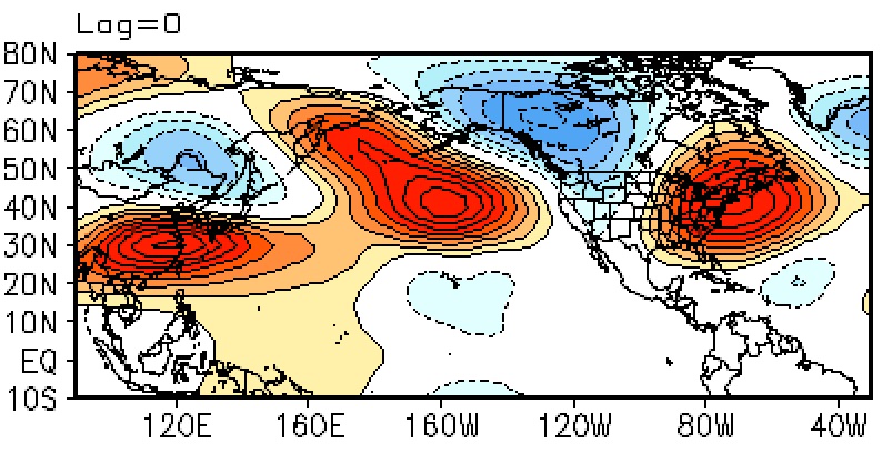
Any time one of the composite maps fits modeled output suggests one should give at least some consideration to that output.
2. The 12/27 0z EPS and 12/27 6z GEFS show the development of ridging in the East in the extended range (present from hour 336 and afterward on the EPS and from hour 354 and afterward on the GEFS). The CFSv2 week 3 forecast also shows such ridging.
3. The pattern fits the January 500 mb pattern with a monthly AO of +1.000 or above and an EPO > 0 (1950-2019).
4. The ensemble forecasts call for a strong polar vortex to be present through at least January 10.
5. No significant stratospheric warming events are likely through at least the middle of the first week of January according to the EPS.
Overall, there is a body of evidence that argues for ridging to develop in the East around January 10 +/- a few days. Whether such ridging persists will depend on the progression of the MJO (will it spend appreciable time in the Maritime Continent before progressing through Phases 6 and 7 and 8 should the EPS forecast verify?) and the state of the teleconnections (persistence of AO+/EPO+).
Some of the new guidance shows the EPO falling to neutral late in the first week of January or just afterward, so that's a positive development that will need to be watched. At the same time, some of the recent guidance shows the development of a PNA- in the extended range, a development that would also favor ridging in the East.
As always, it should be noted that such forecasts have low skill and may change considerably over a week or two. Moreover, I could be wrong. The main point was that there is a body of evidence to suggest that the forecast development of ridging is plausible. The picture should become clearer over the next week.
Great write-up Don. It's interesting that, up here in Canada, Environment Canada was the only outlet which called for a mild winter. It was against the grain, and raised eyebrows in other weather outlets; The Weather Network called for a much colder than average winter across much of Ontario. It's looking increasingly likely that Environment Canada and the NWS were right, while Canada's Weather Network and Weatherbell Analytics were wrong.
-
1
-
-
5 hours ago, BuffaloWeather said:


Ouch! Honestly, it's looking like Environment Canada and the NWS may be heading for victory with regard to their call for a warmer than average winter. They were against the grain and Environment Canada's forecast, in particular, raised some eyebrows up here in Canada from other weather outlets.
-
15 hours ago, Buffalo Bumble said:
How’s the snowpack doing up in Ottawa? I have some time off and was considering heading north to get in some cross country skiing. Certainly not happening around here for a while.
I have actually been living in Toronto for the past few years, so don't see as much snow as I used to up in Ottawa. That being said, last winter was pretty good, particularly late January and early February.
Currently bare ground in Toronto, although, if you can believe it, we have so far seen more snow this winter than we did throughout the entire winter of 2011/2012. November 2019 was the coldest November in Toronto since 1976, and in the top 5 coldest on record.
Was in Montreal last weekend and the difference in temperature compared to Toronto was impressive - about 13 degrees Celsius colder in fact - thanks to the northeasterly flow.
As for Ottawa, it looks like they're expecting a fair bit of snow this Sunday and Monday, so you should be good for skiing.
-
6 hours ago, BuffaloWeather said:
EPS shows cold sliding down under from Alaska.

Keep hearing different ideas of how January, and indeed the winter, will turn out. Up here in Canada, Environment Canada is calling for a mild winter ,while The Weather Network is calling for a cold winter. Ryan Maue is calling for a warm first half of January while JB is calling for a big flip to cold. Will be interesting to see how it all turns out. I hope this doesn't go the way of 2005-2006 - that winter was originally predicted to be cold only for January to be a torch.
-
I'm surprised arctic sea ice is so low when you consider how cold it has been in the Arctic.
Forecast for Resolute is below.
-
Good morning everybody,
Cold surprised me this morning with far lower values than expected in the territory:
Dawson -45.3C
Old Crow -43.9
Beaver Creek -43 (do not have the exact)
Carmacks -42.6
At my place -42.1C !
Here are some pictures I took this morning at sunrise, with some ice crystals fog


Just wanted to drop in and congratulate you guys in Alaska and the yukon who are having such an amazing winter. Has been largely a dud for us out east! Amazing pics by the way!
January 2020 Discussion
in Lakes/Ohio Valley
Posted
It's looking like the forecast put out by Canada's Weather Network could be in serious trouble.
https://www.theweathernetwork.com/ca/news/article/canadas-winter-forecast-update-2019-2020-winter-pattern-locks-in-for-january
Environment Canada's forecast looks to be on target, though.
https://weather.gc.ca/saisons/prob_e.html
Amazing how different the two forecasts are.