

jm1220
-
Posts
24,534 -
Joined
-
Last visited
Content Type
Profiles
Blogs
Forums
American Weather
Media Demo
Store
Gallery
Posts posted by jm1220
-
-
In Long Beach-looks like we get split screwed. Typical.
-
Surprised no heat advisory. JFK heat index hit 105 today.
-
 2
2
-
-
90. Officially another heatwave IMBY. And wow it feels like it.
-
2
-
-
High of 92 today.
-
1
-
-
High of 92. Heat’s definitely back.
-
1
-
-
2 hours ago, bluewave said:
Continuation of the same pattern into late June. Another weekend with chances for rain but no washout. Saturday looks like the best chance for scattered convection. Drier on Sunday. Then mid 90s on Monday just inland from sea breeze front west of NYC.
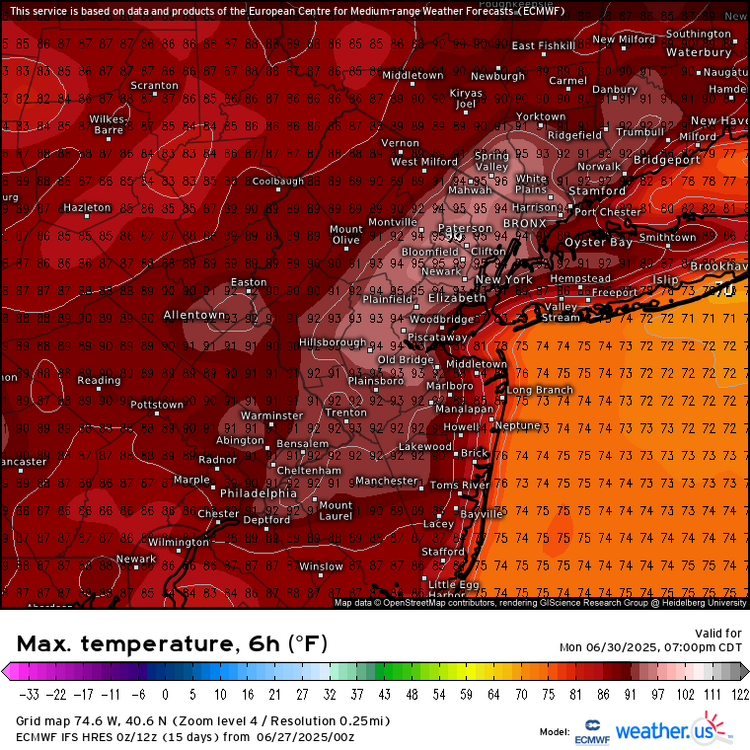
Looks like a general steam bath pattern. 92/75 is no fun here either.
-
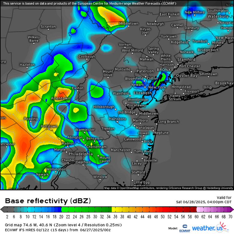
Pretty cool interaction between the outflow boundaries from earlier storms N of the city with the seabreeze firing more storms over LI. Also can see the backdoor coming into the twin forks which will probably fire more showers/storms.
-
-
1 minute ago, LibertyBell said:
Two days in a row JM!! Did you ever do that when you were in Long Beach??
Highly highly doubt it.
-
1
-
-
-
Looking at the Boston radar you can see tomorrow’s relief charging west.
-
1
-
-
-
6 minutes ago, Sundog said:
I've been stuck there for a few hours. Yesterday I had continued to rise and was also a couple degrees ahead of my current temp.
I don't know if we'll get much higher.
Yesterday I was at 99-100 then when the seabreeze came north I spiked to 103.
-
1
-
-
-
-
A few stations over 100 in southern Baldwin/Oceanside. Guess that’s the compressional heating area today.
-
1
-
-
Looks like an attempt at a seabreeze so far right near the Great South Bay and immediate barrier islands but not really cooling it off at all. 92/76 is hideous.
-
-
1 hour ago, Cfa said:
“In New York City, the temperature fell just shy of hitting triple digits, but the high of 99 degrees was still enough to beat the previous daily record for the date, surpassing the high of 96 degrees set on June 24, 1888. Some areas not far from Central Park, where the official weather observations for the city are taken, did manage to hit 100 degrees, including Newark (103) and John F. Kennedy International Airport (102).”
That’s a lot of unnecessary verbiage to contradict the first statement. JFK, LGA, JRB, and the entire micronet just don’t exist in New York City, I suppose.
It’s so annoying how the media constantly says “NYC didn’t/NYC couldn’t” etc when Central Park is often so unrepresentative and we’ve noted many times the issue with the asos citing etc.
-
1
-
-
-
-
-
Farmingdale hit 100 too.
-
3
-
-
At Farmingdale the temp dropped to 92 with the seabreeze but dewpoint jumped to 72 so the heat index remained the same. This seems more like a humid front than anything-similar to the Gulf Coast.
-
1
-

July 2025 Discussion-OBS - seasonable summer variability
in New York City Metro
Posted
Couple rumbles of thunder and light to moderate rain. Meh.