

Indystorm
-
Posts
5,309 -
Joined
-
Last visited
Content Type
Profiles
Blogs
Forums
American Weather
Media Demo
Store
Gallery
Posts posted by Indystorm
-
-
Hackleburg and Phil Campbell potentially under the gun once again as in 2011.
-
Russellville Alabama is just under 10,000 population.
-
SEVERE WEATHER STATEMENT
NATIONAL WEATHER SERVICE HUNTSVILLE AL
536 PM CDT MON MAR 19 2018
ALC033-059-079-192300-
/O.CON.KHUN.TO.W.0005.000000T0000Z-180319T2300Z/
COLBERT AL-FRANKLIN AL-LAWRENCE AL-
536 PM CDT MON MAR 19 2018
...A TORNADO WARNING REMAINS IN EFFECT UNTIL 600 PM CDT FOR
SOUTHEASTERN COLBERT...NORTHEASTERN FRANKLIN AND SOUTHWESTERN
LAWRENCE COUNTIES...
AT 535 PM CDT, A POTENTIAL LARGE AND EXTREMELY DANGEROUS TORNADO WAS
LOCATED OVER RUSSELLVILLE, MOVING EAST AT 30 MPH.
THIS IS A PARTICULARLY DANGEROUS SITUATION. TAKE COVER NOW!
HAZARD...DAMAGING TORNADO.
SOURCE...RADAR INDICATED ROTATION.
IMPACT...YOU ARE IN A LIFE-THREATENING SITUATION. FLYING DEBRIS MAY
BE DEADLY TO THOSE CAUGHT WITHOUT SHELTER. MOBILE HOMES
WILL BE DESTROYED. CONSIDERABLE DAMAGE TO HOMES,
BUSINESSES, AND VEHICLES IS LIKELY AND COMPLETE DESTRUCTION
IS POSSIBLE.
LOCATIONS IMPACTED INCLUDE...
RUSSELLVILLE, LITTLEVILLE, MT HOPE, LA GRANGE, THARPTOWN, NE SMITH,
ROCKWOOD, LANDERSVILLE, NEWBURG AND HATTON. -
BULLETIN - EAS ACTIVATION REQUESTED
TORNADO WARNING
NATIONAL WEATHER SERVICE HUNTSVILLE AL
520 PM CDT MON MAR 19 2018
THE NATIONAL WEATHER SERVICE IN HUNTSVILLE ALABAMA HAS ISSUED A
* TORNADO WARNING FOR...
FRANKLIN COUNTY IN NORTHWESTERN ALABAMA...
SOUTHWESTERN LAWRENCE COUNTY IN NORTHWESTERN ALABAMA...
* UNTIL 600 PM CDT
* AT 519 PM CDT, A CONFIRMED TORNADO WAS LOCATED NEAR RED BAY, MOVING
EAST AT 55 MPH.
HAZARD...DAMAGING TORNADO AND TENNIS BALL SIZE HAIL.
SOURCE...EMERGENCY MANAGEMENT CONFIRMED TORNADO.
IMPACT...FLYING DEBRIS WILL BE DANGEROUS TO THOSE CAUGHT WITHOUT
SHELTER. MOBILE HOMES WILL BE DAMAGED OR DESTROYED.
DAMAGE TO ROOFS, WINDOWS, AND VEHICLES WILL OCCUR. TREE
DAMAGE IS LIKELY.
* LOCATIONS IMPACTED INCLUDE...
RUSSELLVILLE, RED BAY, PHIL CAMPBELL, BELGREEN, VINA, HODGES, MT
HOPE, CEDAR CREEK RESERVOIR, ATWOOD AND THARPTOWN. -
Funnel cloud reported by spotters east of Baldwyn MS.
-
550/350 m2/s2 helicity in the area of that tor warned initial cell in ne MS. We are off to what might be a very dangerous evening.
-
 1
1
-
-
90/80 probabilities for tornadoes on the PDS watch.
-
1
-
-
-
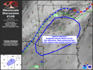
Mesoscale Discussion 0146
NWS Storm Prediction Center Norman OK
0206 PM CDT Mon Mar 19 2018Areas affected...Northeast MS...Northern AL...Southern TN
Concerning...Severe potential...Tornado Watch likely
Valid 191906Z - 192030Z
Probability of Watch Issuance...95 percent
SUMMARY...Tornado watch will be issued by 21z across portions of the
Mid-South. A few strong tornadoes are possible in addition to large
hail.DISCUSSION...Leading edge of mid-level drying/cooling is progressing
across the MS Delta region at roughly 35kt. Over the next few hours
lapse rates should adjust across western TN/northeast MS and deep
convection is expected to expand in response to this feature.
Conditions are becoming increasingly favorable for strong supercell
development as boundary-layer moisture is advancing into northern
MS/AL with mid 60s surface dew points now evident at TUP into
Winston county AL.Early-day thunderstorm cluster that spread across northern MS is now
into northern AL and this convection may impede deeper moisture
surge into the Middle TN region. However, a well-defined and
increasingly buoyant east-west boundary draped across northern MS/AL
should provide a focus for potentially tornadic supercells. Shear
profiles are becoming quite strong across this region and it appears
discrete storms will evolve over the next few hours in response to
approaching short-wave trough. Environmental parameters appear
supportive of potentially long-track tornadoes and this will be
addressed within the next few hours with a tornado watch.
-
Yes, it's kinda weird to have the neg NAO as we enter March and have it in largely positive territory during most of met winter.
-
If i have to wait for a sustained pattern shift I would rather have it in April/May/June when it's the height of tornado season and thermos are better to aid kinematics.
-
New ERTAF prediction for the last two weeks of March shows above average possibilities for tornadoes in the lower and mid MS Valley on north to central IL and IN. Pattern change anyone?
-
Based on 18z GFS and model trends I would say the PAH CWA from southern IL over to EVV has a good chance of svr on Monday March 19th. Interesting change from the winter wx advisories/warnings in that area this Sunday March 11th.
-
MO, IL, IN look somewhat interesting if we want to grasp at straws. Models have been showing something in this time period for awhile but location varies and it is still far out. We need to get some good southerly flow and stop these nw flow regimes and New England noreasters.
-
First tornado warning of this storm system Le Flore county in se OK.
-
2 minutes ago, BrandonC_TX said:
I wasn't really expecting the second line to go severe, but I was not going to rule it out either, seeing that I had outdoor plans (afternoon run) for today that I have now cancelled. Hearing thunder on the west side of Fort Worth right now, with dark clouds to my southeast.
That was a good call on my part I'd say.
Yes it was....Good luck on 2018 storm observations, spotting, chasing, etc.
-
Tor watch issued until 11 central time for the affected mesoscale discussion area. And the first svr t storm warning in this episode is for the Fort Worth area, technically outside of the current watch. Good reminder of the NWS statement that says "persons in or close to the watch area" should be on the lookout.
-
Tor watch issued until 11 central time for the affected mesoscale discussion area. First tornado watch of the year.
-
What an amazing temperature difference from just 4 days ago. We had record cold with temperatures near -10°F or colder along with wind chills around -20°F. Today, Springfield has broken a record high of at least 72°F and very Spring like outside. That is nearly an 85 plus degrees difference!
-
68/66 at Mena Arkansas. That dew can't be correct, can it?
-
Good to have GOES16 images. Would have liked to have a bit less cloudiness for this episode but there are breaks as one travels northeastward.
-
Confirmed tornado over Fort Sill this Sat. evening Oct. 21 shortly after 6 p.m. central time.
-
1
-
-
Hello, all. Just got back this Monday Aug. 28 from a week's vacation in the Ohio River valley that started with a view of the total eclipse from Harrisburg Illinois that was beyond awesome. Sorry for no pictures. I had expected the moon to cover the sun and show the corona but what I didn't expect and fully amazed me was the wall of darkness that came in from the west at totality. It was like an approaching t storm but in clear sky. Got about as dark as a full moon night and street lights came on. Lasted about two minutes. By far the most amazing thing I have seen in an astronomical sense. And no, IWX, I may be older but not THAT OLD! Ha! Ha!
-
1
-
-
I hope to be in the Carbondale/Marion IL area that day. Have been waiting years for this as well. If it's cloudy and you are in the path of totality I presume it will still get dark like night. Don't know for sure.
Tn Valley Severe Weather
in Tennessee Valley
Posted
I am assuming that the atmosphere is capped south of the present storms in northern Alabama and might unzip later as the LLJ increases and more forcing occurs.