

AfewUniversesBelowNormal
-
Posts
4,753 -
Joined
-
Last visited
Content Type
Profiles
Blogs
Forums
American Weather
Media Demo
Store
Gallery
Posts posted by AfewUniversesBelowNormal
-
-
I don't know, it would be hard to bet against a shorter term La Nina, at least in Nino 3. The subsurface warmer pool will push a cold wave to the surface in Nino 1.2 and 3 for at least the next month.
-
Here comes the La Nina.

My prediction is developing La Nina.
-
Hard to imagine the weekly of Nino 1.2 or 3 doesn't hit -1.0 in the coming weeks/months..
-
Just like everything, it's averaging out in time. Big time -AO develops as soon as the ice accretion starts.
-
To boot, we have La Nina wavelengths
-
Pretty bulllish La Nina sign
-
How about the coming +PNA/GOA Low on models days 14-15.
-
I like that the 2000-2019 base is holding.. warm Nino 4, cold Nino 1.2. Subsurface configuration has remained mostly active ENSO throughout the year.
-
I don't know what that has to do with ENSO! Subsurface configuration has held good amidst changing global conditions through the year.
-
Subsurface cold is fizzling a little bit. New cold pool around 140E suggests we probably stay +Neutral
-
This might be a record +AO here for a while. It's probably not as cold at the surface.
http://mp1.met.psu.edu/~fxg1/ENSHGTAVGNH_12z/ensloopmref.html
-
Finally signs of a changing Pacific on the 384hr GFS

-
We shouldn't be able to go too far into La Nina, not less than -0.7c I think. The Nino 3.4 is "Neutral/El Nino conditions"
-
government blocked me lol
It's not really possible to have this pattern (+PNA) with the subsurface the way it is, or an anomaly. I say this because the +PNA hasn't broken since last April 2018.

-
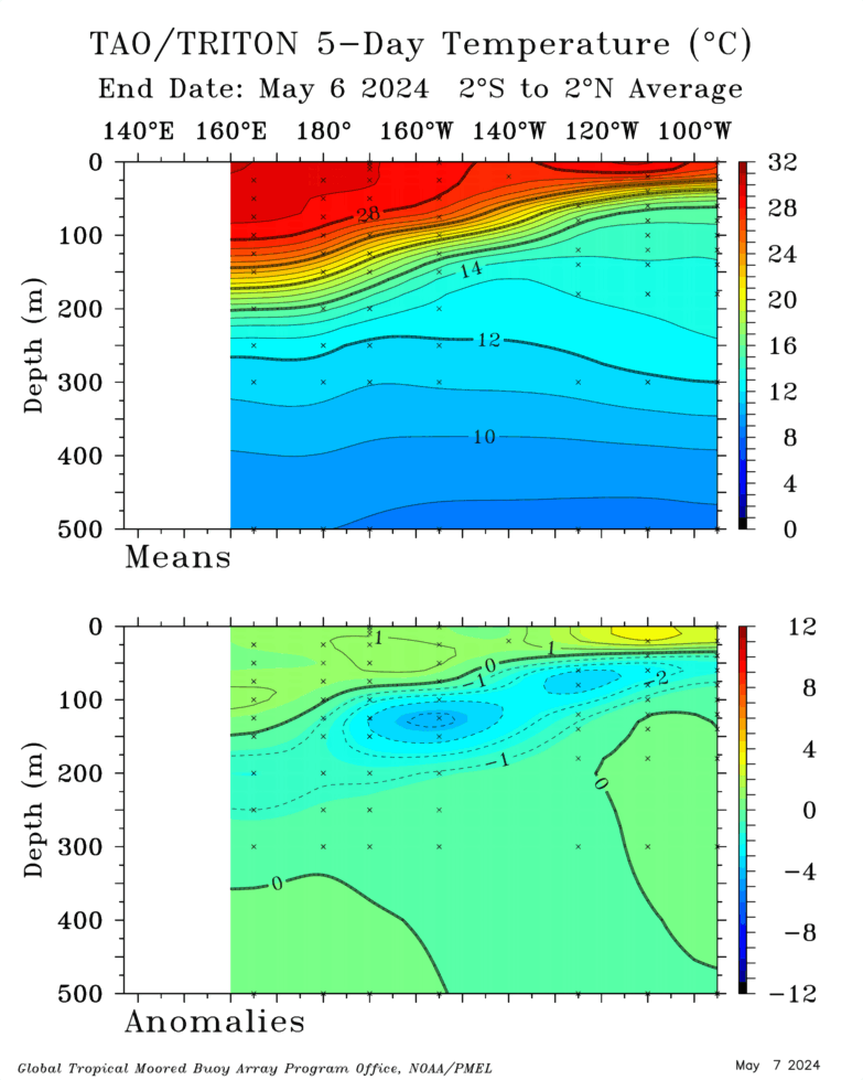
Look at this subsurface, we could have a Moderate La Nina burst at the surface in the next few weeks.
-
Images on NASA suggested otherwise, but that's just surface based. I would think "normally" we would be accelerating more ice loss by now.
-
I don't know, rate of decline of arctic ice seemed much more in the late 1990s through 2007. If you run a linear line forward for the last 12 years, this season is below normal in it's decrease.
-
I guess it would still be El Nino.. but that's using climate progression as a base. It was much different 2016 - before April 2018.
-
N Pacific pattern doesn't match subsurface data again.. this first happened in March or May 2018.
-
weird.. it's going to roll into -AO next Summer.
-
How is arctic ice doing today?
-
2 hours ago, 40/70 Benchmark said:
Care to elaborate?
The jet stream is north.
-
03-04 is a pretty good analog. Maybe with a blend of 12-13.
-
 2
2
-
-
It should be accelerating into September. May take it a year to catch up though.
2019 ENSO
in Weather Forecasting and Discussion
Posted
Looks like a La Nina making. I doubt anything real could develop in this environment.