

ILMRoss
-
Posts
658 -
Joined
-
Last visited
Content Type
Profiles
Blogs
Forums
American Weather
Media Demo
Store
Gallery
Posts posted by ILMRoss
-
-
2 minutes ago, BullCityWx said:
GFS and GFSENS are all hell yeah on storm #1 and hell no on storm #2.
EC and ECENS are all hell no on storm one and hell yes on storm #2.
¯\_(ツ)_/¯
It will be a few hours before i can really sit down and see whats going on but i think there's a case to be made
-
 2
2
-
 1
1
-
-
that euro run is one of the most ludicrous model runs i've ever seen in my 11 years of following these things. holy hell
-
4
-
 1
1
-
1
-
-
Oh my god, the hrrr. I'm thinking I put in my "doc, he's dead" comment way too early.
-
 2
2
-
-
Guys, I literally don’t think north or south really even matters at this point. It’s dead. What made this event really special was the potential for it to bomb off of the coast and draw a lot of moisture that way. With this speedier trend, not only is the duration cut, but we also completely lose the *magic* for lack of a better word of a sub 990 low off of the coast. For all intents and purposes, we may as well be dealing with a clipper with marginal temperatures. It’s a shame it’s worked out this way.
-
 3
3
-
-
We saw some great model runs with this. However, the final *nail* was the speed up today. By the time this storm bombed off the coast, it was too far away for us to reap benefits. I will hope for some token flakes but I will not be staying up until 3AM on Wednesday night to see it, I have things to do! I will not lose hope; over the years seems like every time hope is lost, some sort of event bails is out.
-
1
-
-
I wish I understood more about the MJO and how to track it etc. I really am just lost about this subject. I read up on it and still just don’t understand. Maybe someone knowledgeable could educate . Do you know what else would be cool? When we have a legit threat we do like a zoom call and discuss. We wouldn’t have many calls lol .
In a nutshell (and Eric Webb knows leagues more about this than I do), MJO follows an area of low level convergence (indicated by enhanced thunderstorms) over the Indian Ocean. Thunderstorms release latent heat which can help initiate/build ridges. That ridge can dig a trough downstream, that trough can then build a ridge downstream of it..... you get the idea. Each *phase* is linked to a different area where this convergence is happening, so each phase will make that wave train align a little differently. I know you said you read about this, but I think the literature can be a little too “academic” for laymen to understand.
-
I actually wasn't that discouraged by this suite and I think we live to see the next round. The outskirts of this forum (you could call it the highway 158 corridor, if that's a thing) are still flirting with the possibility of meaningful snow if you take some of today's runs verbatim. There were some subtle synoptic changes that I liked as well that caused storm tracks to either hold serve or inch southward. I'm not putting a stake in this yet.
-
1
-
2
-
-
Same here. Cannot find anything out there that updates Para from 1/21.
Pivotal Weather has updated GFS V16 runs. -
Isn't model watching your work? Surely all Meteorologist's sole purpose is to track potential snow?
I have a meteorology degree and I worked in the industry some, which is why I have the red tag, but i am currently working out of the industry.
To add, there are plenty of meteorologists (insurance folks, research, client facing folks, programmers, developers etc.) whose job is not purely to focus 7 days ahead. It’s become a very expansive industry! Unless I was media in Raleigh, or at a NWS WFO around the area, chances are I’d have other work besides figuring out if the triangle gets snow in 5 days.
-
4
-
-
I’ve been pretty optimistic and I still think we we’re in the game, especially if the high octane solutions of the GFS pan out. With a “big dog”, we don’t necessarily need to be in the epicenter to receive significant snows. That being said, if we trend towards less favorable solutions this suite, I will be moving on and catching up on some of the work I put off this week because I was model watching instead.
-
1
-
1
-
-
3 minutes ago, Buddy1987 said:
See and that’s the crappy part. I feel like the red headed step child. I’m literally in an area where either I’m almost rubbing salt in the wound for you guys or then in no mans land when DC crew is off their rockers because of too much confluence and you guys are cashing in to the south of me. Maybe we should just make a southern VA/northern NC forum and call it a day lollll. And I def understand the sentiment you share. I’ve been posting since the Eastern US weather board days. Only problem is I got to be in CT for all those, as I relocated down here like I said back in 2012. Posters like Typhoon Tip and ORHWxman are amazing and very knowledgeable people up that way. Def appreciate your insight on things.
I get it, I was a broadcast met at the station in Bluefield WV right out of college and that SWVA/SWV/i81 corridor until you reach Lexington is kind of geographic no-mans-land; not quite rocky enough to claim Appalachia, in between the north and the south. I keep on thinking back to March 2018, where it felt like a lot of systems dipped into us from the NW and storms that at first seemed like would exclusively be for SWVA surprised the models and clipped NC with some extra snow. I just keep on wondering how exactly this thing coming in from due W or WNW changes the typical trends that we have.
-
Just now, Buddy1987 said:
To be honest guys some of our big doozies living here now since 2012 have been the way we get these primaries to get close and then swing directly underneath us so we get the dynamics of that low still plus the developing ccb from the secondary taking over. I’m not gonna get so invested to where I get let down because that has become more of a reality here than not last couple winters. With that said CMC is a mauling in my book for north of I-40 and looks much more realistic with the primary. Gonna be a battle next couple days. @BornAgain13 where you at?! CMC will make you happy for sure.
we may be thinking about different systems... buddy i'm going to be honest with you man, i've been reading/chiming in here for years and when i check the forum after being busy for a few hours and i see you super happy my heart drops like a rock
-
3
-
-
Just now, Buddy1987 said:
I def like your logics and reasonings behind this!
And to answer your question, you're right, low pressures are generally going to divert around high pressures, and usually CAD drives our wonky miller B transfers to off the coast where cyclogenesis is more favorable. The issue is that the flank of the high on our side has been eroded over the last few runs, really weakening our CAD and nullifying that effect.
-
GFS just dropped a 150 mile shift south on us. I know that the *end result* isn't satisfying but this wasn't a disaster.
-
5
-
-
1 hour ago, StantonParkHoya said:
I wouldn’t let that piece of shit GFS get you too down.
To quote Neil Young, don't let it bring you down.
It's only castles burning. Hoping this suite brings a good trend.
-
1
-
-
I actually didn't mind the look on the Euro. I thought the ambient synoptic 'look' was fine enough, and you can chalk the storm underperformance to the strength of our shortwave. It appeared "limp" out the gate in California compared to other models and I think that set the tone for the rest of the run. I didn't think this was a fantastic model suite, but by no means are we out of the picture.
-
5
-
-
Kinda hated the look on the GFS, looked warmer on a wholesale level in our area and the ridge out west wasn't as robust.
CMC, I thought, was a way better look; colder system, excellent trends from previous run. Just need a better CAD high from that model.
-
42 minutes ago, griteater said:
Here is the noted trend on the EPS

That's a really stellar trend from a model we need on our team for this to be a credible threat.
-
2
-
1
-
-
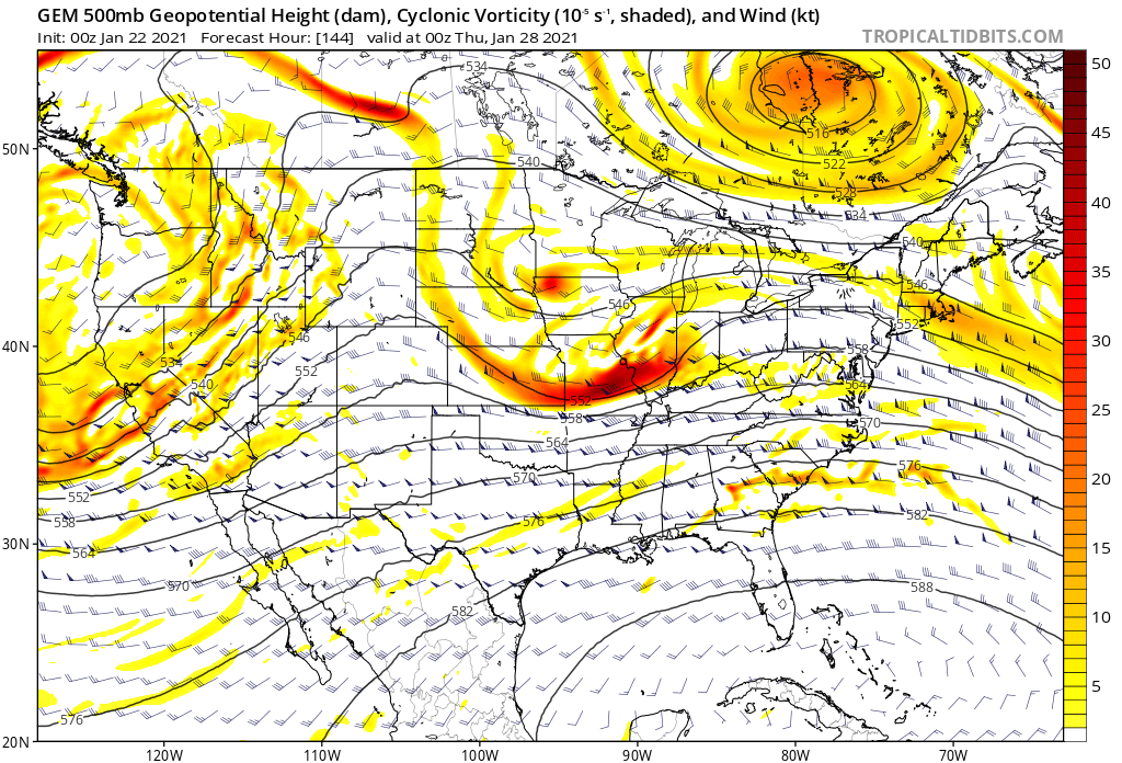
4 minutes ago, griteater said:
Yeah, GFS and Icon were about as good as we can hope for in this setup with the wave pass. CMC is the 'nightmare' scenario of the farther north wave track and the pesky closed upper low north of the Great Lakes (blue blob) which doesn't allow the damming high to build in. You can see the difference here between the 2 north of the Great Lakes
Yeah, to append my whole spiel about wave dynamics, also doesn't help when you don't have a great big damming high that forces your cyclogenesis off the coast.
-
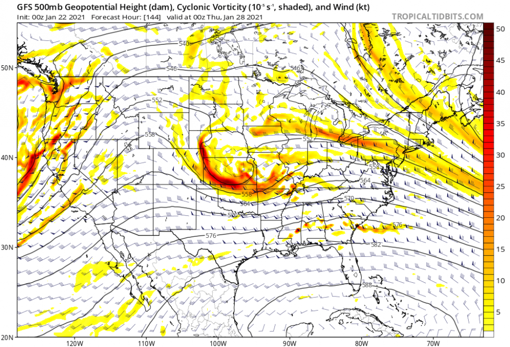
Something I'm noticing;
I think the secret sauce to this event is the ridge that fills in behind our shortwave. So let's look at the GFS:
 s
s
Two things to draw attention to. The wave coming into Cali is big, and stout, and robust, and really helping pump up the ridge to its east. For comparison sake, make mental note of the 558 decameter line, which nudges all the way into Wyoming. Nice ridge! That ridge is what's shunting our shortwave SE-ward and letting it bomb off the coast.
Now, the fresh Canadian for comparison:
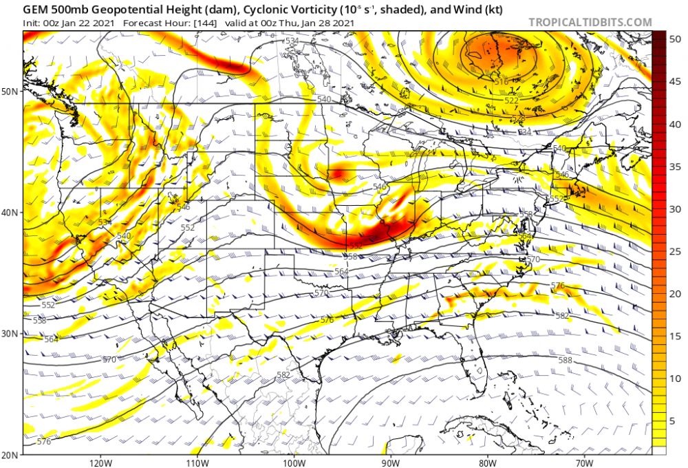
So, the Cali trough; it's a little weaker, it's a little faster, it's a little less robust. In response, the Wyoming ridge: barely seeing that 552 decameter line cross into Wyoming. It's a weaker ridge. In response, that ridge doesn't have the elbow grease to shunt our wave to the southeast which is why the mid-atlantic gets a good hit on the Canadian.
All of these troughs and ridges respond to one another- a stronger than forecast trough off the west coast could mean a stronger than forecasted ridge over the rockies which translates to a stronger, deeper trough near us... you get the idea.
So that's probably what I'm going to be paying the most attention to going forward.
-
4
-
-
Good grief its really tough to remain stoic and prudent and trying not to let one run sway your opinion when the GFS is spitting out banger after banger
-
3
-
-
Various Model Run(s) show My area(s) SENC, getting a dusting & pasteing..
looking back at Historical records..
Seems We get a "decent" pasteing every 3~4 years here, in Jan~Feb, so yeah,, were due..
Wilmington, NC Snowfall Database since 1870 (weather.gov)
If this is a legit “rapidly deepening bomb off the coast” kinda storm like some models show, the coast (and Wilmington) are totally in play for a little backside action. People sometimes think Jan 2000 was just a Raleigh storm, when in fact it’s been one of the handful of storms that has given ILM 4+ inches (it might be the biggest storm) in the last 30 years. Wilmington can cash in on high octane events... provided this is a high octane event in the first place. -
Mood swings on this board are in a league of their own. Honestly flipping more than the models are on this system
Until the GFS, Euro, Canadian, and UKmet all show a foot of snow from Atlanta to Charlotte to Raleigh, for 10 straight runs, with no mixing issues, and Cookout makes trays under 5 dollars again like they were when I was in high school, there will be mood swings. It is the nature of tracking winter storms in real time.-
5
-
1
-
4
-
-
15 minutes ago, BornAgain13 said:
How did the UK look? I know it only goes to 144 , but was it headed for a decent solution?
TBH, glanced at it to confirm my priors that this was a doom and gloom suite, and instead thought it looked pretty good. It only goes to hour 144, but it had a robust shortwave over OK going in a more eastward direction than some other models we've seen. Hopefully it's a harbinger to changes on the Euro, rolling out as we speak.
-
1
-

Mid to Long Term Discussion 2021
in Southeastern States
Posted
look i'm no moderator but i think it would be worthwhile to start a thread for this so that chatter on the weekend storm has its own place.