

ILMRoss
-
Posts
658 -
Joined
-
Last visited
Content Type
Profiles
Blogs
Forums
American Weather
Media Demo
Store
Gallery
Posts posted by ILMRoss
-
-
Just remember it's a whole lot easier for a nascent hurricane or old swirl to RI than it is a giant, tilted, sheared hurricane with 3 different concentric eyewalls.
That being said, if this storm can manage to get it's core in order in time for the gulf stream passage, then yeah, expect a second wind.
-
 2
2
-
-
Just now, Dunkman said:
What do you think about the coastline perhaps providing some friction to help Florence tighten up a bit? Seems like we've seen that happen in the past.
I think that you need a much smaller storm in order for that to really have an effect.
-
For the umpteenth time today Florence is trying to figure out how to eye wall.
Don't know how big of an issue dry air really is, we'd probably see more examples of outflow arcs racing away from the center on VIS if it was reallllllyyyyy a big problem.
If southerly shear has been over the storm all day, that's probably helped with some sinking air on the south side. If winds aloft have a slight southerly component, then winds are starting to turn counterclockwise with height- backing winds. That's going to cause the air to sink, and it's probably why we haven't seen any CDO maintenance on that side of the storm whatsoever.
If this shear really is expected to abate, we'll probably see any CDO persist a little longer.
-
2
-
 1
1
-
-
To elaborate. Most mets actually do use GFS and Euro in their shows. What people remember though, is the RPM, since its in 15 minute increments and it's easier to display, zoom in on, and understand.
-
2
-
-
I really wouldn't put too much stock into whatever the "futurecast" or "RPM" or whatever the weather model news stations show... We use it because WSI, the company most stations (WRAL for example) runs that model and makes it super easy to manipulate that model into easy to understand graphics. Personally I hate it. WSI doesn't offer anything with the NAM 3km, which I would use. Point being, I would absolutely take anything the RPM is saying with a grain of salt and instead use hurricane models and globals.
-
3
-
3
-
-
4 minutes ago, ncskywarn said:
Will the data collected this afternoon be incorporated into tonight's 00Z model run?
Yup... Hoping for some clarity
-
1
-
1
-
-
Not too enthused with this threat, looks like this storm evolution is going to involve a LP transfer, of which any modeled snow here occurs after this transfer. I have 0 confidence that any model will handle this right because it looks like a touch of CAD will develop before the approach of this system. There's going to be wonky solutions showing up in regards to this transfer simply because this CAD has to be modeled correctly before the transfer can be modeled correctly, and we're not going to see decent consensus until the higher res models come into play (what else is new). The Canadian has snow breaking out during the low transfer, which I don't buy at all. Don't think we'll really know how the thermals react to the transfer until the higher res models come into play as well. It does look like a solid freeze afterword though

-
1
-
-
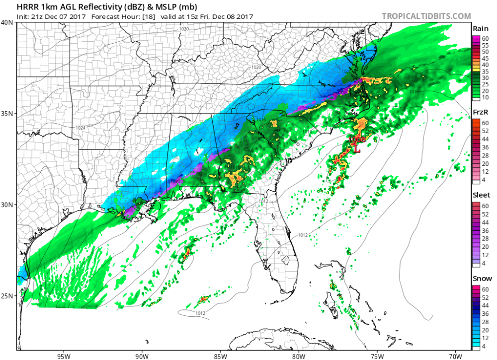
HRRR is very aggressive on precip arrival tomorrow morning. A lot of places currently on the SE flank of the R/S line could sneak in an inch or two given this setup before warmer temperatures aloft advect in. GSO sounding is going to be important to decipher!
-
1
-
-
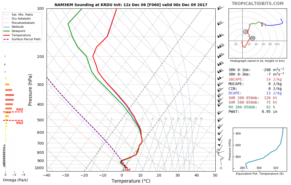
NAM 3k sounding for RDU on 00z Sat... Close but no cigar.
-
39 minutes ago, LovingGulfLows said:
If we learned anything from January this year, warm noses are not easy to "scour out". I'd be very skeptical of models showing heavy snow through dynamic cooling.
Different set up. That event featured a strong low pressure and generally amped set up. This event has a much weaker low, with less warm air advection that could strengthen a warm nose. Temps at low levels are the problem, and that's one of the *few* things that could be modeled completely wrong given the modeled precipitation rates.
-
1
-
-
Cool so I have a better chance of meeting Jim Cantore than I do salvaging something to make breakfast from today :/ I should of went grocery shopping while still in Wilmington

Mid to Long Term Discussion 2018
in Southeastern States
Posted
NAM is completely possible... I’m interpreting it as a warning shot.

Models are depicting a textbook worthy CAD Setup coming this Thursday... 1036ish in favored spot is hard to ignore. If there’s any setup to get crippling I77 corridor icestorms in November, it’s this.
.