

ILMRoss
-
Posts
665 -
Joined
-
Last visited
Content Type
Profiles
Blogs
Forums
American Weather
Media Demo
Store
Gallery
Posts posted by ILMRoss
-
-
Euro has had first snow shower potential for two runs in a row now for much of the southern/western piedmont coming up on Tuesday.
It has the potential to be a cute little appetizer. The upper air temps are there, surface temps are kinda blah. Rates dependent set-up. What’s new?
A lot of things still have to break right. If that shortwave diving in from the lakes comes in further from the rest/digs a little more, there might be some healthier precip. We’ll see. Winter!! We’re back baby!-
 3
3
-
-
Had a friend that said Birmingham got some flakes today. MPING has the Atlanta suburbs seeing some flakes. Wouldn’t be surprised some pretty widespread token flake action in the Carolinas tonight but if you want to see it time to get that coffee brewing.
-
Tbh probably the first time in a while I’m rooting for a warm winter
If we’re going to be in lockdown 2 at least let me get some more golf in.-
1
-
-
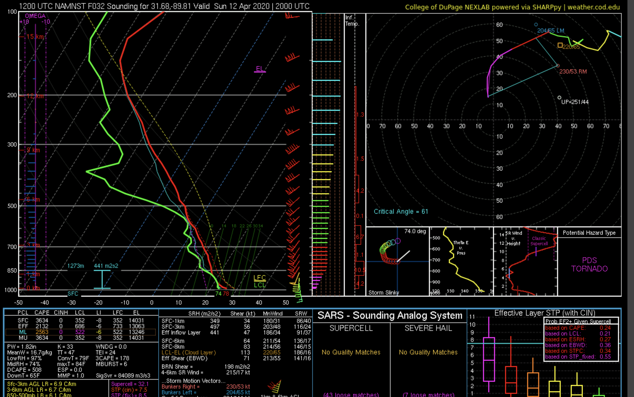
I would be cautious in interpreting these soundings from tropical tidbits. Strictly speaking, one should compare the virtual temperature of a lifted parcel to the virtual temperature of the background environment to assess lifted parcel buoyancy and CAPE, but their soundings use actual temperature. So this plot is misleading - the dashed line is probably a bit more to the right than indicated on here. Note that there is no MLCIN. This is actually a pretty good looking thermodynamic profile.
Attached is a similar sounding from the same approximate location and time, plotted correctly from dupage. You can see that there is actually quite a bit of low-level buoyancy for a lifted parcel.
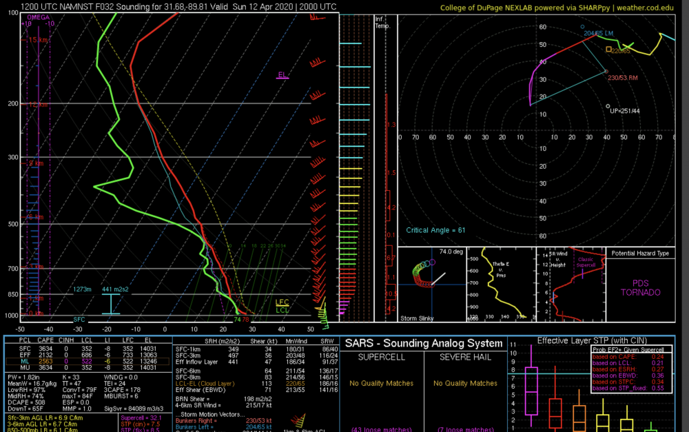
Ok, thank you, it’s been too long since I’ve taken thermo and my old textbook is an an attic somewhere so I’m in not much of a position to rebut. That dents my argument, although I’m still weary of low level buoyancy issues (that was a better-than-the-median sounding of the ones I glanced at) -
We really don’t know if the high ceiling will be realized until this time tomorrow. Every CAM has a different technique on how they render boundary layer mixing, which dictates how warm it gets at the surface. 3km NAM still displays a “mild” solution, in this case meh surface temperatures never get past the mid 70s and rising parcels don’t really have a ton of difference between their temp and the background temp until they rise to about 700 MB, according to this sounding I pulled. If the 3km is right, expect to see a lot of shallow, ‘baby’ supercells that struggle to stay alive amongst the strong low level shear. This solution would keep the SPC from slapping a high risk onto things.
Once again, all about boundary layer with this limiter, and other models (looking at you HRRR) will scare a lot of people because they have a tendency to overdue temps and therefore, CAPE.
-
3
-
-
Couple of thoughts;
-A weird wildcard to keep in mind is that model accuracy has gone down because of the COVID-19 outbreak. Why? Commercial planes are equipped with sensors that collect data that is fed into models. We're not talking hurricane hunters grade stuff here, but enough to increase our sampling to improve model outputs. Model verification has dipped significantly since the onset of the outbreak, and less air traffic is probably the reason why. Now- obviously models are still robust and should be trusted, but they may swing a little more/have a bit less consistency than usual.
Some NC specific things:
850MB winds will be whipping- the default to expect is a squall line with some embedded spin-ups. There are two ways this becomes something fiercer:
-The model trend has been ticking this thing slower and slower. The slower this goes, the more juiced the atmosphere can get ahead of the storms, and put far east places (New Bern, Edenton, E-City) in range for stronger storms/stronger tornado risk.
-The flip side to the above is Sunday's storms evolving into an MCS that rockets past guidance, and is offshore the NC Coast by midmorning Monday, allowing the atmosphere over Eastern NC to recover.
I think that the ceiling for NC on Monday is an enhanced risk; but keep an eye on things. Not a good idea to take your eye off the ball in high-ceiling events like this.
-
1
-
-
Stating the obvious, extremely high ceiling with this event. The 'best case' scenario is forcing coalescing the warm sector into a 'mega-squall', where you have one of those days that rack up 1000+ wind reports and a smattering of EF0-EF1 spin-ups on the line.
A baked in source of good news is that on Easter Sunday, a shining candidate for our first high risk of the year, stay-at-home orders due to COVID-19 will make it much easier to communicate to people what's going on.
-
1
-
-
Here’s why I and other mets aren’t trusting the HRRR;
 this is a pretty unrealistic profile for an overcast day; with a super adiabatic lapse rate at the surface this is a sounding you’d usually get if it were sunny! Sometimes even short term models struggle with the boundary layer and potential solar radiation.
 -
1
-
 3
3
-
 1
1
-
-
I like your optimism and hope that map verifies, but I’ll be shocked if everyone receives half of that.
Here’s my super heavy disclaimer; it was a casual map I made for most of my friends primarily in the eastern part of the state, so for the mountains and west this doesn’t exactly exude granular detail. That being said I think 2-5 across the northern half of the state is decently attainable; also feeling pretty good about the northern eastern corner seeing some pretty good totals -

Heard y’all like snow maps here’s what I made for my friends on Facebook-
5
-
1
-
 4
4
-
2
-
-
I've been impressed with how consistent the NAM has been with modeled precip. Even during the big storm in Dec 18, it had various runs where it was splotchy here and there with the QPF output....not this time. I'd expect the radar to look good and consistent tomorrow.

It hasn’t budged, a really remarkable performance that should be seared into the mind of any met going forward.-
5
-
-
Literally every zone this guy forecast is basically exactly the same “a few or a couple or several inches” ...why is the UNCC Grad student held in such high regard by some here, but real, actual meteorologists are not.
A quick note on Webb; he graduated with a degree in meteorology from NC State, which in my view makes him a meteorologist. I was in a class or two with him and can personally vouch the dude is pretty brilliant. Forecast against him at your own risk.-
10
-
1
-
 1
1
-
-
Warm nose crawling in on the 3k nam. I think that somebody curled a monkeys paw when they asked for a North trend.
-
1
-
1
-
1
-
-
You are correct, the synoptics are completely different this time though. Nothing in the upperlevels supports a extreme heavy snow event. More likely light to moderate.
Maybe not the Synoptics, but at the mesoscale level the tight thermal gradient will cause a lot of forcing via frontogenesis, as well as straight up warm air advection. A gfs-or-nam like event would support heavy snow bands.-
7
-
5
-
-
I can’t argue that but with that sounding, I’d imagine the only way we’d sleet is if our moisture got too shallow, right?
Verbatim though you’re correct, sorry for the half baked analysis I’m checking the thread via mobile.
Caution on using one temperature layer for warm noses, they can pop up anywhere from 900-700mb -
How on earth do we get sleet at RDU with this sounding?

I’ve seen a lot of great mets ask that exact question and then get sleet. It sounds like a such a meteorological cop out at this point but “never bet against sleet” is a safe strategy-
1
-
-
I love coming in here to say “I don’t know if a NW trend is possible” then logging back on to see the NAM has kicked a solid 80 miles north. NAM is a best case scenario where the energy out west *isnt* held back. Stay tuned to see if this becomes a globals vs high resolution situation
-
3
-
1
-
-
Some things I’m seeing;
Starting with the bad:
- I don’t know how much of a northwest trend is really *possible* given that the shortwave is coming from the northwest. A shift north could mean a flatter system overall and could mean less precip.
- Euro + UK combo saying no is a tough hand to bet against
- Betting in a late blooming coastal always scares me, a lot can go wrong with transporting moisture that far away from the LP
Now the good:
- Hi-Res models haven’t gotten a good crack at this yet. They’re not just good for thermals, they’re *much* better at rendering topography. Can’t emphasis enough how much of a night and day difference a mountain range looks on the gfs compared to the nam 3k. I mention that because any shortwave gets stretched and contracted in the mountain west and that has implications downstream. Our shortwave is being held back in dang Utah may look a little different in the hi-res stuff
- We have a wildcard I haven’t seen mentioned yet: this shortwave. It’s currently between Oregon and Hawaii and flies into Cali in 3 days like a bat out of hell. Pay attention to this storm; if it holds on some more of its integrity it could be a nice little boost to our Rockies shortwave

I’m pretty neutral on this storm, I’m not completely optimistic but it still has a lot of upside.-
2
-
2
-
-
To me it’s pretty solid that the CMC had a worst case scenario in how it handled the the Rockies energy (held it back) and the run still popped a coastal that gave NE NC a respectable event.
-
2
-
-
The way things are modeled right now, could this end up just being a thin strip of snow where the best rates and cold 850's overlap but rain on either side?
While this is on the table I recommend fast forwarding a couple of days before we analyze exactly *what* the snow corridor will look like-
2
-
-
With regard to precip, as others have alluded to, we need the northern stream shortwave to drop down farther to the west. We need it to drop from Montana down thru the spine of the Rockies as opposed to dropping down east of the Rockies. This improves the flow over the southeast for moisture return...specifically, it opens the door for more interaction with subtle subtropical waves that can inject moisture from Baja>Texas>Carolinas and VA. Here's the shift west with the wave shown in this loop of the last 2 runs of the Euro Control.
Pretty much this. With a 1040 parent high I think this is the pre-eminent feature to pay attention to in model runs going forward. I don’t think temps will be *that* much of an issue but I’m also ready to eat crow on that statement given this is still below the mason Dixon line.
.-
2
-
-
The reason for the change is an eastward trend in the shortwave that drops in to help create lift. Compare:

The 24 hour change in the gfs shows a 500 mile shift East. Because of this, the shortwave has a more positive tilt and produces less moisture transport. Still a very potent setup and I don’t think it would take too many tweaks to show snow again, but this is a setback.-
1
-
-
Surface temps are a non-issue with this storm for most folks, as modeled.
Let me explain:
If per say, the models were showing a profile with -4c 850mb temps, 0c 925mb temps, 1c 950mb temps and 3c surface temps. We would be in trouble in that scenario as we would be dealing with lots of white rain and a thick boundary layer that wouldn't want to give up the fight.
That is not what any of the models are showing for this storm. There are (on average for mby) showing -4c 850mb temps, -2c 925mb temps, -.5c 950mb temps, and 3c surface temps. As a result, the above freezing layer is only a few hundred feet deep at most on the globals, and any decent precip rates in that profile will quickly get the surface to 32/33. The globals never pick up on this, especially at this range. So it's no surprise they are showing 6 straight hours of 37 degree rain/snow. In reality,(if their thermal profiles are right). that would mostly be 32/33 snow for everyone fortunate enough to get good rates, assuming your location has the good thermal profile I described above.
While you are correct for the heavy precip core, I want to emphasize that *people on the fringes* of events like this still will have to worry about BL issues. In a hypothetical where the I-40 corridor gets an E-W spanning streak of the heaviest rates, places N of that (South Hill, Danville etc in this scenario) would still deal with mixing.-
1
-
-
Focus on Thursday. Thursday is a no frills, overrunning event where the atmosphere is hair trigger sensitive to disturbances due to the thermal gradient. The closing coastal needs a lot more to go right. Focus on Thursday.
-
2
-

Mid to Long Term Discussion 2020
in Southeastern States
Posted
I thought it was fun but I really doubt it will be replicated in future runs. Happy to be proven wrong.