

ILMRoss
-
Posts
665 -
Joined
-
Last visited
Content Type
Profiles
Blogs
Forums
American Weather
Media Demo
Store
Gallery
Posts posted by ILMRoss
-
-
4 minutes ago, griteater said:
Yeah, GFS and Icon were about as good as we can hope for in this setup with the wave pass. CMC is the 'nightmare' scenario of the farther north wave track and the pesky closed upper low north of the Great Lakes (blue blob) which doesn't allow the damming high to build in. You can see the difference here between the 2 north of the Great Lakes
Yeah, to append my whole spiel about wave dynamics, also doesn't help when you don't have a great big damming high that forces your cyclogenesis off the coast.
-
Something I'm noticing;
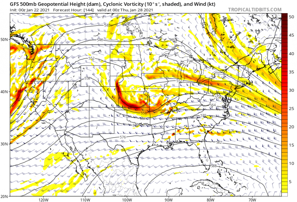
I think the secret sauce to this event is the ridge that fills in behind our shortwave. So let's look at the GFS:
 s
s
Two things to draw attention to. The wave coming into Cali is big, and stout, and robust, and really helping pump up the ridge to its east. For comparison sake, make mental note of the 558 decameter line, which nudges all the way into Wyoming. Nice ridge! That ridge is what's shunting our shortwave SE-ward and letting it bomb off the coast.
Now, the fresh Canadian for comparison:
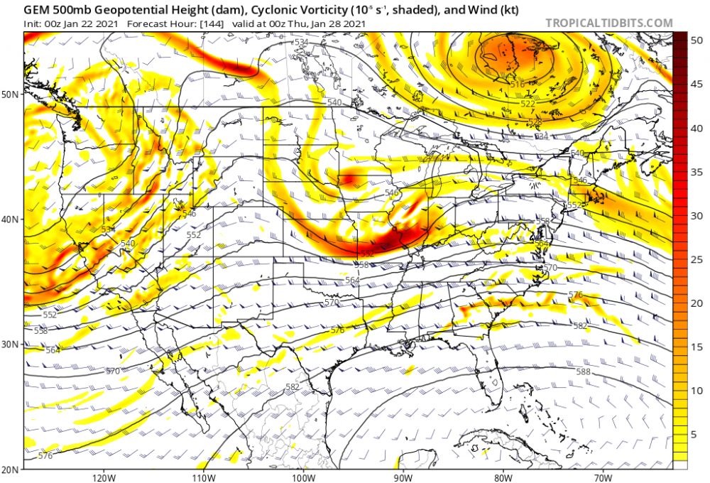
So, the Cali trough; it's a little weaker, it's a little faster, it's a little less robust. In response, the Wyoming ridge: barely seeing that 552 decameter line cross into Wyoming. It's a weaker ridge. In response, that ridge doesn't have the elbow grease to shunt our wave to the southeast which is why the mid-atlantic gets a good hit on the Canadian.
All of these troughs and ridges respond to one another- a stronger than forecast trough off the west coast could mean a stronger than forecasted ridge over the rockies which translates to a stronger, deeper trough near us... you get the idea.
So that's probably what I'm going to be paying the most attention to going forward.
-
 4
4
-
-
Good grief its really tough to remain stoic and prudent and trying not to let one run sway your opinion when the GFS is spitting out banger after banger
-
 3
3
-
-
Various Model Run(s) show My area(s) SENC, getting a dusting & pasteing..
looking back at Historical records..
Seems We get a "decent" pasteing every 3~4 years here, in Jan~Feb, so yeah,, were due..
Wilmington, NC Snowfall Database since 1870 (weather.gov)
If this is a legit “rapidly deepening bomb off the coast” kinda storm like some models show, the coast (and Wilmington) are totally in play for a little backside action. People sometimes think Jan 2000 was just a Raleigh storm, when in fact it’s been one of the handful of storms that has given ILM 4+ inches (it might be the biggest storm) in the last 30 years. Wilmington can cash in on high octane events... provided this is a high octane event in the first place. -
Mood swings on this board are in a league of their own. Honestly flipping more than the models are on this system
Until the GFS, Euro, Canadian, and UKmet all show a foot of snow from Atlanta to Charlotte to Raleigh, for 10 straight runs, with no mixing issues, and Cookout makes trays under 5 dollars again like they were when I was in high school, there will be mood swings. It is the nature of tracking winter storms in real time.-
5
-
1
-
 4
4
-
-
15 minutes ago, BornAgain13 said:
How did the UK look? I know it only goes to 144 , but was it headed for a decent solution?
TBH, glanced at it to confirm my priors that this was a doom and gloom suite, and instead thought it looked pretty good. It only goes to hour 144, but it had a robust shortwave over OK going in a more eastward direction than some other models we've seen. Hopefully it's a harbinger to changes on the Euro, rolling out as we speak.
-
1
-
-
1 hour ago, BullCityWx said:
You're the pro so you're seeing things I'm not I am sure. I'm concerned that the flow looked so progressive on the euro. If we can slow it down like we had yesterday at 12z then I think we've got a pretty good signal.
This is what I saw:
I really like to compare ensembles on if their "seeing" the S/W. GFS ENS did- check the indent over the Missouri Valley on 6z:

Euro ENS on same timeframe had a ridge in basically the same place:

We hem and haw about how "oh yeah its 7 days away the models dont know anything" but i generally believe the wheat separates from the chaff in the 7-9 day timeframe. If Euro got on board and showed a weaker ridge and stronger S/W signal, that was when I'd start salivating. Unfortunately, 12z models are bending towards the Euro. Hopefully the Euro produces better news in an hour.
-
1
-
1
-
-
Euro being a stick in the mud should give everyone great pause. There's pretty stark differences in its ensembles too. Temper your expectations in case the models slide into a Euro-ish direction today. That being said, if the euro and ensembles hop on board, we have a great (dare I say elite) long term signal.
-
3
-
-
Keep a lazy eye on next weekend. Euro was close to something.
-
2
-
-
I think that DT is generally pretty smart and a good forecaster. I may be biased, I think that my first "rodeo" following these things on models and online and in social media was the Boxing Day 2010 storm, where he was issuing those wild probability maps. I still get an adrenaline rush when I see that *ALEET* on my Facebook feed! That being said I do think he inflates numbers a little to get some more social media exposure. Take 30% off his forecast and I think you have a solid call.
Overall, I think the dye has been cast; There's going to be a front-end push of precip that could start as snow, and if it's heavy/quick enough it may surprise some folks/forecasters. It wouldn't be the first time I've seen that front-end overperform. Now when I say overperform, I mean "maybe an inch before flipping over", not "all snow event that will break forecasts". After a quick dry spell, the comma head will come in Friday night and drag through the northern 2/3s of the state and drop a half inch to an inch of accumulation, maybe a little more if you're lucky and you're sitting in a nice band. It will hopefully be enough to make things look pretty; great weather for sipping scotch. The place to be, I would say, is likely the NC/VA border, specifically near the mountains where elevation will help BL temps. If I were chasing, I would probably find a nice cabin in Fancy Gap.
-
1
-
-
Some thoughts:
- I would not rely on the 12km NAM precip shield depiction. Something I first noticed tracking that early Jan 2018 coastal is that it is pretty terrible and inconsistent at rendering these things, with a lot of features that aren't supported by synoptics/surface features. I think they're fun to look at but I don't take them very seriously. I trust the 3km depiction more.
- Flipside: I think somebody is going to get dry-slotted and shafted. Don't know who, but it's just the nature of these transfers of lows from inland to the coast.
- 3km NAM is showing the "splotchy" nature of the precip shield really well- that's how it will turn out! It will be feast or famine! One lucky locale may even see a little thundersnow, not out of the question! Don't know who.
-
2
-
2
-
-
Fun fact- The elephant in the room is that BL temps are pretty terrible for this event - the main difference with the RGEM is that it's totally colder; not really much else going on.
-
4
-
-
Just now, griteater said:
Euro Ens Mean looks about perfect to me for western areas for a week away...solid looking storm that is tracking south of you...32 deg line on the mean thru CLT....of course, this is one model
Thanks for the images yall, and completely agreed; for a week out it's a pretty lovely signal. I've been around long enough to bake a NW trend into any long range projection, so I like where we are sitting at now.
-
2
-
-
Euro with a bit of a monkey's paw run - oh, i hear you don't want suppression, how about this! Shout out to the folks that really get it good on that run but let's hope future runs settle down; a big sharp trough like that is begging to see a NW trend.
keep the euro ens images coming if you got em, should be a pretty enlightening run.
-
1
-
-
35 minutes ago, BullCityWx said:
Yeah, anything I get on Friday I consider a bonus. Sometimes scraping out 2-3" from an event like that can transition a winter from good to great so fingers crossed. Would you think if we do get 2-3" down and keep it around until Sunday, it helps us on Monday?
Anything helps - whether it's snow here that helps depress the surface temps some, or snow in S VA to keep the upstream airmass fresher for us, anything helps.
Regular ol GFS showed the potential really nicely- play your cards right and you get a legit, bona fide Miller A here.
Really excited to see what the Euro and it's ensembles show... If it shows a similar set up to the GFS this board is going to have an aneurism. I think suppression is still obviously on the table, there's a lot of shortwaves flying around and it wouldn't take much to smush this.
-
In terms of "potential" I am much more excited and anticipatory on the 12z suite for the *Monday event* rather than the *Friday event* , much higher ceiling for a much larger swath of people.
-
5
-
-
21 minutes ago, BornAgain13 said:
Some of you experts can weigh in on this , but does it seem like the GFS is on to something, by not being as wide spread event and just scattered? Or would you lean more toward the EURO/EPS , with it being more widespread?
I don't know if it's "on to something" per se; this is the nature of a lot of these ULLs that roll through. There are going to be competing forces within the feature that promote both rising air (more precip) and sinking air (less precip) which is the reason for the "splotchy" look on snow maps. As for the Euro, the more consistent snow map strikes me as just a difference in how the snow map is calculated and not the nature of the precip. Lastly, as a general rule, EPS will always have that smoothed-out look because it's an average of 51 different members. Those members themselves may be splotchy... but together they're look very uniform.
-
4
-
1
-
-
Please- don't worry about how a Euro run only gives table scraps to the triangle. These are fun things to gawk at but right now I would focus on what the globals are good at (synoptic track and larger scale features). Overall, some nice trends today with the ULL continuing to nudge south. I will say, you don't want the vort to pass too far south, or else the best dynamics (and heaviest precip) stay to our south as well. Let's get a few hi-res cycles closer to the event under our belt before we start a pity party for the triangle.
-
4
-
-
This is fun. Any trough this strong and sharp is worthy of scrutiny! That being said, the globals are starting to converge on an axis extending from Nashville-ish northward to have the best shot of noteworthy snow. If you're east of the apps, its about time to see some ensemble members show big hits to think that you're in the mix for a noteworthy event. If the trough wants to tilt negative as the trends today pointed to- I don't think the trough orientation is quite in our favor, and likely favors an inland low track.
Some optimism- It's a ton of energy- I wouldn't shut the door on a weak clipper system or some flurries as the base of the trough passes.
-
Really happy for PA.
Had a lunch with Tim Buckley (Greensboro met) right before I started on my real short broadcast career. He told me that the state college area is usually 1. Too inland for the coastals and 2. Too far east for the lake effect stuff. So a lot of what they see is nickel and dime stuff. Nice to see that region reel in a big one! -
5 minutes ago, griteater said:
But on Pivotal, the QPF (liquid) and ZR QPF are essentially the same amounts...so, they are just showing you how much precip will fall as freezing rain as opposed to how much ice accretion will occur. I'd go with something like a 50% reduction for this storm given temperatures, warmth pre-storm, etc. 0.4 inches of liquid = 0.2 ice accretion.
Pivotal has added ice accumulation maps using the FRAM estimate with a paid subscription (I don't have one) - https://vlab.ncep.noaa.gov/documents/10157/137122/FRAM_VLAB_Presentation.pdf/50ff7877-c52d-80f4-1413-b294db7710e9
Yeah, I should of been more specific. "ZR qpfs" was a pre-coffee phrase. Meant calculated ZR totals... there's a variety of reasons it always happens, its not just a 'models have no idea how to handle this!' situation. It's always a dash of precip coming in an hour or two later than forecast, dews being a smidge higher than forecast, more sleet than ZR, things like that that can combine to eat in what forecasts say.
-
Two things to keep in mind:
-There is some scientific backing behind "hi-res models do better with CADs", which at face value can scan as a weenie-ism sometimes. Hi-res models will have a much more detailed rendering of the apps and topography in general- as it turns out when forecasting a topographically-induced weather event, having the topography rendered as accurately as possible is important!
-I have never, in 9 winters of lurking and posting through this board, seen ZR qpfs be accurate. They are almost always inflated. The only legitimate ice storms I can really remember that mildly panned out were all in 2014.
-
3
-
-
On 12/10/2020 at 10:15 AM, ILMRoss said:
Whatever next week is fits neatly into the same category of the Monday system. It has upside, may be worth some token stuff, but a lot of things need to break in the right direction for it to be anything more than that. I would pay attention to how much the associated S/W digs/cuts off and if it keeps the integrity of that cut-off through the SE on today's model runs- some positive developments there would be cool.
Generally anything progged to put snow down in Oklahoma and moving laterally warrants at least a lazy eye for our Carolina folks.
^ here's a take that aged like milk in a hot car. it happens.
For next Wednesday, don't really think it's our storm unless you're above 2k feet (even then, apps may have moisture issues). That CAD high will need to get stronger or drop south some for this storm to be relevant to non-mountain folks.
-
2
-
-
Whatever next week is fits neatly into the same category of the Monday system. It has upside, may be worth some token stuff, but a lot of things need to break in the right direction for it to be anything more than that. I would pay attention to how much the associated S/W digs/cuts off and if it keeps the integrity of that cut-off through the SE on today's model runs- some positive developments there would be cool.
Generally anything progged to put snow down in Oklahoma and moving laterally warrants at least a lazy eye for our Carolina folks.
-
5
-

Mid to Long Term Discussion 2021
in Southeastern States
Posted
That's a really stellar trend from a model we need on our team for this to be a credible threat.