

ILMRoss
-
Posts
665 -
Joined
-
Last visited
Content Type
Profiles
Blogs
Forums
American Weather
Media Demo
Store
Gallery
Posts posted by ILMRoss
-
-
hi. i normally hang around the southern forums but i check in here every now and then. modeling consensus collapse sucks but wanted to chime in and say that the southern storms this year fit this exact same script. things get flat and dry around the twilight of the CAMs range before somehow, someway, something trends favorably to double qpf in the northern fringes, whether its a sharper wave or favorable northern stream tweaks.
generally i feel uneasy in richmond because i'm watching my once-in-a-decade snow slip through my fingers, but the script from other storms this years gives me a backstop. not trying to wishcast, just providing optimism. i recognize that this is an event that yall score if i score- rooting for us
-
 10
10
-
 1
1
-
-
feel like the nam has exaggerated northward push with both precip and ptype corridors all year. from the early january storm that took out water to the storm this past week, multiple runs had no snow over richmond city whatsoever. not really concerned
-
3
-
-
13 minutes ago, SoCoWx said:
Does anyone within the city limits (RVA) have a measurement of what we’ve gotten so far?
i'm at about two inches just south of the racetrack
northern areas haven't done fantastic i feel, petersburg/chesterfield stole a lot of the frontogen early bonus imo
-
3
-
-
7 minutes ago, wasnow215 said:
Nice to have a Met here! Welcome!
thanks! need to change my location, i now live in northside. really excited to get my first WSW worthy storm living here, just a bummer it comes on a sunday night
-
2
-
-
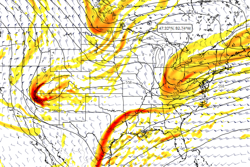
it will be important to see where the busts/booms are tomorrow across the ohio valley in relation to the model consensus
also don't post here a ton, mainly stick to more southern forums but like to check in on this thread every now and then
")
-
5
-
 1
1
-
-
1 hour ago, TARHEELPROGRAMMER88 said:
The means are starting to drop and moisture seems to be getting suppressed on ensemble. GFS actually looks to be cutting the first storm and suppressing the second on the op. However, the means went down across all ensembles in recent runs. We all have seen this show before. The cold will be there though.
this isn't a trend i would look particularly far into just yet. we're getting *the* canonical greenland block associated with so many of our big hits... i wouldn't fret at this stage unless this model suite weakens/moves that block in a meaningful way
-
6
-
3
-
-
pretty excited about the next 6 weeks or so, hope yall are well
-
3
-
-
the good news: the eye has lost some of its symmetry
the bad news: it's because of anvil spilling over from an absolutely monstrous hot tower
still a lot of room for strengthening, don't want to think about where this bottoms out at
-
8
-
-
GFS is fine, at this point just happy we're stopping the bleeding tonight.
-
3
-
1
-
-
Not going to lie if the 00zssssssssss windshield wipe and come back with a vengeance tonight the broadcast mets hedging for big totals are going to look really flippin smart
-
1
-
1
-
-
5 minutes ago, PantherJustin said:
And The model GOAT …. HRRR …. It was on an island of its own when Burrel started pumping it last Sat eve And it scored may as well give it a shot in our what have you done lately era
Yeah, I typically like trying to have the memory of a goldfish when assessing models but I understand some upstate folks really cashed out on that last storm. Upstate folks: some detail/context on what models were good, what models sucked, etc for that situation would be greatly appreciated if you can provide.
-
All the established mets have probably been bit by the NW trend so many times that they're pricing that into all forecasts going forward. They're betting that later guidance will wind-shield wiper back to more qpf-rich solutions, which is reasonable. How about let's get the 3km NAM past 00z Saturday before we really start cliff diving.
-
10
-
2
-
 2
2
-
-
jeez everyone totals were cut but still looks like a fine storm and we haven't even gotten to the GFS; feels like a funeral in here
-
1
-
4
-
-
RDU worrying about the best totals going to the east and relying on the NW trend to throw precipitation back? This must be what it feels like to live in Winston Salem.
-
4
-
 1
1
-
-
7 minutes ago, msuwx said:
I'm afraid it's now a trend over the last couple of cycles. 6z RGEM, 6z NAM, and 12z NAM all went in that direction.
Yeah sheesh. Looking at things seemed the NAM family made the trough a little more diffuse and spread out; less sharp and the precip must of responded to that.
-
Gonna be honest and maybe this is my inner weenie but I'm tossing that NAM run. As it was progressing on 5h I thought precip would hold serve. The precip shield at 21z Friday looked suspiciously dry.
-
3
-
1
-
 2
2
-
-
4 minutes ago, TARHEELPROGRAMMER88 said:
Well, looks like this is trending towards a sleet storm for RDU and points SE. The more amped it is, the more sleet we get.
I know I posted this entire sleet manifesto a little earlier but the caveat is that if that northern shortwave keeps digging southward and retains some of its punch/integrity, we really get the best of both worlds. Storm would be able to draw more moisture and heights would be depressed (and overall temp profiles would look a lot better). Amped doesn't necessarily mean more mixing issues if the shortwave that's being amped is also digging more to the south.
-
4
-
2
-
1
-
-
Don't want to jinx it but things look better on the GFS. I think a run with tangible improvements is on the way
-
5
-
3
-
-
Not like this is news to anybody but good lord the NAM is a nuke. Would be early frontrunner for *the* storm of the 2020s. Northern stream looked better and it would be really killer if we could keep up some more southerly adjustments with the northern stream. I really thought thermals would be less borderline for Raleigh but the beefier northern shortwave was able to add a bit more ridging and keep things relatively warm.
-
2
-
-
Going to put on my pessimistic hat on for a second... (I don't like making these posts so this is the only one I'm doing for this storm...)
The snow maps for the triangle are beautiful. Lovely. It's a picturesque spike that punctures straight through Wake County. I'll tell you how I'm interpreting it right now- I'm mentally taking it and shoving it 30 miles to the north. I've sat through so many of these storm threads and seen Wake County in a lovely position just to see sleet. I've been snakebitten so. many. times. We are consistently finding new ways to end up with sleet. So as I see more of these perfect snow maps the pit in my stomach just grows larger.
I'm currently put off by how skinny and shaky the modeled snow corridor is, it really leaves no margin of error. If our system ends up weaker and strung out, the snow corridor isn't simply shoved south- it will shrink with decreased lift and precipitation will struggle to get past, say, highway 1. A stronger version of our current system will likely shift the sleet line north of Wake County. Raleigh folks: we look good right now but man I don't like this tenuous balancing act.
What I'm looking and hoping for tonight is our northern shortwave somehow beefing up a little more- dropping down with a little more pep in its step- and being able to dig south more. qpf wouldn't be an issue and I think this would depress heights enough to make mixing in the triangle way less of an issue.
-
3
-
2
-
 1
1
-
1
-
-
GFS with 4 distinct shortwaves to keep track up at hour 84, lol good luck. Forecasting this is like defending one of those Chiefs plays where they have Tyreek Hill in motion and Kelce in the slot with two of their speed guys in the WR role
-
4
-
9
-
-
8 minutes ago, PantherJustin said:
How does this guy have so much met street Cred? I’ve been on here since 2013 and see his name every storm and he’s never been right on anything or remotely close. I hope ppl don’t actually pay this

He's fine. He throws enough models/jargon around to give off a "hey kid, let me show you what's really going on" kind of vibe but explains it well enough to be accessible to the public. He can be a jerk but I think people actually kind of like that schtick sometimes. But I think he generally knows what he's talking about and my Richmond friends really like him. I think every region has "their guy". For CLT it is Panovich. For a while in RDU is was Fish. For RIC I think it's DT moreso than a lot of the broadcast people simply because he's been savvy on social media for a decade now. I also like his snow map designs... Usually pretty clean and easy to read (but usually about 20% overdone lol)
-
5
-
-
Weird to see the TV folks so keyed in this early.

When the surface temps are a near lock to cooperate you can go ahead and telegraph to expect a major winter storm since sensible impacts are pretty similar across all precipitation types.-
6
-
-
Would be high quality if the Euro comes and it digs its heels in on the more amplified solution.
-
1
-
Richmond Metro/Hampton Roads Area Discussion
in Mid Atlantic
Posted
good luck, hope this turns out alright