

mahantango#1
-
Posts
5,058 -
Joined
-
Last visited
Content Type
Profiles
Blogs
Forums
American Weather
Media Demo
Store
Gallery
Everything posted by mahantango#1
-

Central Pa. Summer 2024
mahantango#1 replied to mahantango#1's topic in Upstate New York/Pennsylvania
542NOUS41 KCTP 020153 CCBPNSCTPPAZ004>006-010>012-017>019-024>028-033>037-041-042-045-046-049>053-056>059-063>066-022315-Public Information Statement...CorrectedNational Weather Service State College PA952 PM EDT Mon Jul 1 2024...NWS Damage Survey for 06/29/24 Downburst Event....Overview...NWS State College meteorologists have confirmed that a downburstoccurred late Saturday afternoon, June 29th, 2024 in northernDauphin County. Maximum wind speeds were estimated to be between 75and 95 mph....Millersburg Downburst...Peak Wind /Estimated/: 75-95 mphPath Length /statute/: 3 milesPath Width /maximum/: 1.2 milesFatalities: 0Injuries: 0Start Date: June 29, 2024Start Time: 5:38PM EDTStart Location: Millersburg /Dauphin County/ PAStart Lat/Lon: 40.54390 / -76.95261End Date: June 29, 2024End Time: 5:42PM EDTEnd Location: Millersburg /Dauphin County/ PAEnd Lat/Lon: 40.54562 / -76.90943Survey Summary:A line of severe thunderstorms began to produce wind damage in thetown of Millersburg at the Millersburg Area High School, locatedjust off North Street. A press box structure located above and justbehind a set of metal bleachers adjacent to the school`s athleticfield was blown off its supporting metal beams/foundation andlargely destroyed. A small ticket office on the other side of thefield was blown off its unsecured cement foundation pad and washeavily damaged when it impacted a long length of bleachers next tothe field.The line then continued eastward and produced sporadic winddamage within several residential areas across Millersburg alongand East of Route 25. The damage consisted mostly of downed largebranches, as well as a few snapped and/or uprooted softwood andhardwood trees.The last observed area of storm damage in Millersburg was nearLandfill Road, where a few more more trees were snapped, or hadsignificant limb damage. The storm appeared to weaken farther tothe east, as no more damage points were observed.We would like to thank the Dauphin County Emergency ManagementAgency, Upper Paxton Township Fire/EOC officials, the local areaSkywarn Spotter and HAM Operator networks for their assistance.We`d also like to thank members of the public who reported stormrelated impacts.&&NOTE:The information in this statement is preliminary and subject tochange pending final review of the event and publication in NWSStorm Data. -
Central Pa. Summer 2024
mahantango#1 replied to mahantango#1's topic in Upstate New York/Pennsylvania
-
Central Pa. Summer 2024
mahantango#1 replied to mahantango#1's topic in Upstate New York/Pennsylvania
https://www.local21news.com/news/local/millersburg-press-box-destroyed-in-saturday-evening-storm?fbclid=IwZXh0bgNhZW0CMTEAAR2sQ4W3rCns78NFiKZHjtpoNwSkVZuP2DHTGfpTB94Gr_sZ9N-7qz1Hc_8_aem_ogUgyS4lYUkhqzeme_ddng# -
Central Pa. Summer 2024
mahantango#1 replied to mahantango#1's topic in Upstate New York/Pennsylvania
SEVERE THUNDERSTORM WATCH OUTLINE UPDATE FOR WS 489 NWS STORM PREDICTION CENTER NORMAN OK 1110 AM EDT SUN JUN 30 2024 SEVERE THUNDERSTORM WATCH 489 IS IN EFFECT UNTIL 700 PM EDT FOR THE FOLLOWING LOCATIONS PAC001-011-015-017-025-027-029-035-037-041-043-045-055-057-061- 067-069-071-075-077-079-081-087-089-091-093-095-097-099-101-103- 107-109-113-115-119-127-131-133-302300- /O.NEW.KWNS.SV.A.0489.240630T1510Z-240630T2300Z/ PA . PENNSYLVANIA COUNTIES INCLUDED ARE ADAMS BERKS BRADFORD BUCKS CARBON CENTRE CHESTER CLINTON COLUMBIA CUMBERLAND DAUPHIN DELAWARE FRANKLIN FULTON HUNTINGDON JUNIATA LACKAWANNA LANCASTER LEBANON LEHIGH LUZERNE LYCOMING MIFFLIN MONROE MONTGOMERY MONTOUR NORTHAMPTON NORTHUMBERLAND PERRY PHILADELPHIA PIKE SCHUYLKILL SNYDER SULLIVAN SUSQUEHANNA UNION WAYNE WYOMING YORK -
Central Pa. Summer 2024
mahantango#1 replied to mahantango#1's topic in Upstate New York/Pennsylvania
A 77 dewpoint now, feels really tropical outside. -
Central Pa. Summer 2024
mahantango#1 replied to mahantango#1's topic in Upstate New York/Pennsylvania
Had a good storm. That wind and driving rain. Tornado warning was issued the next county over from me which is about 300ft from me. Had a gust of 38 but since I live down in the hallow the winds were much stronger up on the hill. Picked up .52 rain from the storm. I was getting concerned we would have to go to the basement pic is before the storm. But right before it got here it was darker than that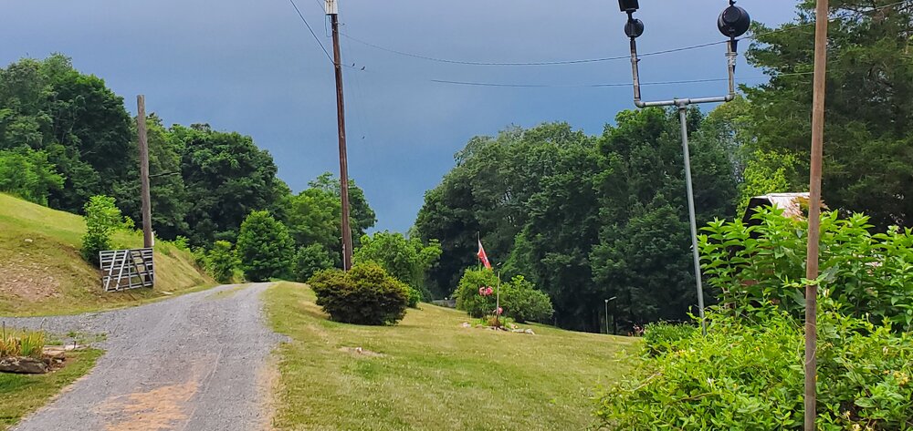
-
Central Pa. Summer 2024
mahantango#1 replied to mahantango#1's topic in Upstate New York/Pennsylvania
Wonder if it will be expanded eastward later? -
Central Pa. Summer 2024
mahantango#1 replied to mahantango#1's topic in Upstate New York/Pennsylvania
Well take what we get at this point. I'm wondering if we'll see severe weather later. -
Central Pa. Summer 2024
mahantango#1 replied to mahantango#1's topic in Upstate New York/Pennsylvania
NWS has the same amount of rain for my area too. -
Central Pa. Summer 2024
mahantango#1 replied to mahantango#1's topic in Upstate New York/Pennsylvania
Will we we see severe storms later today? Hazardous Weather Outlook National Weather Service State College PA 713 AM EDT Sat Jun 29 2024 PAZ033>036-056>059-063>066-301115- Somerset-Bedford-Fulton-Franklin-Perry-Dauphin-Schuylkill-Lebanon- Cumberland-Adams-York-Lancaster- 713 AM EDT Sat Jun 29 2024 This Hazardous Weather Outlook is for central Pennsylvania. .DAY ONE...Today and tonight. Scattered severe thunderstorms with localized damaging wind gusts are possible this afternoon and evening. .DAYS TWO THROUGH SEVEN...Sunday through Friday. Strong to severe thunderstorms with gusty winds and small hail are possible again on Sunday. .SPOTTER INFORMATION STATEMENT... Spotters are encouraged to report significant hazardous weather. $$ Hazardous Weather Outlook National Weather Service State College PA 713 AM EDT Sat Jun 29 2024 PAZ006-011-012-017>019-024>028-037-041-042-045-046-049>053-301115- Potter-Cameron-Northern Clinton-Clearfield-Northern Centre- Southern Centre-Cambria-Blair-Huntingdon-Mifflin-Juniata-Tioga- Northern Lycoming-Sullivan-Southern Clinton-Southern Lycoming-Union- Snyder-Montour-Northumberland-Columbia- 713 AM EDT Sat Jun 29 2024 ...FLOOD WATCH IN EFFECT FROM 8 AM EDT THIS MORNING THROUGH LATE TONIGHT... This Hazardous Weather Outlook is for central Pennsylvania. .DAY ONE...Today and tonight. Please listen to NOAA Weather Radio or go to weather.gov/StateCollege on the internet for more information about the following hazards. Flood Watch. -
Central Pa. Summer 2024
mahantango#1 replied to mahantango#1's topic in Upstate New York/Pennsylvania
NWS has my area getting .75-1.00 tomorrow night -
Central Pa. Summer 2024
mahantango#1 replied to mahantango#1's topic in Upstate New York/Pennsylvania
52 was my low. -
Central Pa. Summer 2024
mahantango#1 replied to mahantango#1's topic in Upstate New York/Pennsylvania
NWS State College: .SHORT TERM /SATURDAY THROUGH SATURDAY NIGHT/... -- Changed Discussion -- GEFS and NBM indicates an increasing/anomalously strong south/SSW llvl return flow developing for later tonight through Saturday with the anomaly of the LLVL v-component reaching around plus 3 sigma across northern PA and a solid 2+ sigma elsewhere across Central and Southern PA Saturday afternoon and evening. Latest model data suggests 30-40kt LLJ from the south- southwest will drive some showers and elevated t-storms over west central PA later tonight into early Saturday morning. This strong vertical speed and directional shear coupled with increasing meso-B lift associated with the Right Entrance region of a 100+ KT jet to our north will support the likelihood of another fairly widespread strong to severe convective events with a distinct threat for isolated tornadoes with discrete cells, BKN-S signatures that are accompanied by a near perpendicular deep layer shear component to their long axis. SPC not only expanded the SLGT risk across all but our far SE CWA, but also introduced a 5% TOR threat across roughly the NW 40 percent of PA. The belt of strong 850mb flow will transport rich low level moisture (dewpoints in the upper 60s to lower 70s) northeastward along/ahead of a cold front this weekend. PWAT values are forecast to reach 2-2.5 inches on Saturday or +2-3SD. The anomalous, deep-layer moisture will support risk of heavy to potentially excessive rainfall with point amounts of 3 inches possible in places experiencing multiple TSRA. WPC has maintained a broad MRGL risk, but the setup will likely yield an upgrade to SLGT risk particularly where FFGs are reduced. Although mid lvl lapse rates may remain weak, high dewpoints and diurnal heating should fuel at least moderate buoyancy by mid/late afternoon. The influence of early day clouds/waning overnight convection could be a key/limiting factor. The mid level cap is similar in strength to our past SVR event this past Wednesday with 700 mb temps in the 8-9.5C range and weak broad scale forcing until the afternoon/evening arrival of the better omega field beneath the favorable RR Quad of the aforementioned ULVL jet. Convection should decrease in coverage and intensity into Saturday night, which will be warm and muggy with lows 65-75. -- End Changed Discussion -- -
Central Pa. Summer 2024
mahantango#1 replied to mahantango#1's topic in Upstate New York/Pennsylvania
We used to camp up at Pleasant Hills Resort for about 8 years in a popup. -
Central Pa. Summer 2024
mahantango#1 replied to mahantango#1's topic in Upstate New York/Pennsylvania
NWS is mentioning Saturday in their discussion for possible severe weather. -
Central Pa. Summer 2024
mahantango#1 replied to mahantango#1's topic in Upstate New York/Pennsylvania
Received .47 rain from yesterdays 2 thunderstorms -
Central Pa. Summer 2024
mahantango#1 replied to mahantango#1's topic in Upstate New York/Pennsylvania
Had that thunderstorm lots of wind even though I only recorded a gust of 27 the wind up in the mountain was roaring. I heard trees snapping and falling over. Being I live down at the base of the mountain I'm somewhat protected from most of the wind. There are a lot of trees down in the Upper Dauphin County area. Had .06 rain from the storm. -
Central Pa. Summer 2024
mahantango#1 replied to mahantango#1's topic in Upstate New York/Pennsylvania
NWs dropped my rainfall down to a tenth to a quarter of and inch -
Central Pa. Summer 2024
mahantango#1 replied to mahantango#1's topic in Upstate New York/Pennsylvania
That guy has been working on that same small area for hours now. I don't think I'll hire him. -
Central Pa. Summer 2024
mahantango#1 replied to mahantango#1's topic in Upstate New York/Pennsylvania
Sun has been out in full force for better than an hour now. 83 dp 69. -
Central Pa. Summer 2024
mahantango#1 replied to mahantango#1's topic in Upstate New York/Pennsylvania
Big discrepancy on the rainfall totals till tomorrow morning ABC27 says .25, NWS has me getting .50-,75 -
Central Pa. Summer 2024
mahantango#1 replied to mahantango#1's topic in Upstate New York/Pennsylvania
-
Central Pa. Summer 2024
mahantango#1 replied to mahantango#1's topic in Upstate New York/Pennsylvania
84 wS the high. -
Central Pa. Summer 2024
mahantango#1 replied to mahantango#1's topic in Upstate New York/Pennsylvania
68 here dp 64 -
Central Pa. Summer 2024
mahantango#1 replied to mahantango#1's topic in Upstate New York/Pennsylvania
Picked up .01 rain last evening. NWS mentions possibility of severe weather Wednesday.


