

mahantango#1
-
Posts
5,058 -
Joined
-
Last visited
Content Type
Profiles
Blogs
Forums
American Weather
Media Demo
Store
Gallery
Everything posted by mahantango#1
-

Central Pa. Summer 2024
mahantango#1 replied to mahantango#1's topic in Upstate New York/Pennsylvania
-
Central Pa. Summer 2024
mahantango#1 replied to mahantango#1's topic in Upstate New York/Pennsylvania
.07 rainfall today. -
Central Pa. Summer 2024
mahantango#1 replied to mahantango#1's topic in Upstate New York/Pennsylvania
Severe Thunderstorm Watch SEVERE THUNDERSTORM WATCH OUTLINE UPDATE FOR WS 552 NWS STORM PREDICTION CENTER NORMAN OK 100 PM EDT WED JUL 17 2024 SEVERE THUNDERSTORM WATCH 552 IS IN EFFECT UNTIL 800 PM EDT FOR THE FOLLOWING LOCATIONS PAC001-011-017-025-029-037-043-045-069-071-075-077-079-089-091- 093-095-097-101-103-107-115-127-131-133-180000- /O.NEW.KWNS.SV.A.0552.240717T1700Z-240718T0000Z/ PA . PENNSYLVANIA COUNTIES INCLUDED ARE ADAMS BERKS BUCKS CARBON CHESTER COLUMBIA DAUPHIN DELAWARE LACKAWANNA LANCASTER LEBANON LEHIGH LUZERNE MONROE MONTGOMERY MONTOUR NORTHAMPTON NORTHUMBERLAND PHILADELPHIA PIKE SCHUYLKILL SUSQUEHANNA WAYNE WYOMING YORK -
Central Pa. Summer 2024
mahantango#1 replied to mahantango#1's topic in Upstate New York/Pennsylvania
Just hit 90 today. NWS had me at 86 for the high this morning. -
Central Pa. Summer 2024
mahantango#1 replied to mahantango#1's topic in Upstate New York/Pennsylvania
My NWS forecast seems pretty optimistic for rain today: Today Showers and thunderstorms likely, then showers and possibly a thunderstorm after 3pm. High near 86. Calm wind becoming west 5 to 7 mph in the morning. Chance of precipitation is 80%. New rainfall amounts between a half and three quarters of an inch possible. -
Central Pa. Summer 2024
mahantango#1 replied to mahantango#1's topic in Upstate New York/Pennsylvania
-
Central Pa. Summer 2024
mahantango#1 replied to mahantango#1's topic in Upstate New York/Pennsylvania
Missed out on the rain so far this week. Well theres always tomorrow -
Central Pa. Summer 2024
mahantango#1 replied to mahantango#1's topic in Upstate New York/Pennsylvania
Well have to wait to confirm this with DT! -
Central Pa. Summer 2024
mahantango#1 replied to mahantango#1's topic in Upstate New York/Pennsylvania
We don't have many this year as compared to a few years ago. And they are Voiding the feeder this year. Somethings going g on with them. The last 2 years they were fighting at the feeder, not this year as there are very few of them. -
Central Pa. Summer 2024
mahantango#1 replied to mahantango#1's topic in Upstate New York/Pennsylvania
ABC-27 is calling for scattered showers and storms. While NWS is calling for a solid line of them producing .25-.50. Will NWS eventually succumb to 27's forecast? From NWS: More specifically with respect to timing of the convection today, the latest HREF and its members shows the main round of storms firing up along a line from Near KELZ south to KFIG, KUNV and KAOO between 17-18Z before solidifying into a likely line of storms and plowing across the Susq Valley. A second, weaker MCS near or just to the south of the Mason Dixon line will support additional TSRA that could linger through the early evening hours southeast of the I-81 corrido -
Central Pa. Summer 2024
mahantango#1 replied to mahantango#1's topic in Upstate New York/Pennsylvania
-
Central Pa. Summer 2024
mahantango#1 replied to mahantango#1's topic in Upstate New York/Pennsylvania
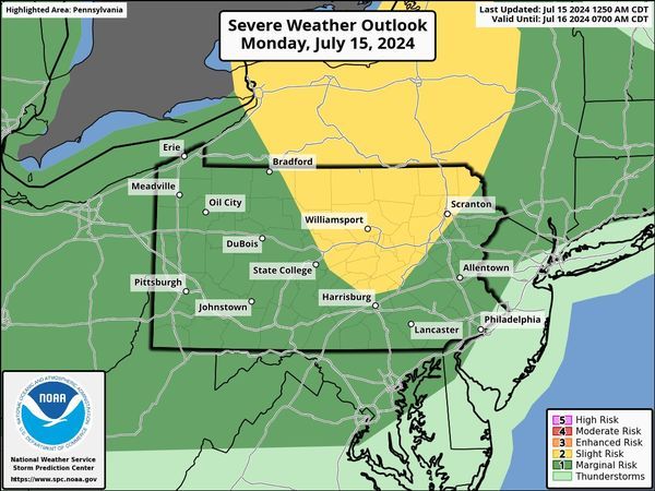
SEVERE THUNDERSTORM WATCH OUTLINE UPDATE FOR WS 538 NWS STORM PREDICTION CENTER NORMAN OK 1220 PM EDT MON JUL 15 2024 SEVERE THUNDERSTORM WATCH 538 IS IN EFFECT UNTIL 700 PM EDT FOR THE FOLLOWING LOCATIONS PAC015-023-035-047-081-083-105-113-115-117-123-131-152300- /O.NEW.KWNS.SV.A.0538.240715T1620Z-240715T2300Z/ PA . PENNSYLVANIA COUNTIES INCLUDED ARE BRADFORD CAMERON CLINTON ELK LYCOMING MCKEAN POTTER SULLIVAN SUSQUEHANNA TIOGA WARREN WYOMING $$ -
Central Pa. Summer 2024
mahantango#1 replied to mahantango#1's topic in Upstate New York/Pennsylvania
lets not over do it outside the next two days. URGENT - WEATHER MESSAGE National Weather Service State College PA 354 AM EDT Mon Jul 15 2024 PAZ036-056-057-059-063>066-152100- /O.CON.KCTP.EH.W.0001.240715T1600Z-240717T0000Z/ /O.CON.KCTP.HT.Y.0004.000000T0000Z-240715T1600Z/ Franklin-Perry-Dauphin-Lebanon-Cumberland-Adams-York-Lancaster- Including the cities of Newport, Lancaster, Harrisburg, Chambersburg, Hershey, Gettysburg, York, Carlisle, and Lebanon 354 AM EDT Mon Jul 15 2024 ...HEAT ADVISORY REMAINS IN EFFECT UNTIL NOON EDT TODAY... ...EXCESSIVE HEAT WARNING REMAINS IN EFFECT FROM NOON TODAY TO 8 PM EDT TUESDAY... * WHAT...Oppressive heat with peak heat index values around 105 degrees this afternoon and again Tuesday afternoon. * WHERE...Adams, Cumberland, Dauphin, Franklin, Lancaster, Lebanon, Perry, and York Counties. * WHEN...For the Heat Advisory, until noon EDT today. For the Excessive Heat Warning, from noon today to 8 PM EDT Tuesday. * IMPACTS...Heat related illnesses increase significantly during extreme heat and high humidity events. PRECAUTIONARY/PREPAREDNESS ACTIONS... Drink plenty of fluids, stay out of the sun, and stay in an air-conditioned room. The heat may be life-threatening to the elderly and those in poor health, due to prolonged exposure without air conditioning. -
Central Pa. Summer 2024
mahantango#1 replied to mahantango#1's topic in Upstate New York/Pennsylvania
-
Central Pa. Summer 2024
mahantango#1 replied to mahantango#1's topic in Upstate New York/Pennsylvania
-
Central Pa. Summer 2024
mahantango#1 replied to mahantango#1's topic in Upstate New York/Pennsylvania
Wednesday? NWS has me getting in the low 90's with storms later. -
Central Pa. Summer 2024
mahantango#1 replied to mahantango#1's topic in Upstate New York/Pennsylvania
Maybe Candersons desert will be turned into a flood zone. -
Central Pa. Summer 2024
mahantango#1 replied to mahantango#1's topic in Upstate New York/Pennsylvania
84 here. -
Central Pa. Summer 2024
mahantango#1 replied to mahantango#1's topic in Upstate New York/Pennsylvania
I hope he can make it to his car. -
Central Pa. Summer 2024
mahantango#1 replied to mahantango#1's topic in Upstate New York/Pennsylvania
-
Central Pa. Summer 2024
mahantango#1 replied to mahantango#1's topic in Upstate New York/Pennsylvania
From the snow plowing service. -
Central Pa. Summer 2024
mahantango#1 replied to mahantango#1's topic in Upstate New York/Pennsylvania
.01 rain here yesterday afternoon. -
Central Pa. Summer 2024
mahantango#1 replied to mahantango#1's topic in Upstate New York/Pennsylvania
@canderson making the eggs and @Bubbler86 providing the H2o? -
Central Pa. Summer 2024
mahantango#1 replied to mahantango#1's topic in Upstate New York/Pennsylvania
URGENT - WEATHER MESSAGE National Weather Service State College PA 242 AM EDT Sat Jul 13 2024 PAZ036-056-057-059-063>066-132100- /O.NEW.KCTP.HT.Y.0004.240714T1600Z-240715T1600Z/ /O.NEW.KCTP.EH.A.0001.240715T1600Z-240717T0000Z/ Franklin-Perry-Dauphin-Lebanon-Cumberland-Adams-York-Lancaster- Including the cities of Carlisle, Newport, Chambersburg, Hershey, York, Lancaster, Gettysburg, Harrisburg, and Lebanon 242 AM EDT Sat Jul 13 2024 ...HEAT ADVISORY IN EFFECT FROM NOON SUNDAY TO NOON EDT MONDAY... ...EXCESSIVE HEAT WATCH IN EFFECT FROM MONDAY AFTERNOON THROUGH TUESDAY EVENING... * WHAT...For the Heat Advisory, heat index values to 100 expected. For the Excessive Heat Watch, dangerously hot conditions with heat index values up to 110 possible. * WHERE...Adams, Cumberland, Dauphin, Franklin, Lancaster, Lebanon, Perry, and York Counties. * WHEN...For the Heat Advisory, from noon Sunday to noon EDT Monday. For the Excessive Heat Watch, from Monday afternoon through Tuesday evening. * IMPACTS...Heat related illnesses increase significantly during extreme heat and high humidity events. PRECAUTIONARY/PREPAREDNESS ACTIONS... Drink plenty of fluids, stay out of the sun, and stay in an air-conditioned room. -
Central Pa. Summer 2024
mahantango#1 replied to mahantango#1's topic in Upstate New York/Pennsylvania
Wxrisk.com · EXTREME LIFE THREATENING HEAT THIS MONDAY & TUESDAY LIKELY NC VA MD DEL NJ... southeast PA NYC southeast NEW ENGLAND... 100 + in Raleigh Greensboro Richmond Charlottesville Fredericksburg all in Northern Virginia DC Baltimore Southern Maryland. Readings 95 to 100 from Philly to Southeast New England. The actual heat begins on Sunday as most of this area moves into the 95 to 100° range from Baltimore to SC. Bbut the extreme stuff according to the operational GFS mode -- which is usually has a cool bias to it --- shows max temperatures of 103 in Richmond On Monday and Tuesday and 104 in DC On Tuesday with a few areas in Northern Virginia going above 105°. I hope to God that these numbers from the operational GFS model are overdone. But they might not be which is why I'm telling you about the potential for extreme heat. Indeed temps over 100° also showing up on the Canadian and the European model in the same areas of the same time frame

