mahantango#1
-
Posts
5,043 -
Joined
-
Last visited
Content Type
Profiles
Blogs
Forums
American Weather
Media Demo
Store
Gallery
Everything posted by mahantango#1
-

Central PA Winter 2022/2023
mahantango#1 replied to Blizzard of 93's topic in Upstate New York/Pennsylvania
!st day of rain for the month last eve. But not even enough to register in the guage...just enough to wet the ground. -
Central PA Winter 2022/2023
mahantango#1 replied to Blizzard of 93's topic in Upstate New York/Pennsylvania
18 this morning...totally unexpected. -
Central PA Winter 2022/2023
mahantango#1 replied to Blizzard of 93's topic in Upstate New York/Pennsylvania
30 here nothing here. Zero precip for the month here, bucking the trend from the previous 3 months. -
Central PA Winter 2022/2023
mahantango#1 replied to Blizzard of 93's topic in Upstate New York/Pennsylvania
8 was the low this morning -
Central PA Winter 2022/2023
mahantango#1 replied to Blizzard of 93's topic in Upstate New York/Pennsylvania
Maybe February will deliver, one thing I noticed is this is the first month since November we didn't start out above normal with rain. So maybe the pattern is changing...somewhat. -
Central PA Winter 2022/2023
mahantango#1 replied to Blizzard of 93's topic in Upstate New York/Pennsylvania
Winds have gotten stronger the last hour. -
Central PA Winter 2022/2023
mahantango#1 replied to Blizzard of 93's topic in Upstate New York/Pennsylvania
Crazy, I wouldn't want to be up there in the winter. Might be nice to experience it for a few minutes, but that would be enough for me. -
Central PA Winter 2022/2023
mahantango#1 replied to Blizzard of 93's topic in Upstate New York/Pennsylvania
Mount Washington New Hampshire forecast from NWS: https://forecast.weather.gov/MapClick.php?lat=44.27049000000005&lon=-71.30345999999997#.Y90K43bMKXI Today Mostly sunny and cold, with a temperature falling to around -39 by 5pm. Very windy, with a northwest wind around 75 mph, with gusts as high as 95 mph. Tonight Partly cloudy, with a low around -46. Wind chill values as low as -99. Very windy, with a northwest wind 75 to 85 mph increasing to 85 to 95 mph after midnight. Winds could gust as high as 120 mph. Saturday Sunny and cold, with a high near -10. Very windy, with a northwest wind 90 to 100 mph decreasing to 65 to 75 mph. Winds could gust as high as 130 mph. Saturday Night Increasing clouds, with a low around -16. Wind chill values as low as -52. Very windy, with a west wind 50 to 55 mph becoming south after midnight. Winds could gust as high as 70 mph. Sunday A 30 percent chance of snow showers before 1pm. Cloudy, with a high near 20. Very windy, with a south wind 60 to 65 mph, with gusts as high as 80 mph. -
Central PA Winter 2022/2023
mahantango#1 replied to Blizzard of 93's topic in Upstate New York/Pennsylvania
If we had something like that here it would be a disaster. -
Central PA Winter 2022/2023
mahantango#1 replied to Blizzard of 93's topic in Upstate New York/Pennsylvania
Surprising wind is not to bad so far unless in increases later on. -
Central PA Winter 2022/2023
mahantango#1 replied to Blizzard of 93's topic in Upstate New York/Pennsylvania

-
Central PA Winter 2022/2023
mahantango#1 replied to Blizzard of 93's topic in Upstate New York/Pennsylvania
Have a friend that lives in Wemberly Texas he has these ice pics from the storm the other day. -
Central PA Winter 2022/2023
mahantango#1 replied to Blizzard of 93's topic in Upstate New York/Pennsylvania
I wonder if Blizz was out there at Gobblers Knob shining a spotlight so Phil would see his shadow? -
Central PA Winter 2022/2023
mahantango#1 replied to Blizzard of 93's topic in Upstate New York/Pennsylvania
https://www.washingtonpost.com/weather/2023/02/01/groundhog-day-spring-winter-2023/?fbclid=IwAR0HmzSLZdq6FpF8AhZ7tqZ_xXStQtZ3ZEmMyUBYqPlnVETJ49dR0qGukLA -
Central PA Winter 2022/2023
mahantango#1 replied to Blizzard of 93's topic in Upstate New York/Pennsylvania
-
Central PA Winter 2022/2023
mahantango#1 replied to Blizzard of 93's topic in Upstate New York/Pennsylvania
6 more weeks of this so called winter
-
Central PA Winter 2022/2023
mahantango#1 replied to Blizzard of 93's topic in Upstate New York/Pennsylvania
16 here. -
Central PA Winter 2022/2023
mahantango#1 replied to Blizzard of 93's topic in Upstate New York/Pennsylvania
Dreading the canderson unsecured garbage can. loose shingle winds later this week. -
Central PA Winter 2022/2023
mahantango#1 replied to Blizzard of 93's topic in Upstate New York/Pennsylvania
Low was 23, and with the sun and a bit of a breeze, the temperature is not in a hurry of going up quick. -
Central PA Winter 2022/2023
mahantango#1 replied to Blizzard of 93's topic in Upstate New York/Pennsylvania
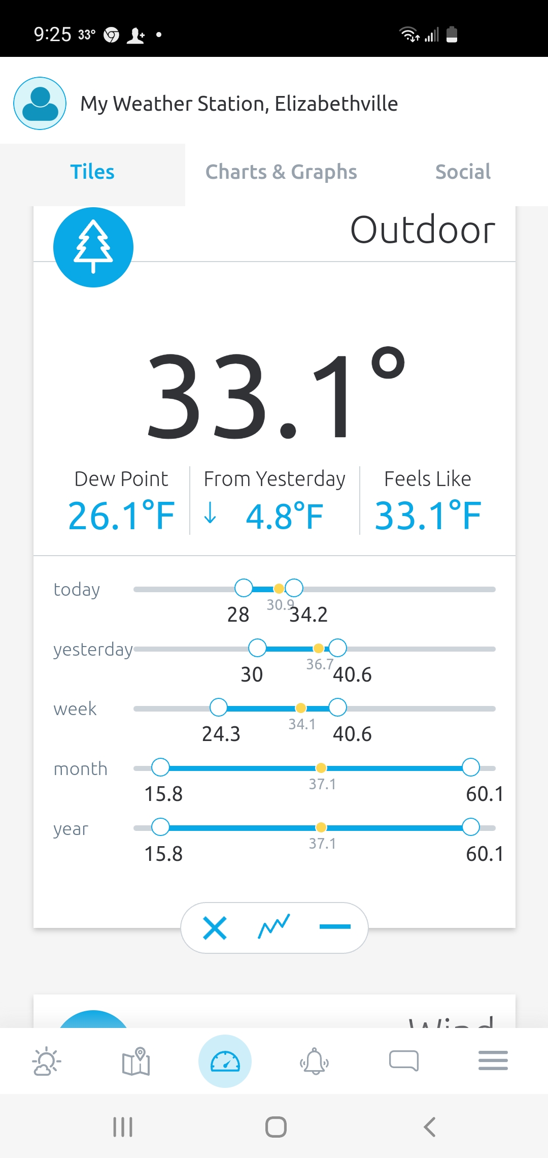
My average for January was 37.1 -
Central PA Winter 2022/2023
mahantango#1 replied to Blizzard of 93's topic in Upstate New York/Pennsylvania
Gone the next run...replaced by 60 degree warmth. -
Central PA Winter 2022/2023
mahantango#1 replied to Blizzard of 93's topic in Upstate New York/Pennsylvania
Cause no one wants to steal your optimsim. -
Central PA Winter 2022/2023
mahantango#1 replied to Blizzard of 93's topic in Upstate New York/Pennsylvania
I can't believe we ended up with 2 sunny days in a row...much deserved! -
Central PA Winter 2022/2023
mahantango#1 replied to Blizzard of 93's topic in Upstate New York/Pennsylvania
My avg. So far: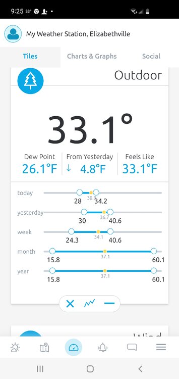
-
Central PA Winter 2022/2023
mahantango#1 replied to Blizzard of 93's topic in Upstate New York/Pennsylvania
Nothing like surprise snow